
Wayne County, Utah facts for kids
Quick facts for kids
Wayne County
|
|
|---|---|

|
|

Location within the U.S. state of Utah
|
|
 Utah's location within the U.S. |
|
| Country | |
| State | |
| Founded | March 10, 1892 |
| Named for | Wayne County, Tennessee |
| Seat | Loa |
| Largest town | Loa |
| Area | |
| • Total | 2,466 sq mi (6,390 km2) |
| • Land | 2,461 sq mi (6,370 km2) |
| • Water | 5.8 sq mi (15 km2) 0.2% |
| Population
(2020)
|
|
| • Total | 2,486 |
| • Density | 1.0081/sq mi (0.38923/km2) |
| Time zone | UTC−7 (Mountain) |
| • Summer (DST) | UTC−6 (MDT) |
| Congressional district | 2nd |
Wayne County is a county in the U.S. state of Utah. In 2020, about 2,486 people lived there. This makes it the fourth smallest county in Utah by population. The main town and county seat is Loa.
Contents
History of Wayne County
Wayne County was a very remote place. It had tough land, so people did not start living there until the 1880s. By 1892, more people had moved in. They wanted their own county because it was hard to get to the main town of Piute County.
So, the Utah Territory decided to create a new county. This happened on March 10, 1892. The new county was named after Wayne County, Tennessee. That county was named after a person called Anthony Wayne. The borders of Wayne County have stayed the same since it was created.
Geography and Nature
Wayne County has many different types of land. Its eastern border follows the Green River. This river flows south to join the Colorado River. After they meet, the combined rivers form more of the county's eastern border.
The middle of the county has the Fremont River and Muddy Creek. The Fremont River starts at Fish Lake in Sevier County. It flows into Wayne County near the northwest corner. It then joins Muddy Creek near Hanksville. Together, they form the Dirty Devil River. This river flows southeast out of the county and into the Colorado River.
The land in Wayne County changes a lot. In the west, you find rough forests. In the east, the land is dry and rocky. The highest point is in the northwest, about 9,888 feet (3,014 meters) high. The county covers about 2,466 square miles (6,387 square kilometers). Most of this is land, with a small amount of water.
The Green River flows through deep canyons in Canyonlands National Park. This park forms the eastern edge of the county. The San Rafael Desert is in the center of the county. On the western side, you can see Thousand Lake Mountain and Boulder Mountain. These mountains have forests, which are very different from the deserts to the east.
Most of the people in Wayne County live in Rabbit Valley. There is also a small town called Hanksville. It has about 200 people and is located north of the Henry Mountains. Wayne County is also home to Capitol Reef National Park.
Main Roads
 SR-12
SR-12 SR-24
SR-24 SR-72
SR-72- SR-95
Neighboring Counties
- Emery County - north
- Grand County - northeast
- San Juan County - east
- Garfield County - south
- Piute County - west
- Sevier County - northwest
National Parks and Forests
- Canyonlands National Park
- Capitol Reef National Park
- Dixie National Forest
- Fishlake National Forest
- Glen Canyon National Recreation Area

People and Population
| Historical population | |||
|---|---|---|---|
| Census | Pop. | %± | |
| 1900 | 1,907 | — | |
| 1910 | 1,749 | −8.3% | |
| 1920 | 2,097 | 19.9% | |
| 1930 | 2,067 | −1.4% | |
| 1940 | 2,394 | 15.8% | |
| 1950 | 2,205 | −7.9% | |
| 1960 | 1,728 | −21.6% | |
| 1970 | 1,483 | −14.2% | |
| 1980 | 1,911 | 28.9% | |
| 1990 | 2,177 | 13.9% | |
| 2000 | 2,509 | 15.3% | |
| 2010 | 2,778 | 10.7% | |
| 2020 | 2,486 | −10.5% | |
| US Decennial Census 1790–1960 1900–1990 1990–2000 2010 2020 |
|||
In 2020, there were 2,486 people living in Wayne County. This means there was about 1 person per square mile. Most people (91.2%) were White. About 3.9% of the people were of Hispanic or Latino background.
The population was almost evenly split between males and females. About 21.6% of the people were under 18 years old. About 24.8% were 65 years or older. The average age was 47.3 years.
There were 1,064 homes in Wayne County. Most of these (66.8%) were families. About 76.5% of homes were owned by the people living in them. The average income for a family was about $62,069 per year. About 10.1% of the people lived below the poverty line.
Most adults in Wayne County have at least a high school diploma. Many have also attended some college or earned a college degree.
Ancestry and Background
In 2017, the largest groups of people by their family background in Wayne County were:
| Largest ancestries (2017) | Percent |
|---|---|
| English | 45.5% |
| German | 16.3% |
| Dutch | 8.4% |
| Danish | 7.6% |
| Irish | 5.8% |
| Scottish | 5.4% |
| Swedish | 3.9% |
| American | 2.3% |
| Welsh | 1.7% |
| Polish | 1.2% |
Towns and Communities
Towns
- Bicknell
- Hanksville
- Loa (This is the county seat, where the county government is located)
- Lyman
- Torrey
Other Communities
- Fremont
- Teasdale
- Caineville
- Fruita
- Grover
- Notom
Education
Wayne County has one school district. It is called the Wayne School District.
Images for kids
-
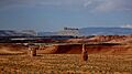
View north of Hanksville from Route 24. Factory Butte in background.

See also
 In Spanish: Condado de Wayne (Utah) para niños
