Caineville, Utah facts for kids
Quick facts for kids
Caineville, Utah
|
|
|---|---|

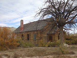
Abandoned former church/schoolhouse
|
|
| Country | United States |
| State | Utah |
| County | Wayne |
| Settled | 1882 |
| Founded by | Elijah Cutler Behunin |
| Named for | John T. Caine |
| Elevation | 4,600 ft (1,400 m) |
| Time zone | UTC-7 (Mountain (MST)) |
| • Summer (DST) | UTC-6 (MDT) |
| ZIP code |
84775
|
| Area code(s) | 435 |
| GNIS feature ID | 1426269 |
Caineville is a small, unincorporated community in the middle of Wayne County, Utah. An "unincorporated community" means it's a group of homes and buildings that doesn't have its own local government like a city or town.
You can find Caineville in Utah, between Capitol Reef National Park and Hanksville. It sits right next to the Fremont River and Utah State Route 24, a main road.
Contents
Exploring Caineville's History
Caineville was settled in 1882. It was named after a person called John T. Caine. The first person to settle here was Elijah Cutler Behunin. He was sent by the LDS Church to help open up this area for more people to live in.
What is an Unincorporated Community?
An unincorporated community like Caineville is a place where people live close together, but it's not officially a city or town. This means it doesn't have its own mayor or city council. Instead, it's usually governed by the county it's in. For Caineville, that's Wayne County.
Fun Things to Do Near Caineville
One exciting place near Caineville is called Swing Arm City. This area is huge, covering about 2,600 acres. It's a special place where people can ride off-highway vehicles (OHVs). These are vehicles like dirt bikes and ATVs that are made for riding on unpaved roads and trails. It's a popular spot for adventure seekers!
How Has Caineville's Population Changed?
Over the years, the number of people living in Caineville has changed quite a bit. For example, in 1900, there were 131 people living there. By 1950, the population had become much smaller, with only 20 residents. This shows how communities can grow and shrink over time.
 | Roy Wilkins |
 | John Lewis |
 | Linda Carol Brown |


