
Hanksville, Utah facts for kids
Quick facts for kids
Hanksville, Utah
|
|
|---|---|
|
Town
|
|

Hollow Mountain Store
|
|

Location in Wayne County and the state of Utah.
|
|
| Country | United States |
| State | Utah |
| County | Wayne |
| Settled | 1882 |
| Incorporated | January 6, 1999 |
| Named for | Ebenezer Hanks |
| Area | |
| • Total | 1.72 sq mi (4.45 km2) |
| • Land | 1.69 sq mi (4.36 km2) |
| • Water | 0.03 sq mi (0.09 km2) |
| Elevation | 4,295 ft (1,309 m) |
| Population
(2010)
|
|
| • Total | 219 |
| • Estimate
(2019)
|
220 |
| • Density | 130.56/sq mi (50.42/km2) |
| Time zone | UTC-7 (Mountain (MST)) |
| • Summer (DST) | UTC-6 (MDT) |
| ZIP codes |
84734
|
| Area code(s) | 435 |
| FIPS code | 49-33100 |
| GNIS feature ID | 2412723 |
Hanksville is a small town in Wayne County, Utah, United States. It is located where two main roads, State Routes 24 and 95, meet. In 2010, about 219 people lived there.
The town is in a cold desert area called the Colorado Plateau. It sits just south of where the Fremont River and Muddy Creek join together. These two rivers form the Dirty Devil River, which then flows southeast to the Colorado River.
Close to Hanksville, you can find the Hanksville-Burpee Quarry. Also, the Mars Desert Research Station is about 7 miles (11 km) northwest of town. This station is a place where scientists study what it might be like to live on Mars. The Bureau of Land Management has a field station in Hanksville for the Henry Mountains area.
Contents
Hanksville's Past: A Look at History
Hanksville was first settled in 1882. For a while, the area around it was known as Graves Valley. In 1885, the town was named Hanksville after Ebenezer Hanks, who was an early settler. The town officially became an "incorporated" town in 1999. This means it became an official city with its own local government.
Bringing Electricity to Hanksville
In 1960, the Rural Electrification Administration brought electricity to Hanksville. This was a big change for the community, making life easier for everyone.
What Drives Hanksville's Economy?
Today, the main ways people make a living in Hanksville are through farming (agriculture), digging for valuable materials (mining), and welcoming visitors (tourism). Tourism is very important because many people come to enjoy the outdoors.
Exploring the Area Around Hanksville
People visit Hanksville for fun activities at places like Lake Powell, Capitol Reef National Park, the Henry Mountains, the San Rafael Swell, Goblin Valley State Park, and Factory Butte. They also come to enjoy the quietness of the surrounding deserts and narrow canyons.
Hanksville and the Wild West
Long ago, Hanksville was a place where famous outlaws like Butch Cassidy and his gang, the Wild Bunch, would get supplies. They used to hide out at a place called Robbers Roost, which is in the desert southeast of town.
The Uranium Rush in Hanksville
After World War II, there was a big rush to find uranium. Hanksville became a key place for people looking for and digging up uranium in the deserts of the Colorado Plateau. You can still find many old, abandoned mines in the deserts around the town today.
Who Lives in Hanksville: Demographics
| Historical population | |||
|---|---|---|---|
| Census | Pop. | %± | |
| 1890 | 81 | — | |
| 1900 | 46 | −43.2% | |
| 1910 | 77 | 67.4% | |
| 1920 | 141 | 83.1% | |
| 1930 | 81 | −42.6% | |
| 1940 | 129 | 59.3% | |
| 1950 | 129 | 0.0% | |
| 1960 | 169 | 31.0% | |
| 1970 | 181 | 7.1% | |
| 1980 | 351 | 93.9% | |
| 1990 | 324 | −7.7% | |
| 2000 | 362 | 11.7% | |
| 2010 | 219 | −39.5% | |
| 2019 (est.) | 220 | 0.5% | |
| U.S. Decennial Census | |||
According to the 2010 census, 219 people lived in Hanksville. There were 94 homes or housing units. Most of the people living there, about 98.2%, were White. A small number were Asian (0.5%), and 1.4% were from two or more racial backgrounds. About 0.9% of the population was Hispanic or Latino.
Hanksville's Weather: Climate Information
Hanksville has an arid climate, which means it's a very dry, cold desert. This type of climate is called "BWk" on climate maps. The average yearly temperature is about 53.9°F (12.2°C). The town gets about 6.16 inches (156.5 mm) of rain each year.
| Climate data for Hanksville, Utah, 1991–2020 normals, extremes 1910–2022 | |||||||||||||
|---|---|---|---|---|---|---|---|---|---|---|---|---|---|
| Month | Jan | Feb | Mar | Apr | May | Jun | Jul | Aug | Sep | Oct | Nov | Dec | Year |
| Record high °F (°C) | 69 (21) |
75 (24) |
88 (31) |
98 (37) |
107 (42) |
110 (43) |
114 (46) |
110 (43) |
105 (41) |
97 (36) |
82 (28) |
70 (21) |
114 (46) |
| Mean maximum °F (°C) | 57.4 (14.1) |
65.3 (18.5) |
78.8 (26.0) |
87.5 (30.8) |
96.9 (36.1) |
104.4 (40.2) |
108.0 (42.2) |
104.3 (40.2) |
98.5 (36.9) |
88.2 (31.2) |
70.4 (21.3) |
57.4 (14.1) |
108.4 (42.4) |
| Mean daily maximum °F (°C) | 43.1 (6.2) |
51.2 (10.7) |
63.8 (17.7) |
70.8 (21.6) |
81.1 (27.3) |
93.4 (34.1) |
98.7 (37.1) |
95.2 (35.1) |
86.3 (30.2) |
71.5 (21.9) |
55.7 (13.2) |
42.9 (6.1) |
71.1 (21.8) |
| Daily mean °F (°C) | 29.1 (−1.6) |
36.2 (2.3) |
46.4 (8.0) |
53.1 (11.7) |
62.8 (17.1) |
73.1 (22.8) |
79.8 (26.6) |
76.8 (24.9) |
67.1 (19.5) |
53.3 (11.8) |
39.7 (4.3) |
29.0 (−1.7) |
53.9 (12.1) |
| Mean daily minimum °F (°C) | 15.2 (−9.3) |
21.1 (−6.1) |
28.9 (−1.7) |
35.3 (1.8) |
44.4 (6.9) |
52.7 (11.5) |
60.9 (16.1) |
58.3 (14.6) |
47.9 (8.8) |
35.1 (1.7) |
23.6 (−4.7) |
15.0 (−9.4) |
36.5 (2.5) |
| Mean minimum °F (°C) | 1.2 (−17.1) |
6.8 (−14.0) |
16.4 (−8.7) |
23.6 (−4.7) |
33.1 (0.6) |
42.1 (5.6) |
51.1 (10.6) |
48.8 (9.3) |
35.7 (2.1) |
22.0 (−5.6) |
10.7 (−11.8) |
2.6 (−16.3) |
−2.3 (−19.1) |
| Record low °F (°C) | −35 (−37) |
−33 (−36) |
4 (−16) |
10 (−12) |
23 (−5) |
31 (−1) |
38 (3) |
35 (2) |
24 (−4) |
−6 (−21) |
−8 (−22) |
−24 (−31) |
−35 (−37) |
| Average precipitation inches (mm) | 0.40 (10) |
0.39 (9.9) |
0.47 (12) |
0.45 (11) |
0.43 (11) |
0.23 (5.8) |
0.71 (18) |
0.57 (14) |
0.83 (21) |
0.87 (22) |
0.47 (12) |
0.34 (8.6) |
6.16 (155.3) |
| Average snowfall inches (cm) | 2.5 (6.4) |
1.1 (2.8) |
0.5 (1.3) |
0.0 (0.0) |
0.0 (0.0) |
0.0 (0.0) |
0.0 (0.0) |
0.0 (0.0) |
0.0 (0.0) |
0.1 (0.25) |
0.6 (1.5) |
2.5 (6.4) |
7.3 (18.65) |
| Average precipitation days (≥ 0.01 in) | 4.2 | 4.4 | 4.0 | 3.7 | 3.7 | 2.3 | 4.5 | 5.3 | 4.7 | 4.1 | 2.8 | 3.6 | 47.3 |
| Average snowy days (≥ 0.1 in) | 1.4 | 0.6 | 0.3 | 0.0 | 0.0 | 0.0 | 0.0 | 0.0 | 0.0 | 0.1 | 0.5 | 1.6 | 4.5 |
| Source 1: NOAA | |||||||||||||
| Source 2: National Weather Service | |||||||||||||
Images for kids
-
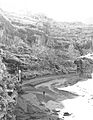
The Dirty Devil River in 1954, near Hanksville.

See also
 In Spanish: Hanksville (Utah) para niños
