
Muddy Creek (central Utah) facts for kids

Muddy Creek is a cool stream in central Utah, United States. It flows through parts of Emery, Sanpete, Sevier, and Wayne counties. Imagine a long, winding water path cutting through the land!
Contents
The Journey of Muddy Creek
Where Muddy Creek Starts
Muddy Creek begins high up in the mountains. It starts on the eastern side of the Wasatch Plateau. Here, the land is over 10,500 feet (3,200 m) (about 3,200 meters) above sea level.
Flowing Through Utah
The creek first flows south near the town of Emery. Then, it turns southeast and goes under Interstate 70. After that, it enters the western part of the San Rafael Swell. This is a huge, uplifted area of rock.
Amazing Rock Formations
As Muddy Creek continues southeast, it passes cool spots like Hondu Arch. It also goes by the Tomsich Butte mining area. Then, the creek starts its amazing journey through a narrow slot canyon. This canyon is made of Coconino Sandstone. People call this special part "the Chute."
Reaching the Rivers
After "the Chute," Muddy Creek joins with Chimney Canyon. It also flows past the Hidden Splendor Mine area. Finally, it leaves the San Rafael Reef at the end of Muddy Creek Gorge. Further down, it travels through the Blue Hills badlands near Caineville. It even cuts through rock from the Jurassic period, called the Morrison Formation. Dinosaur fossils have been found here!
Muddy Creek is about 100 miles (160 km) (160 kilometers) long. It drops about 6,000 feet (1,800 m) (1,800 meters) in height from start to finish. It eventually meets the Fremont River. This meeting happens north of Hanksville. When they join, they form the Dirty Devil River. The Dirty Devil River then flows south to meet the mighty Colorado River.
An Ancient River
Muddy Creek is a very old river. It existed even before the San Rafael Swell uplifted. The Swell rose about 60 to 40 million years ago. But Muddy Creek kept flowing, cutting its way through the rising land. This is why it's called "superimposed" on the Swell. It means the river's path was set before the land changed.
Muddy Creek Wilderness
Protecting Nature
In 2019, the U.S. Congress officially named the Muddy Creek Wilderness. This special area protects the wild part of the creek that flows into the San Rafael Swell.
A Vast Protected Area
The Muddy Creek Wilderness covers a huge area. It is about 98,023 acres (almost 40,000 hectares) big! The U.S. Bureau of Land Management takes care of this wilderness. They make sure it stays wild and beautiful for everyone.
Images for kids
-
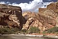
Muddy Creek Gorge, looking northwest toward its mouth at the southeastern edge of the Swell
-
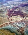
Aerial view of Muddy Creek cutting through the San Rafael Reef and Swell
-
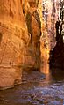
The Chute of Muddy Creek


