Emery, Utah facts for kids
Quick facts for kids
Emery, Utah
|
|
|---|---|
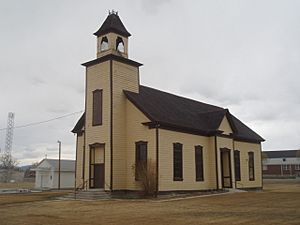
Emery LDS Church, built 1898−1900, is the oldest surviving religious building in town.
|
|
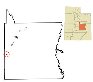
Location in Emery County and the state of Utah
|
|
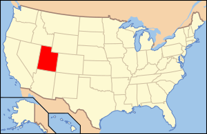
Location of Utah in the United States
|
|
| Country | United States |
| State | |
| County | Emery |
| Named for | George W. Emery |
| Area | |
| • Total | 1.23 sq mi (3.18 km2) |
| • Land | 1.23 sq mi (3.18 km2) |
| • Water | 0.00 sq mi (0.00 km2) |
| Elevation | 6,253 ft (1,906 m) |
| Population
(2010)
|
|
| • Total | 288 |
| • Estimate
(2019)
|
268 |
| • Density | 218.24/sq mi (84.24/km2) |
| Time zone | UTC-7 (Mountain (MST)) |
| • Summer (DST) | UTC-6 (MDT) |
| ZIP code |
84522
|
| Area code(s) | 435 |
| FIPS code | 49-22870 |
| GNIS feature ID | 1440926 |
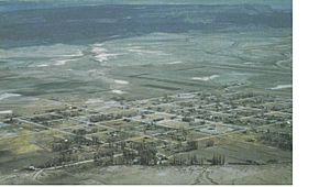
Emery is a small town located in Emery County, Utah, United States. In 2010, the town had a population of 288 people.
Contents
The Story of Emery
Ancient Times: Dinosaurs and Early People
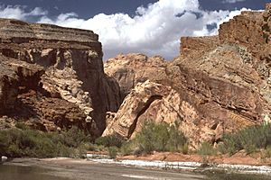
Emery is found at the base of mountains that hold the North Horn Formation. This area has many fossils from the Cretaceous and Tertiary periods. These fossils include tiny organisms and plant spores. Near Emery, Flagstaff Peak has lots of dinosaur bones, ancient mammal remains, and even petrified dinosaur footprints. The elevation here is about 7,000 feet (2,134 meters).
Fremont People and Early Explorers
The Fremont culture was a group of people who lived in this area from about AD 700 to 1300. They were a different group from the Ancestral Pueblo peoples but lived around the same time. The culture is named after the Fremont River, where their first sites were found. This river flows near Emery.
Two important Fremont culture sites are located north and south of Emery. People have found old items like pottery, grinding stones (called manos and metates), and weapons along Muddy and Ivie creeks. Fremont pottery is special because of the materials used to make it. The temper (sand or rock added to clay) helps identify different types of Fremont pottery.
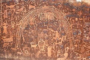
A unique type of painted bowl, called Ivie Creek black-on-white, is found near the southern Wasatch Plateau. The Rochester Rock Art Panel, about 3 miles (5 km) west of Emery, has important rock art made by the Fremont people. Sadly, this site has been damaged by vandals and thieves.
The first Europeans to enter this region, known as Castle Valley, were Spanish explorers. The oldest names in Emery County, like San Rafael and Sinbad, are Spanish. These names come from the time when Spanish priests, explorers, fur traders, and frontiersmen used the Old Spanish Trail.
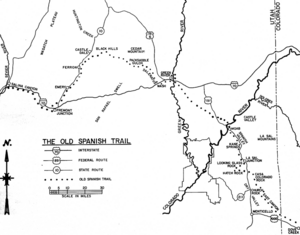
From about 1776 to the mid-1850s, the Old Spanish Trail passed through Emery. It came from Santa Fe, New Mexico, crossed the Colorado River at Moab, and the Green River where the city of Green River is now. Then it went across the San Rafael desert into Castle Valley, passing along the eastern part of Emery. This trail was used by Spanish traders who captured and sold Native Americans as slaves.
East of Emery, a large group of wild horses lives. These wild horses and burros have been in the San Rafael Swell area since the Old Spanish Trail began in the early 1800s. Early travelers sometimes lost their animals, or they were taken by Native Americans or rustlers. Many of these animals were strong and healthy, meant for trading in California. Local ranches also released their domestic horses, adding to the wild herds.
By the early 1900s, there were many wild horses and burros. People called mustangers would capture and sell them. This continued until the Wild and Free-Roaming Horses and Burros Act of 1971 was passed. Now, the Bureau of Land Management (BLM) takes care of these wild animals under federal law.
In the summer of 1853, Captain John W. Gunnison was sent by the United States War Department. His job was to find a railroad route to the Pacific coast. He and Lt. E. G. Beckwith explored Castle Valley and passed near Emery in October 1853. Gunnison described the area as very dry and rocky, with lots of alkali (a type of salt) that looked like snow. He thought the land wouldn't be useful unless valuable minerals were found.
Settling Emery: A New Beginning
One local story says that the first settlers stopped in the area because of a strong wind storm. They decided to wait for it to pass, but the wind never stopped. So, they decided to settle there. This story is probably a joke about how windy it can be in Emery.
The first settlers in Emery came from Sanpete County, Utah. This was unusual because most settlers at the time moved west, but these families moved east, even crossing a mountain range. Their first attempt to settle was at Muddy Creek. This stream flowed down a wide canyon and into the Dirty Devil River. The area around Muddy Creek had tall grass, sagebrush, and cottonwood trees. It also had thorny bushes with sharp spines called bull berry bushes. The berries could be dried or made into jams.
Among these early settlers were the Charles Johnson, Marenus, and Joseph Lund families. Casper Christensen and Fred Acord also brought their families. They started building cabins and planting crops. Joseph Lund built a small one-room log cabin, but he got discouraged and left it for Casper Christensen. This cabin still exists and has been moved to This Is the Place Heritage Park in Salt Lake City.
Most travelers came through Salina Canyon and Spring Canyon. These were barely more than deer trails. The roads were very bad and often hard to pass. People traveled by horseback, wagon, or on snowshoes in winter.
Another group of families settled farther up the canyon around the same time. They came from Beaver, Mayfield, and Sterling. They called themselves "The Beaver Brothers." This group included Dan, Miles, and Samuel Miller, George Collier, and Samuel Babbett. Some of them also got discouraged and left in the first year. The Millers moved to the lower part of Muddy Creek canyon, which has been called Miller's Canyon ever since.
Several miles south, on Quitchupah Creek, other families tried to homestead. This land was even drier than Muddy Creek. In the 1870s, Brigham Young asked several families from Sanpete County to settle on Muddy Creek.
Most of the first homes on Muddy Creek were dugouts. A dugout was a room dug into the side of a hill or a riverbank. The front was very simple, sometimes just a blanket covering the opening. Windows were small holes covered with heavy greased paper or white canvas. Each dugout had a fireplace for heat, cooking, and light. In summer, it got too hot inside, so cooking was done outdoors. The roof was made of poles covered with willows and dirt. These roofs were good in dry weather but leaked a lot when it rained. They also attracted snakes, rats, mice, and spiders. The floors were usually dirt or sometimes rock.
From 1882 to 1885, many families moved to the Muddy Creek area. Many of them were Danish immigrants. By 1885, people realized the canyon wasn't wide enough for many farms. More fertile land was found south of the Muddy.
To settle this new land, settlers needed to bring water from Muddy Creek through a tunnel. It took almost three years to dig this tunnel. The settlers had no trained engineers. They made their own calculations, started digging from opposite sides of the hill, and dealt with many cave-ins. They kept the tunnel at the correct level and connected both sides almost perfectly.
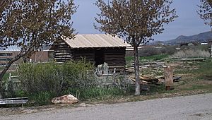
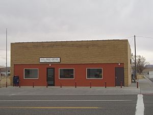
The year 1883 was very important for Casper Christensen. On April 15, he became the leader of the Muddy Creek Branch of the Church of Jesus Christ of Latter-day Saints. On August 26, his daughter, Bellette, was born. She was the first baby girl born on Muddy Creek. On September 2, the Emery Ward was formed, with Casper Christensen as its bishop. Then, on November 19, he became the official postmaster at Muddy, in Emery County, Utah Territory. His daughter, Hannah, helped him.
Once, a postal inspector found Casper Christensen working in a field. The inspector tried to explain that he needed to check the postal records. Finally, the inspector said, "You don't seem to know who I am. I am a postal inspector." Casper Christensen proudly replied, "And YOU don't know who I am. I'm the Bishop on the Creek!" Town residents still use this phrase when someone acts too important.
Residents from Muddy Creek and Quitchupah moved together to this new townsite. They built log cabins using logs from nearby mountains. The logs were smoothed on one side and fit together. The gaps between the logs were filled with mud or clay. Willows were used as lath, nailed to the logs, and then plastered with mud. This mud was smoothed and painted with a whitewash made of lime. The roofs were made of rough wood, covered with straw or brush, and then a layer of dirt. Later, roofs improved when cedar shingles became available.
The town of Muddy later changed its name to "Emery," named after Governor George W. Emery. However, both names were used for a while. Emery has always been a farming community. Ranching and farming are the main ways people make a living. The town grew and had its own school. But after World War II, the population dropped because there were fewer jobs. It stayed around 300 residents.
Later, coal was found south of the town, and several mines opened. People hoped this would bring more residents. However, with lower coal prices, new mining operations haven't been needed.
On November 2, 1967, a powerful F2 tornado destroyed the Last Chance Motel. Furniture and bedding were thrown hundreds of yards. The tornado happened at an unusual time, 5:30 AM, but luckily, no one was hurt.
Geography and Weather
Emery is located in the western part of Emery County. It is along Utah State Route 10. This road goes northeast about 25 miles (40 km) to Castle Dale, which is the county seat. It goes southwest about 12 miles (19 km) to Interstate 70.
According to the United States Census Bureau, the town covers a total area of about 1.23 square miles (3.18 square kilometers). All of this area is land.
Climate in Emery
The weather in Emery can vary a lot. Here's a look at the average temperatures and precipitation:
| Climate data for Salina 24 E, Utah, 1991–2020 normals, 1986-2020 extremes: 7560ft (2304m) | |||||||||||||
|---|---|---|---|---|---|---|---|---|---|---|---|---|---|
| Month | Jan | Feb | Mar | Apr | May | Jun | Jul | Aug | Sep | Oct | Nov | Dec | Year |
| Record high °F (°C) | 58 (14) |
57 (14) |
69 (21) |
74 (23) |
87 (31) |
90 (32) |
93 (34) |
92 (33) |
90 (32) |
78 (26) |
64 (18) |
57 (14) |
93 (34) |
| Mean maximum °F (°C) | 46.0 (7.8) |
48.6 (9.2) |
58.8 (14.9) |
67.7 (19.8) |
75.6 (24.2) |
84.5 (29.2) |
87.1 (30.6) |
84.7 (29.3) |
79.9 (26.6) |
69.9 (21.1) |
56.0 (13.3) |
46.9 (8.3) |
88.0 (31.1) |
| Mean daily maximum °F (°C) | 32.6 (0.3) |
34.7 (1.5) |
43.5 (6.4) |
50.2 (10.1) |
61.1 (16.2) |
73.3 (22.9) |
79.6 (26.4) |
77.0 (25.0) |
68.7 (20.4) |
55.4 (13.0) |
41.1 (5.1) |
31.6 (−0.2) |
54.1 (12.3) |
| Daily mean °F (°C) | 24.2 (−4.3) |
26.2 (−3.2) |
33.7 (0.9) |
39.4 (4.1) |
48.8 (9.3) |
59.3 (15.2) |
66.3 (19.1) |
64.1 (17.8) |
55.7 (13.2) |
44.0 (6.7) |
31.7 (−0.2) |
23.3 (−4.8) |
43.1 (6.2) |
| Mean daily minimum °F (°C) | 15.8 (−9.0) |
17.7 (−7.9) |
23.9 (−4.5) |
28.7 (−1.8) |
36.6 (2.6) |
45.3 (7.4) |
53.1 (11.7) |
51.1 (10.6) |
42.7 (5.9) |
32.6 (0.3) |
22.3 (−5.4) |
15.1 (−9.4) |
32.1 (0.0) |
| Mean minimum °F (°C) | −0.9 (−18.3) |
2.0 (−16.7) |
9.2 (−12.7) |
16.3 (−8.7) |
23.6 (−4.7) |
32.8 (0.4) |
44.6 (7.0) |
42.4 (5.8) |
30.6 (−0.8) |
19.4 (−7.0) |
7.1 (−13.8) |
−1.8 (−18.8) |
−5.2 (−20.7) |
| Record low °F (°C) | −14 (−26) |
−19 (−28) |
−5 (−21) |
4 (−16) |
10 (−12) |
19 (−7) |
27 (−3) |
33 (1) |
20 (−7) |
2 (−17) |
−2 (−19) |
−15 (−26) |
−19 (−28) |
| Average precipitation inches (mm) | 0.93 (24) |
1.03 (26) |
1.07 (27) |
0.99 (25) |
1.22 (31) |
0.73 (19) |
1.15 (29) |
1.49 (38) |
1.40 (36) |
1.32 (34) |
0.97 (25) |
1.02 (26) |
13.32 (340) |
| Average snowfall inches (cm) | 11.80 (30.0) |
15.50 (39.4) |
8.80 (22.4) |
4.40 (11.2) |
1.70 (4.3) |
0.30 (0.76) |
0.00 (0.00) |
0.00 (0.00) |
0.00 (0.00) |
2.80 (7.1) |
7.80 (19.8) |
16.20 (41.1) |
69.3 (176.06) |
| Source 1: NOAA | |||||||||||||
| Source 2: XMACIS2 (records & monthly max/mins) | |||||||||||||
| Climate data for Emery, Utah | |||||||||||||
|---|---|---|---|---|---|---|---|---|---|---|---|---|---|
| Month | Jan | Feb | Mar | Apr | May | Jun | Jul | Aug | Sep | Oct | Nov | Dec | Year |
| Record high °F (°C) | 63 (17) |
68 (20) |
81 (27) |
85 (29) |
95 (35) |
100 (38) |
100 (38) |
102 (39) |
99 (37) |
88 (31) |
71 (22) |
64 (18) |
102 (39) |
| Mean daily maximum °F (°C) | 37 (3) |
43 (6) |
53 (12) |
61 (16) |
71 (22) |
82 (28) |
88 (31) |
86 (30) |
77 (25) |
65 (18) |
49 (9) |
39 (4) |
63 (17) |
| Mean daily minimum °F (°C) | 12 (−11) |
18 (−8) |
27 (−3) |
34 (1) |
43 (6) |
52 (11) |
58 (14) |
56 (13) |
47 (8) |
36 (2) |
23 (−5) |
14 (−10) |
35 (2) |
| Record low °F (°C) | −17 (−27) |
−15 (−26) |
1 (−17) |
13 (−11) |
22 (−6) |
28 (−2) |
39 (4) |
33 (1) |
22 (−6) |
8 (−13) |
−4 (−20) |
−21 (−29) |
−21 (−29) |
| Average precipitation inches (mm) | 0.66 (17) |
0.64 (16) |
0.74 (19) |
0.51 (13) |
0.74 (19) |
0.41 (10) |
1.04 (26) |
0.97 (25) |
1.02 (26) |
0.98 (25) |
0.57 (14) |
0.39 (9.9) |
8.64 (219) |
People of Emery
| Historical population | |||
|---|---|---|---|
| Census | Pop. | %± | |
| 1890 | 240 | — | |
| 1900 | 572 | 138.3% | |
| 1910 | 525 | −8.2% | |
| 1920 | 650 | 23.8% | |
| 1930 | 657 | 1.1% | |
| 1940 | 618 | −5.9% | |
| 1950 | 488 | −21.0% | |
| 1960 | 326 | −33.2% | |
| 1970 | 216 | −33.7% | |
| 1980 | 372 | 72.2% | |
| 1990 | 300 | −19.4% | |
| 2000 | 308 | 2.7% | |
| 2010 | 288 | −6.5% | |
| 2019 (est.) | 268 | −6.9% | |
| U.S. Decennial Census | |||
In the year 2000, there were 308 people living in Emery. These people lived in 123 households, and 89 of those were families. The town had about 253.7 people per square mile (98.3/km2). There were 140 homes in total.
Most of the people in Emery (97.73%) were White. About 0.97% were Native American, and 1.30% were from two or more races. About 0.97% of the population was Hispanic or Latino.
Out of the 123 households, 29.3% had children under 18 living with them. Most households (61.0%) were married couples living together. About 6.5% had a female head of household with no husband present. And 27.6% were not families.
About 26.8% of all households had only one person living there. About 12.2% had someone living alone who was 65 years old or older. On average, there were 2.50 people in each household and 3.03 people in each family.
The population in Emery was spread out by age. About 28.9% were under 18 years old. About 5.8% were between 18 and 24. About 19.2% were between 25 and 44. About 24.4% were between 45 and 64. And 21.8% were 65 years old or older. The average age in Emery was 43 years. For every 100 females, there were about 98.7 males.
The average income for a household in Emery was $40,469. For families, the average income was $51,875. Men earned about $40,104, while women earned about $31,250. The income per person was $17,195. About 12.1% of families and 13.1% of the total population lived below the poverty line. This included 14.3% of those under 18 and 19.3% of those 65 or older.
Famous People from Emery
- Clay Christiansen, a composer and famous organist for the Mormon Tabernacle Choir.
See also
 In Spanish: Emery (Utah) para niños
 | William L. Dawson |
 | W. E. B. Du Bois |
 | Harry Belafonte |


