
Quitchupah Creek facts for kids

Quitchupah Creek is a stream in central Utah, in the western United States. It flows through parts of Emery and Sevier Counties. The name "Quitchupah" comes from the Ute language and means "animals fare poorly." This creek is special because of the ancient Fremont culture rock art found along its banks.
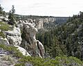
The creek is part of the larger Colorado River Basin. All the water in this area flows into Quitchupah Creek or its smaller branches, like East Spring Canyon and Water Hollow. It also flows through a cool place called Convulsion Canyon.
Contents
Journey of Quitchupah Creek
Quitchupah Creek starts high up in the mountains, about 9,000 feet (2,743 meters) above sea level. After leaving Convulsion Canyon, it goes under Utah State Route 10 near the town of Emery.
Where the Creek Ends Up
The creek then flows southeast and meets Ivie Creek. Ivie Creek eventually joins Muddy Creek. Muddy Creek passes by the Hidden Splendor Mine area and cuts through the San Rafael Reef at a place called Muddy Creek Gorge.
After flowing for about 100 miles (160 km) and dropping 6,000 feet (1,825 meters) in elevation, Quitchupah Creek joins the Fremont River. Together, they form the Dirty Devil River, just north of Hanksville.
History Along the Creek
Many years ago, the Old Spanish Trail crossed Quitchupah Creek. This was an important trade route. Later, in the 1880s, some Mormon settlers tried to build a community along the creek, but they later left the area.
Recently, there was news about a plan to build a road along Quitchupah Creek. This road would connect coal mines in Convulsion Canyon to Utah State Route 10.
Images for kids
-
A view of Quitchupah Canyon

