
San Rafael Reef facts for kids
Quick facts for kids San Rafael Reef |
|
|---|---|

Western San Rafael Reef, Utah, looking south
|
|
| Highest point | |
| Geography | |

San Rafael Reef
Location in Utah
|
|
| Location | Emery County, Utah |

The San Rafael Reef is a huge, cool rock formation in central Utah, in a place called Emery County. It's like a giant, wavy wall of rock that stretches for about 75 miles (120 km). This amazing natural feature is part of the larger Colorado Plateau region.
Contents
What Makes the San Rafael Reef Special?
The San Rafael Reef is the eastern edge of a much bigger area called the San Rafael Swell. Imagine a giant bubble of rock that pushed up from underground. The San Rafael Reef is where the edges of that bubble got pushed up very steeply.
This "reef" is mostly made of two types of sandstone: Navajo Sandstone and Wingate Sandstone. Over millions of years, wind and water have carved these steeply tilted rock layers into incredible shapes. You can see tall fins, rounded domes, sheer cliffs, and deep, winding canyons.
Rivers and Amazing Canyons
Several important waterways cut right through the San Rafael Reef. The San Rafael River, Interstate 70, and Muddy Creek all flow through this rocky barrier.
The area is also famous for its many "slot canyons." These are super narrow canyons that twist and turn through the rock. They can be just a few feet wide but hundreds of feet deep! Some popular ones include Crack Canyon, Chute Canyon, and Straight Wash. Exploring them feels like walking through a secret, natural maze.
Protecting the Reef: A Wilderness Area
A big part of the San Rafael Reef is protected as the San Rafael Reef Wilderness. The U.S. Congress officially made it a wilderness area in 2019. This means it's a special place where nature is kept wild and untouched.
This wilderness area covers a huge 60,442 acres (about 244 square kilometers). It is managed by the U.S. Bureau of Land Management. They work to keep this beautiful and unique landscape safe for everyone to enjoy, now and in the future.
Images for kids
-
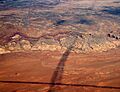
Shadows of contrails over the San Rafael Reef. This shows the San Rafael Swell, the Reef's edge, and the San Rafael Desert.
-
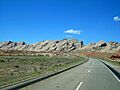
Driving on Interstate 70 towards the eastern end of the San Rafael Reef.
-
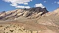
Interstate 70 cuts right through the impressive San Rafael Reef.


