San Rafael River facts for kids
Quick facts for kids San Rafael River |
|
|---|---|

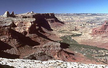
San Rafael River Gorge
|
|

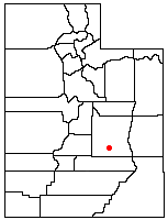
Location of the San Rafael River within Utah
|
|
| Country | United States |
| State | Utah |
| Physical characteristics | |
| River mouth | 38°46′31″N 110°06′17″W / 38.77528°N 110.10472°W |
| Length | 90 miles (140 km) |
The San Rafael River is a river in Utah, United States. It flows for about 90 miles (145 km) through the central part of the state. This river is a branch of the Green River. The Green River eventually joins the Colorado River.
The San Rafael River flows through a dry area called the Colorado Plateau. It is famous for its beautiful, isolated canyons. These canyons are often called the "Little Grand Canyon" because they look similar to the famous Grand Canyon.
Contents
Journey of the San Rafael River
The San Rafael River begins in Emery County. It forms where three smaller streams meet. These streams are Cottonwood Creek, Huntington Creek, and Ferron Creek. They start high up in the Wasatch Plateau mountains.
Flowing Through Canyons
From its start, the river flows mostly to the east. It passes along the north side of the Coal Cliffs. It also flows near a large rock uplift called the San Rafael Swell. This area has amazing rock formations.
The river then goes through two narrow slot canyons. These canyons are carved into Coconino Sandstone. They are known as the Upper and Lower Black Box. This whole area is called the San Rafael Gorge. Many people call it the "Little Grand Canyon" because of its deep, winding paths.
Meeting the Green River
After leaving the San Rafael Gorge, the river flows through the San Rafael Reef. This is a long, rocky ridge. Then, it enters the San Rafael Valley. This valley is about 15 miles (24 km) long.
Finally, the San Rafael River joins the Green River. This meeting point is about 10 miles (16 km) south of the town of Green River. The San Rafael is the last major river that flows into the Green River before the Green River joins the Colorado River in Canyonlands National Park.
Water for Farms
The San Rafael River is also important for farming. Tunnels at the very start of the river, in the Manti-La Sal National Forest, help move water. This water is used for irrigation in Sanpete County. This helps farmers grow crops in the drier western part of the Wasatch Plateau.
 | Janet Taylor Pickett |
 | Synthia Saint James |
 | Howardena Pindell |
 | Faith Ringgold |

