
San Rafael Swell facts for kids
Quick facts for kids San Rafael Swell |
|
|---|---|

The San Rafael Swell from 16,000 feet
|
|
| Highest point | |
| Dimensions | |
| Length | 75 mi (121 km) |
| Width | 40 mi (64 km) |
| Geography | |

San Rafael Swell
Location in Utah
|
|
| Location | Colorado Plateau, Utah, United States |
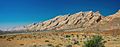
The San Rafael Swell is a huge, dome-shaped area of land in south-central Utah, USA. It's located about 16 miles (26 km) west of Green River. This amazing natural area is about 75 miles (121 km) long and 40 miles (64 km) wide.
The San Rafael Swell was formed when layers of rock were pushed up into a giant dome shape. This happened during a time of major mountain building called the Laramide Orogeny, between 60 and 40 million years ago. Since then, strong but not very common flash floods have carved out the soft rocks. This has created many valleys, canyons, mesas (flat-topped hills), buttes (isolated hills), and badlands (eroded land).
The Swell is part of the Colorado Plateau, a large high-desert area in the western United States.
Template:TOC limit=3
Contents
Exploring the San Rafael Swell's Geography

Interstate 70, a major highway, cuts right through the San Rafael Swell. It divides the area into northern and southern parts. This highway is the only easy way to get into the region by car. The entire Swell is located within Emery County.
The northern part of the Swell is mostly drained by the San Rafael River. The southern part is drained by Muddy Creek. Muddy Creek eventually joins the Fremont River to become the Dirty Devil River. The Dirty Devil River then flows south into the mighty Colorado River. The San Rafael River joins the Green River before it also flows into the Colorado River.
Muddy Creek carves its way through the western edge of the Swell. It then flows through a narrow passage called Muddy Creek Gorge. After that, it crosses the Blue Hills Badlands before meeting the Fremont River.
How the San Rafael Swell Was Formed

The San Rafael Swell was created about 60 million years ago. This happened when very old rocks deep underground moved upwards. This movement caused the layers of rock above them to bend and fold into a giant dome shape. Think of it like pushing a box under a stack of blankets – the blankets will curve over the box.
Over millions of years, water has slowly worn away these rock layers. This erosion has exposed older rocks in the middle of the Swell and younger rocks around its edges. Many of the most impressive landforms you see are made of harder rocks. These include the Jurassic Navajo Sandstone, Jurassic Wingate Sandstone, and Permian Coconino Sandstone.
The eastern edge of the Swell is much steeper than the western side. This steep eastern edge is known as the San Rafael Reef. Both the San Rafael River and Muddy Creek flow from the high Wasatch Plateau and cut straight through this steep Reef. This means these rivers were there before the Swell was pushed up!
Some parts of the Swell look a lot like the planet Mars. Because of this, the Mars Society built the Mars Desert Research Station here. They use it to practice for future missions to Mars.
Unique Plants and Animals of the Swell
The San Rafael Swell is home to many unique plants that grow nowhere else in the world. One example is the endangered San Rafael cactus (Pediocactus despainii). It's important to protect these special plants.
A Look at the San Rafael Swell's History
The San Rafael Swell has a rich history, with signs of ancient Native American cultures. You can find pictographs (paintings on rock) and petroglyphs (carvings on rock) left by groups like the Fremont, Paiute, and Ute. Famous examples include the Millsite Rock Art and the Buckhorn Draw Pictograph Panel.
From around 1776 to the mid-1850s, the Old Spanish Trail, a trade route, passed through or just north of the Swell. In the last 150 years, parts of the Swell have been used for grazing sheep and cattle. People also mined uranium here. Many of the gravel roads inside the Swell were originally built to help with uranium mining.
Even though it's surrounded by towns like Price, Green River, and Hanksville, no one lives permanently in the Swell itself.
Hollywood filmmakers have even used the Swell as a setting for alien planets! It appeared as the planet Vulcan in the 2009 movie Star Trek and as an alien world in Galaxy Quest.
Over the years, there have been ideas to make the San Rafael Swell a National Monument. This would give it special protection. In 2018, a bill was proposed to call it the "Jurassic National Monument."
The San Rafael Recreation Area

The U.S. Bureau of Land Management helps manage the San Rafael Swell. In 2019, a law was signed that protected about 217,000 acres of the area as the San Rafael Swell Recreation Area.
.png)
As part of this law, several wilderness areas were also set aside around the Recreation Area. These are places where nature is protected and human activity is limited. Some of these wilderness areas include:
- Big Wild Horse Mesa
- Cold Wash
- Devil’s Canyon
- Eagle Canyon
- Horse Valley
- Little Ocean Draw
- Little Wild Horse Canyon
- Lower Last Chance
- Mexican Mountain
- Middle Wild Horse Mesa
- Muddy Creek
- Red’s Canyon
- San Rafael Reef
- Sid’s Mountain
Cattle grazing is only allowed in parts of the Swell that are not protected as wilderness. Goblin Valley State Park, known for its unique mushroom-shaped rock formations, is located on the southeastern edge of the San Rafael Swell.
Fun Activities in the San Rafael Swell
The San Rafael Swell is a great place for outdoor adventures! Many people come here for:
- Hiking
- Backpacking
- Horseback riding
- Trail running
- Riding all-terrain vehicles (ATVs)
The steep, narrow slot canyons in the San Rafael Reef are very popular for technical canyoneering. This involves hiking, climbing, and sometimes rappelling through canyons.
The Eastern Reef is also a favorite spot for rock climbers. It has some of the longest climbing routes in Utah and is sometimes called the "Sandstone Alps."
Gallery
-
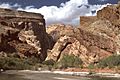
Entrance to the Muddy Creek Gorge
-
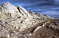
Eastern slope of the San Rafael Reef
-
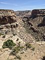
Little Grand Canyon
-
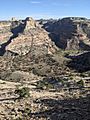
The Wedge Overlook of the Little Grand Canyon


Images for kids
-
San Rafael Swell, looking westward, with US Interstate 70 passing through.
-

East side of the San Rafael Swell
