
Green River (Colorado River tributary) facts for kids
Quick facts for kids Green River |
|
|---|---|

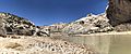
The Green River near Canyonlands National Park
|
|

Green River watershed
|
|
| Other name(s) | Seeds-kee-dee-Agie |
| Country | United States |
| State | Wyoming, Colorado, Utah |
| Cities | Green River, Wyoming, Green River, Utah |
| Physical characteristics | |
| Main source | Wind River Mountains Wyoming 43°09′13″N 109°40′18″W / 43.15361°N 109.67167°W |
| River mouth | Colorado River Canyonlands National Park, San Juan County, Utah 38°11′21″N 109°53′07″W / 38.18917°N 109.88528°W |
| Length | 730 mi (1,170 km) |
| Basin features | |
| Basin size | 48,100 sq mi (125,000 km2) |
| Tributaries | |
The Green River is a very important river in the western United States. It is the main river that flows into the Colorado River. The area of land that drains into the Green River is called its watershed. This area, known as the Green River Basin, covers parts of Wyoming, Utah, and Colorado.
The Green River is about 730 miles (1,170 km) long. It starts in the Wind River Mountains of Wyoming. Most of its journey is through Wyoming and Utah. About 40 miles (64 km) of the river flows through western Colorado. The river travels through the Colorado Plateau and some amazing canyons. When the Green River joins the Colorado River, it is almost as big. It often carries more silt (fine dirt) than the Colorado River. Near Green River, Utah, the river's average flow is 6,121 cubic feet (173.3 m3) per second.
You might wonder why the Green River is called a "tributary" of the Colorado River. This is mostly because of political decisions. Long ago, the river we now call the Colorado River was known as the Grand River before it met the Green River. In 1921, a politician named Edward T. Taylor from Colorado asked the U.S. Congress to change the Grand River's name to the Colorado River. This change happened on July 25, 1921. Some people from Wyoming and Utah, and even the United States Geological Survey, disagreed. They pointed out that the Green River's watershed was larger than the Grand River's. However, the Grand River usually carried more water where the two rivers met.
Contents
Exploring the Green River's Journey


The Green River begins in western Wyoming. It starts in northern Sublette County. This is on the western side of the Continental Divide in the Bridger–Teton National Forest. It flows south through a place called the Upper Green River Valley. Then it turns southwest and meets the Big Sandy River.
Near the town of La Barge, the river flows into Fontenelle Reservoir. This reservoir was created by the Fontenelle Dam. After that, it goes through open, grassy plains. Here, famous old trails like the Oregon Trail, California Trail, and Mormon Trail crossed the river. It continues south past the town of Green River, Wyoming. Then it flows into the Flaming Gorge Reservoir. This reservoir is in southwestern Wyoming and northeastern Utah. Before the reservoir was built, the Blacks Fork river joined the Green River south of Green River town. Now, the mouth of Blacks Fork is under the reservoir's water.
South of the Flaming Gorge Dam, the river flows east. It loops around the eastern tip of the Uinta Mountains. It goes from Utah into northwestern Colorado. It passes through Browns Park. Then it turns west and south into Dinosaur National Monument. Here, it flows through the Canyon of the Lodore. The Yampa River joins it at Steamboat Rock.
The Green River then turns west again. It goes back into Utah along the southern edge of the Uintas. This part is called Whirlpool Canyon. In Utah, it winds southwest across the Yampa Plateau. It also flows through the Uintah and Ouray Indian Reservation and the Ouray National Wildlife Refuge. Two miles south of Ouray, Utah, the Duchesne River joins it. Three miles (5 km) further downstream, the White River adds its waters. Ten miles more downstream, the Willow River joins in.
South of the plateau, Nine Mile Creek flows into the Green River. Then the river enters the Roan Cliffs. It flows south through two long canyons, Desolation and Gray canyons. Together, they are 120 mi (192 km) long. In Gray Canyon, the Price River joins the Green. South of the canyon, it passes the town of Green River, Utah. The San Rafael River joins it in southern Emery County. In eastern Wayne County, the Green River winds through Canyonlands National Park. This is where it finally meets the Colorado River.
The Flaming Gorge Dam in Utah is very important. It provides water for farms and mines. It also creates hydroelectric power (electricity from water). This dam was started in the 1950s and finished in 1963. Building it caused a lot of debate. Many people who wanted to protect nature were against it.
The Green River is a big, deep, and powerful river. In its upper parts, it is 100 to 300 feet (30 to 100 m) wide. In its lower parts, it can be 300 to 1,500 feet (460 m) wide. Its depth ranges from 3 to 50 feet (1 to 15 m). Small boats can travel on most of the river. Larger motorboats can go upstream to Flaming Gorge Dam. Where the Oregon Trail crossed, the river was about 400 - 500 feet (150 m) wide. It was usually about 20 feet (6.1 m) deep there.
A Look Back: History of the Green River


Evidence from archaeologists shows that people lived in the canyons and sheltered areas of the Green River valley a long time ago. The Fremont Culture lived here from the 7th to the 13th century. They were semi-nomadic, meaning they moved around. They lived in simple homes dug into the ground. They are famous for their amazing rock art on canyon walls.
Later, the Shoshone and Ute peoples lived in the river basin. Both were nomadic hunters. The Shoshone lived north of the Uinta Mountains. The Utes lived to the south. Today, the Utes have a reservation in the Uintah Basin. The Shoshone people called the river Seeds-kee-dee-Agie. This means "Prairie Hen River."
In 1776, Spanish explorers named the river the Rio de San Buenaventura. Later, Spanish and Mexican explorers started calling it Rio Verde, which means "Green River" in Spanish. No one knows exactly why or when they started using this name. Some ideas are that the water looked green, or the plants along the banks were green. Another idea is that it was named after a fur trapper.
Early American trappers also explored the river. They learned from Native Americans that the Green River flowed into the Colorado River. In 1869, John Wesley Powell explored and mapped the river. During his trips, he and his team gave many of the canyons and features their current names. For example, he named "Bowknot Bend" because the river made a shape like a bowknot.
From the 1840s to the 1860s, many people traveled west on trails like the Oregon Trail. These trails often had to cross the Green River. The river was too big and deep to walk across. So, people used ferries to cross it. These ferries were very important for travelers.
In 1878, the first permanent town in the valley was founded at Vernal. It was started by Mormons. Most of the land in the river valley today is owned by the U.S. government. For a long time, ranching was the main business. But now, tourism is the biggest industry in the area.
A new nuclear power plant, called the Blue Castle Project, might be built near Green River, Utah. It is planned to start construction in 2023. This plant would use a lot of water from the Green River each year.
Valuable Resources of the Green River Basin


The Green River Basin is rich in natural resources. The La Barge oil field was found here in 1924. Oil and natural gas have been produced from this area for many years.
After World War II, more oil was found at Ashley Field. This led to more oil and natural gas being taken from the region. There is also a very large deposit of oil shale in the Green River formation. Oil shale is a type of rock that contains a substance called kerogen. Kerogen is like "uncooked" oil that nature hasn't fully turned into liquid oil yet.
Experts believe there could be a huge amount of oil (between 500 billion and 1.1 trillion barrels) in this oil shale. However, right now, it is very expensive and difficult to turn this rock into usable oil. The cost of getting oil from oil shale is higher than what the oil could be sold for. Also, getting oil from oil shale can have a big impact on the environment.
The Green River Basin also has the world's largest known deposit of trona ore. Trona is used to make soda ash. Mining trona is a big industry near Green River, Wyoming. It provides jobs for over 2000 people. Making soda ash from trona is cheaper in the U.S. than other methods used around the world. The area has also been mined for uranium.
Images for kids
-
The Green River gets its name from the green tint caused by the sediments in its waters. This is at the mouth of Split Mountain Canyon, Dinosaur National Monument, Utah.

See also
 In Spanish: Río Green (río Colorado) para niños
