Mormon Trail facts for kids
Quick facts for kids Mormon Pioneer National Historic Trail |
|
|---|---|
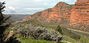
Echo Canyon, Utah on Mormon Trail
|
|
| Location | Illinois, Iowa, Nebraska, Wyoming, Utah, US |
| Nearest city | Nauvoo, Illinois; Salt Lake City, Utah |
| Established | November 10, 1846 |
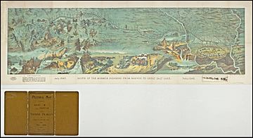
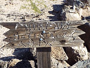
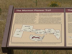
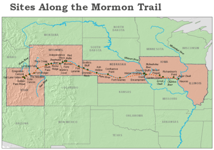
The Mormon Trail is a very long path, about 1,300 miles (2,092 km) from Illinois to Utah. Members of The Church of Jesus Christ of Latter-day Saints traveled this route for about three months. Today, the Mormon Trail is a special part of the United States National Trails System. It is officially called the Mormon Pioneer National Historic Trail.
The Mormon Trail starts in Nauvoo, Illinois. This city was the main home for the Latter Day Saints from 1839 to 1846. The trail ends in Salt Lake City, Utah, which was settled by Brigham Young and his followers starting in 1847. From Council Bluffs, Iowa to Fort Bridger in Wyoming, the trail follows much of the same path as the Oregon Trail and the California Trail. These trails are often called the Emigrant Trail.
The journey for the Mormon pioneers began in 1846. Young and his followers had to leave Nauvoo. They wanted to build a new home for their church in the Great Basin and crossed Iowa. Along the way, some people were asked to create small settlements. They would plant and harvest crops for others who would follow later. During the winter of 1846–47, many travelers stayed in Iowa, nearby states, or in the area that later became Nebraska. The largest group lived in Winter Quarters, Nebraska. In the spring of 1847, Brigham Young led the first group to the Salt Lake Valley. This area was outside the United States at the time and later became Utah.
In the first few years, most travelers were people from Nauvoo who followed Young to Utah. Later, more and more travelers were new church members from the British Isles and Europe.
People used the trail for over 20 years. It was used until the First Transcontinental Railroad was finished in 1869. Among the travelers were the Mormon handcart pioneers from 1856 to 1860. Two of these handcart groups, led by James G. Willie and Edward Martin, faced terrible problems. They started their journey too late and were caught in heavy snowstorms in Wyoming.
Contents
Why They Moved West
Under the leadership of Joseph Smith, Latter Day Saints built several communities across the United States. These were in places like Kirtland, Ohio, Independence, Missouri, and Nauvoo, Illinois. However, the Saints often faced difficulties and had to move often. This was because of disagreements with other settlers. For example, Missouri Governor Lilburn Boggs issued an order that forced all Mormons to leave Missouri. The Latter-day Saints were finally forced to leave Nauvoo in 1846.
After Joseph Smith's death in 1844, the group split into different parts. But most members chose to follow Brigham Young. Under Young's leadership, about 14,000 Mormon citizens from Nauvoo left to find a new home in the West.
The Journey West
After their leader died, Brigham Young believed the Mormons should settle in a place no one else wanted. He felt the remote Great Basin would be a good place for them.
Young studied maps and information about the Great Salt Lake Valley. He talked with mountain men and trappers. He also met Father Pierre-Jean De Smet, a Jesuit missionary who knew the area well. Young then put together a first group, called the vanguard company. Their job was to create a trail to the Rocky Mountains. They would check the trail conditions, find water, and choose a main meeting spot in the Great Basin. They chose a new path north of the Platte and North Platte rivers. This was to avoid problems with other travelers using the Oregon Trail on the river's south side.
In October 1845, a meeting in Quincy demanded that the Latter-day Saints leave Nauvoo by May 1846. Another meeting in Carthage called for a militia to force them out if they didn't leave. To try to meet this deadline and start their journey early, the Latter-day Saints began leaving Nauvoo in February 1846.
1846 Trek Across Iowa
The journey from Nauvoo started on February 4, 1846, led by Brigham Young. Leaving so early meant they faced the harsh winter weather. After crossing the Mississippi River, they traveled across Iowa Territory. They followed old territorial roads and Native American paths.
Young had planned to lead a smaller group of about 300 men to the Great Basin in the summer of 1846. He thought they could cross Iowa and reach the Missouri River in four to six weeks. However, the actual trip across Iowa was much slower. Rain, mud, swollen rivers, and poor planning made it take 16 weeks. This was almost three times longer than expected.
Heavy rains turned the plains of southern Iowa into deep mud. Also, few people had enough supplies for the trip. The bad weather, lack of preparation, and little experience in moving such a large group caused many problems.
The first group reached the Missouri River on June 14. It was clear that the Latter-day Saints could not reach the Great Basin that year. They would have to spend the winter along the Missouri River.
Some of the travelers started a settlement called Kanesville (now Council Bluffs) on the Iowa side of the river. Others moved across the river into what is now Omaha, Nebraska. There, they built a camp called Winter Quarters.
The First Company of 1847
In April 1847, chosen members of the first company gathered. They packed their final supplies. The group was organized into 14 military-style companies. A militia and night guard were also formed. The company had 143 men, including three Black people and eight church leaders. There were also three women and two children. The group had 73 wagons, many animals, and enough supplies for a year. On April 5, the wagon train moved west from Winter Quarters toward the Great Basin.
The journey from Winter Quarters to Fort Laramie took six weeks. The company arrived at the fort on June 1. At Fort Laramie, the first company was joined by members of the Mormon Battalion. These soldiers had been excused due to illness and had spent the winter in Pueblo, Colorado. A group of church members from Mississippi also joined them. At this point, the larger company took the well-known Oregon Trail toward the trading post at Fort Bridger.
Young met mountain man Jim Bridger on June 28. They talked about routes into the Salt Lake Valley. They also discussed if settlements could be built in the mountain valleys of the Great Basin. The company continued through South Pass. They rafted across the Green River and reached Fort Bridger on July 7. Around the same time, 12 more sick members of the Mormon Battalion joined them.
Now facing a tougher journey, Young chose to follow the trail used by the Donner–Reed party the year before. As the first company traveled through the rugged mountains, they split into three parts. Young and others became sick with a "mountain fever" from wood ticks. The small sick group fell behind. A scouting group went ahead to explore the route.
Arrival and New Home
Scouts Erastus Snow and Orson Pratt entered the Salt Lake Valley on July 21. On July 23, Pratt prayed, dedicating the land to God. They started digging irrigation ditches and planted the first fields of potatoes and turnips. On July 24, Young first saw the valley from a "sick" wagon. His friend Wilford Woodruff was driving. Woodruff said Young was happy with the valley's look and declared, "This is the right place, drive on."
In August 1847, Young and some members of the first company returned to Winter Quarters. They needed to organize the groups for the next few years. By December 1847, over 2,000 Mormons had finished the journey to the Salt Lake Valley. This area was then part of Mexican territory.
Farming the wild land was hard at first. Their plows broke when they tried to dig into the dry ground. So, they designed an irrigation system. They flooded the land before plowing, which helped keep the soil moist all year.
Salt Lake City was planned and became the church's main center. Hard work created a thriving community. Fun was also important in their new home. The first public building they built was a theater.
However, it wasn't long before the United States caught up with them. In 1848, after the war with Mexico ended, the land where they settled became part of the United States.
Continuing the Journey
Each year, during the Mormon migration, people were organized into "companies." Each company was named after its leader and divided into smaller groups. The Saints followed the trail made by the first company. They split the journey into two parts. The first part started in Nauvoo and ended in Winter Quarters, near modern-day Omaha, Nebraska. The second half took them through what later became Nebraska and Wyoming. They finished their journey in the Salt Lake Valley in present-day Utah. Earlier groups used covered wagons pulled by oxen to carry their supplies. Some later companies used handcarts and walked. William Clayton, a member of the first company, wrote a popular book called The Latter-Day Saints' Emigrants' Guide to help travelers.
By 1849, many Latter-day Saints still in Iowa or Missouri were poor. They could not afford a wagon, oxen, and supplies for the trip. So, the LDS Church created a fund called the Perpetual Emigration Fund. This fund helped poor members pay for their journey. By 1852, most Latter-day Saints from Nauvoo who wanted to move had done so. The church then closed its settlements in Iowa. However, many church members from the eastern states and Europe continued to move to Utah. The Perpetual Emigration Fund often helped them.
Handcart Journeys: 1856–1860
In 1856, the church started using handcart companies. This allowed poor European immigrants to make the trip more cheaply. Handcarts were two-wheeled carts pulled by people instead of animals. They were used as a way to travel from 1856 to 1860. They were seen as a faster, easier, and cheaper way to bring new church members to Salt Lake City. Almost 3,000 Mormons, with 653 carts and 50 supply wagons, traveled in 10 different companies to Salt Lake City. While not the first to use handcarts, they were the only group to use them so much.
The handcarts were like carts used by street sweepers and were mostly made of wood. They were usually six to seven feet (183 to 213 cm) long. They were wide enough to fit on a narrow wagon track. People could push or pull them. The small boxes on the carts were three to four feet (91 to 122 cm) long and eight inches (20 cm) high. They could carry about 500 pounds (227 kg). Most of this weight was food for the journey and a few personal items.
All but two of the handcart companies finished the tough journey successfully. They had few problems and only a few deaths. However, the fourth and fifth companies, known as the Willie and Martin Companies, had serious trouble. These companies left Iowa City, Iowa, in July 1856. This was very late to start the trip across the plains. They met severe winter weather west of present-day Casper, Wyoming. They continued to deal with deep snow and storms for the rest of the journey. Food supplies quickly ran out. Brigham Young organized a rescue effort that brought the companies in. But more than 210 of the 980 travelers in these two groups died.
The handcart companies continued with more success until 1860. Traditional ox-and-wagon companies also continued for those who could afford the higher cost. After 1860, the church began sending wagon companies east each spring. They would return to Utah in the summer with new Latter-day Saints. Finally, when the Transcontinental Railroad was completed in 1869, future travelers could go by train. This ended the era of the Mormon pioneer trail.
Important Places Along the Trail
Here are some major stops along the trail. Early Mormon pioneers used these as temporary camps or important landmarks. The places are listed by their location in today's US states.
Illinois
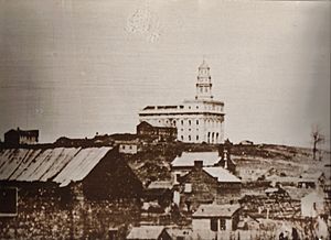
- Nauvoo – Nauvoo was the starting point for the Mormon trail. It had been the church's main center since 1839. In the 1840s, Nauvoo was almost as big as Chicago. Tensions grew between the Latter-day Saints and other local people. This led to the Saints being forced to leave. Brigham Young led his followers to Utah, which was not part of the United States at that time.
Iowa
- Sugar Creek (7 miles (11 km) west of Nauvoo) – The Latter-day Saints began gathering at Sugar Creek on February 4, 1846. This was after their first ferry crossing of the Mississippi River. Many more refugees kept crossing into Iowa for months. Some used the frozen Mississippi River a few weeks later. The unprepared travelers suffered from harsh winter weather while camped there. Sugar Creek was the starting area for the journey across Iowa. About 2,500 refugees and 500 wagons started west on March 1, 1846. Several thousand more followed later as they sold their property and left Nauvoo, Illinois.
- Richardson's Point (35 miles (56 km) west) – The travelers went past Croton and Farmington. They crossed the Des Moines River at Bonaparte. In early March 1846, heavy rain stopped the group for 10 days at Richardson's Point. Some of the first pioneers died at this spot.
- Chariton River Crossing (80 miles (129 km) west) – The trail continues past Troy, Drakesville, and West Grove to the Chariton River. At this crossing, on March 27, Young organized the main group of the migration. He formed three camps of 100 families, each with a captain. This military-style organization was used for all later Mormon groups.
- Locust Creek (103 miles (166 km) west) – The trail goes past Cincinnati to Locust Creek. There, on April 13, William Clayton, who wrote for Brigham Young, wrote "Come, Come Ye Saints." This is the most famous hymn from the Mormon Trail.
- Garden Grove (128 miles (206 km) west) – On April 23, the travelers arrived at their first semi-permanent settlement. They named it Garden Grove. They fenced and planted 715 acres (2.89 km2) to grow food for later travelers. They also built a village that still exists today. About 600 Latter-day Saints settled at Garden Grove. By 1852, they had moved on to Utah.
- Mount Pisgah (153 miles (246 km) west) – As they entered Potawatomi land, the travelers built another semi-permanent settlement called Mount Pisgah. Thousands of acres were farmed. About 700 Latter-day Saints lived there from 1846 to 1852. Today, a 9-acre (3.6 ha) park marks the site. It has exhibits, historical markers, and a rebuilt log cabin. Little remains from the 1800s except a cemetery. It honors the 300 to 800 travelers who died there.
- Nishnabotna River Crossing (232 miles (373 km) west) – From Mount Pisgah, the trail goes past Orient, Bridgewater, Massena, and Lewis. Just west of Lewis, the 1846 travelers passed a Potawatomi camp on the Nishnabotna River. The Potawatomis were also refugees; 1846 was their last year in the area.
- Grand Encampment (255 miles (410 km) west) – From the Nishnabotna River, the trail goes past Macedonia to Mosquito Creek. This is on the east side of present-day Council Bluffs. The first group arrived on June 13, 1846. At this open area, where the Iowa School for the Deaf is now, the LDS groups camped. This was called the Grand Encampment. From here, on July 20, the Mormon Battalion left for the Mexican–American War.
- Kanesville (later Council Bluffs) (265 miles (426 km) west) – The travelers built an important settlement and supply point here on the Missouri River. It was first called Miller's Hollow. The travelers renamed it Kanesville, honoring Thomas L. Kane. He was a non-LDS lawyer who helped the Latter-day Saints. From 1846 to 1852, it was an important LDS settlement and a place to get supplies for groups going to Utah. Orson Hyde, a church leader, published a newspaper called the Frontier Guardian. In 1852, the main LDS settlements at Kanesville, Mount Pisgah, and Garden Grove closed as settlers moved to Utah. After 1852, the Church still supplied groups (mostly new LDS members from the British Isles and Europe) at this community, now called Council Bluffs. This continued until the mid-1860s, when the First Transcontinental Railroad extended west.
Nebraska
- Winter Quarters (266 miles (428 km) west) – Brigham Young had planned to go all the way to the Salt Lake Valley in 1846. But the travelers were not ready, as seen during their hard trip across Iowa. Also, the Mormon Battalion leaving meant fewer men. Young decided to settle for the winter along the Missouri River. Travelers were on both sides of the river, but their settlement at Winter Quarters on the west side was the biggest. There, they built 700 homes where about 3,500 Latter-day Saints spent the winter of 1846–47. Many also stayed there during the winter of 1847–48. Sicknesses like scurvy and fever were common. The settlement recorded 359 deaths between September 1846 and May 1848. However, at Winter Quarters, the LDS travelers were able to get the equipment and supplies they needed to continue west. The settlement was later renamed Florence and is now in Omaha.
- Elkhorn River (293 miles (472 km) west)
- Platte River (305 miles (491 km) west) – All travelers leaving Missouri went along the Great Platte River Road for hundreds of miles. Many believed the north side of the river was healthier. So, most Latter-day Saints stayed on that side. This also kept them away from possible past enemies from Missouri or Illinois. In 1849, 1850, and 1852, there was so much traffic along the Platte that almost all grass was eaten on both sides of the river. The lack of food and risk of disease made the journey along the Platte very dangerous.
- Loup Fork (352 miles (566 km) west) – Crossing the Loup Fork, like the Elkhorn, was one of the first and very hard crossings from Council Bluffs.
- Fort Kearny (469 miles (755 km) west) – This fort, named after Stephen Watts Kearny, was built in June 1848. Another fort named after Kearny was built in May 1846 but was left in May 1848. Because of this, the second Fort Kearny is sometimes called New Fort Kearny. The land for the fort was bought from the Pawnee Indians for $2,000 in goods.
- Confluence Point (563 miles (906 km) west) – On May 11, 1847, a "roadometer" was put on Heber C. Kimball's wagon. This was about 3/4 mile (1.2 km) north of where the North and South Platte Rivers meet. Although they didn't invent the device, their measurements were accurate enough for William Clayton's famous Latter-day Saints' Emigrants' Guide.
- Ash Hollow (646 miles (1,040 km) west) – Many people writing in their diaries noted the beauty of Ash Hollow. However, thousands of passing travelers ruined it. The Sioux Indians were often there. General William S. Harney's troops won a battle against the Sioux there in September 1855 – the Battle of Ash Hollow. The site is also where many who died of cholera during the gold rush years are buried.
- Chimney Rock (718 miles (1,156 km) west) – Chimney Rock is perhaps the most important landmark on the Mormon Trail. Travelers wrote in their diaries that it looked closer than it was. Many drew or painted it in their journals and carved their names into it.
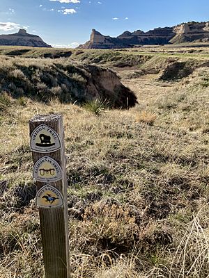
- Scotts Bluff (738 miles (1,188 km) west) – Hiram Scott was a trapper left on the bluff that now has his name. His friends left him when he got sick. Almost everyone who kept a journal on the north side of the Platte wrote about his death. The grave of Rebecca Winters, a Latter-day Saint mother who died of cholera in 1852, is also near this site. It has since been moved and rededicated.
Wyoming
- Fort Laramie (788 miles (1,268 km) west) – This old trading and military post was a place for travelers to rest and get more supplies. The 1856 Willie Handcart Company could not get supplies at Fort Laramie. This led to their later tragedy when they ran out of food in blizzards along the Sweetwater River.
- Upper Platte/Mormon Ferry (914 miles (1,471 km) west) – The last crossing of the Platte River was near modern Casper. For several years, the Latter-day Saints ran a ferry there. They earned money from travelers going to Oregon and California. The ferry stopped in 1853 after a competing toll bridge was built. On October 19, 1856, the Martin Handcart Company crossed the freezing river in mid-October. This caused many members of the company to get sick and die from exposure.
- Red Butte (940 miles (1,513 km) west) – Red Butte was the most tragic place on the Mormon Trail. After crossing the Platte River, the Martin Handcart Company camped near Red Butte as heavy snow fell. Snow kept falling for three days, and the company stopped as many travelers died. For nine days, the company stayed there, and 56 people died from cold or sickness. Finally, on October 28, three men from the Utah rescue party reached them. The rescuers told them help was coming and urged the company to start moving.
- Sweetwater River (964 miles (1,551 km) west) – From the last Platte crossing, the trail goes southwest toward Independence Rock. There, it meets and follows the Sweetwater River to South Pass. To make the journey shorter and avoid the river's twists, the trail crosses the river nine times.
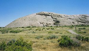
- Independence Rock (965 miles (1,553 km) west) – Independence Rock was one of the trail's most famous and awaited landmarks. Many travelers carved their names on the rock; many of these carvings are still visible today. The travelers sometimes celebrated their arrival here with a dance.
- Devil's Gate (970 miles (1,561 km) west) – Devil's Gate was a narrow gorge cut through rocks by the Sweetwater River. A small fort was at Devil's Gate. It was empty in 1856 when the Martin Handcart Company was rescued. The rescuers took unnecessary things off the wagons so the weaker handcart travelers could ride. A group of 19 men, led by Daniel W. Jones, stayed at the fort over the winter to protect the property.
- Martin's Cove (993 miles (1,598 km) west) – On November 4, 1856, the Martin Handcart Company camped in Martin's Cove. Another blizzard stopped their progress. They stayed there for five days until the weather improved. Then they could continue toward Salt Lake City. Today, a visitor center is at the site.
- Rocky Ridge (1,038 miles (1,670 km) west) – Between the fifth and sixth crossings of the Sweetwater, on October 19, 1856, the Willie Handcart Company was stopped by the same snowstorm that hit the Martin Handcart Company near Red Butte. At the same time, the Willie Company ran out of flour. A small advance team from the rescue party found their camp and gave them a little flour. But then they went east to find the Martin Company. Captain James Willie and Joseph Elder went ahead through the snow to find the main rescue party. They told them about the Willie Company's danger. On October 23, with the rescue party's help, the Willie Company pushed through the biting wind and snow up Rocky Ridge. This is a rough 5-mile (8.0 km) part of the trail that goes up a ridge to avoid a difficult section of the Sweetwater River valley.
- Rock Creek (1,048 miles (1,687 km) west) – After their very hard 18-hour trek up Rocky Ridge, the Willie Handcart Company camped at the Rock Creek crossing. That night, 13 travelers died. The next morning, their bodies were buried in a shallow grave.
- South Pass (Continental Divide) (1,065 miles (1,714 km) west) – South Pass is a 20-mile (32 km) wide pass across the Continental Divide. It is between the modern towns of Atlantic City and Farson. At 7,550 feet (2,301 m) above sea level, it was one of the most important landmarks on the Mormon Trail. Near South Pass is Pacific Springs. It got its name because its waters flow to the Pacific Ocean.
- Green River/Lombard Ferry (1,128 miles (1,815 km) west) – The trail crosses the Green River between the modern towns of Farson and Granger. The Latter-day Saints ran a ferry here to help church travelers and earn money from other travelers going to Oregon and California.
- Ft. Bridger (1,183 miles (1,904 km) west) – Fort Bridger was built in 1842 by famous mountain man Jim Bridger. This was where the paths of the Oregon Trail, the California Trail, and the Mormon Trail split. The three trails ran side-by-side from the Missouri River to Fort Bridger. In 1855, the LDS Church bought the fort from Jim Bridger and Louis Vazquez for $8,000. During the Utah War in 1857, the Utah militia burned down the fort. This was so it would not fall into the hands of the approaching U.S. Army under General A.S. Johnston.
- Bear River Crossing (1,216 miles (1,957 km) west) – At this, one of the last river crossings on the Mormon Trail, Lansford Hastings and his company turned north. The Reed–Donner Company turned south. Also here, the first company met mountaineer Miles Goodyear on July 10, 1847. He tried to convince them to take the northern path toward his trading post.
- The Needles (1,236 miles (1,989 km) west) – Near this very noticeable rock formation, close to the Utah–Wyoming border, Brigham Young became sick. It was likely Rocky Mountain spotted fever during the push into the Salt Lake Valley.
Utah
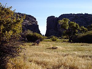
- Echo Canyon (1,246 miles (2,005 km) west) – This was one of the last canyons the travelers went through. This deep and narrow canyon made it a true echo chamber, which was often noted.
- Big Mountain (1,279 miles (2,058 km) west) – Even though it's smaller than the nearby Wasatch mountain peaks, this was the highest point of the entire Mormon trail at 8,400 feet (2,560 m).
- Golden Pass Road (1,281 miles (2,062 km) west) – Parley P. Pratt did not get funding from Salt Lake City. But he got the right to the canyon and began building a road through Big Canyon Creek in the Wasatch Mountains. This was just south of Emigration Canyon in July 1849. The canyon became known as Parley's Canyon. The road he built was called the "Golden Pass Road." This was because many gold miners used it on their way to California. A shortcut was built through Silver Creek Canyon by 1862. This moved much of the traffic to what is now the route of I-80.
- Emigration Canyon (Donner Hill) (1,283 miles (2,065 km) west) – About a year before the Latter-day Saint travelers, the Reed–Donner wagon train made the first road through the last natural barrier between Big Mountain and the Salt Lake Valley. About halfway through, the group changed course. They went up and around the final narrow part near the valley's entrance. The very hard climb over rock and sage likely contributed to the terrible tragedy that happened to those travelers three months and 600 miles (966 km) to the west. When a scouting team from the Latter-day Saint first company came through, they chose to stay on the valley floor. They cut their way through to the flat area overlooking the Great Salt Lake basin in less than four hours.
- Salt Lake Valley (1,297 miles (2,087 km) west) – The Salt Lake Valley had a special meaning for each traveler. It meant the end of more than a year of crossing the plains. But not all the pioneering Saints settled in the Salt Lake Valley. Settlements outside the Salt Lake Valley began as early as 1848. Many communities were started in the Weber valley to the north. Other town sites were carefully chosen. Settlements were placed near canyon mouths with access to reliable streams and forests. Latter-day Saints founded over 600 communities from Canada down into Mexico. As historian Wallace Stegner said, the Latter-day Saints "were one of the principal forces in the settlement of the West."
 | James Van Der Zee |
 | Alma Thomas |
 | Ellis Wilson |
 | Margaret Taylor-Burroughs |


