
Wasatch Range facts for kids
Quick facts for kids Wasatch Range |
|
|---|---|

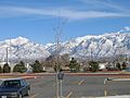
View of the Wasatch Range from the Salt Lake City Public Library, January 2006
|
|
| Highest point | |
| Peak | Mount Nebo |
| Elevation | 11,928 ft (3,636 m) |
| Geography | |
|
Lua error in Module:Location_map at line 420: attempt to index field 'wikibase' (a nil value).
|
|
| Country | United States |
| Parent range | Rocky Mountains |
The Wasatch Range (WAH-satch) or Wasatch Mountains is a long chain of mountains in the western United States. It stretches for about 160 miles (257 km) from the border of Utah and Idaho down into central Utah.
These mountains are the western edge of the larger Rocky Mountains. They also form the eastern edge of a big dry area called the Great Basin. A part of the Wasatch Range, known as the Bear River Mountains, reaches into Idaho.
The name "Wasatch" comes from the language of the native Ute people. It means "mountain pass" or "low pass over high range." Another idea is that it comes from a Shoshone leader named Wasattsi, which means "blue heron."
Contents
Living Near the Wasatch Mountains

For a long time, most people who moved to Utah chose to live along the western side of these mountains. This is because many rivers flow out of the mountains there. Early settlers used the mountains for water, wood, and strong rock called granite.
Today, about 85% of Utah's population lives very close to the Wasatch Range. They mostly live in the valleys just west of the mountains. This area is called the Wasatch Front, and over 2 million people live there. Salt Lake City is located between the Wasatch Range and the Great Salt Lake.

The highest point in the range is Mount Nebo. It stands 11,928 feet (3,636 meters) tall and has three peaks. It is located at the southern end of the range, near Nephi. In some places, the mountains rise very steeply from the valley floor.
Other famous peaks include Mount Timpanogos, which is huge and overlooks northern Utah County. You can see it clearly from Pleasant Grove and Orem. Lone Peak, the Twin Peaks, and Mount Olympus look over the Salt Lake Valley. Ben Lomond and Mount Ogden are both close to Ogden.

The Wasatch peaks are not as high as some other mountains in the Rocky Mountains, like those in Colorado. However, glaciers have carved them, making them look very rugged and beautiful. These mountains also get a lot of snow, sometimes more than 500 inches (1,270 cm) each year!
This heavy snowfall and the water from it have helped many cities grow along the mountains. The Wasatch Range has many ski resorts, with 11 of them stretching from Sundance in Utah County to Powder Mountain near Ogden. Park City alone has two ski resorts nearby.
The snow here is very dry and powdery. This is because of the low relative humidity and a special "lake-effect" from the Great Salt Lake. Ski resorts call it "the Greatest Snow on Earth." This amazing snow helped Salt Lake City host the 2002 Winter Olympics.
Some canyons, like Little Cottonwood Canyon, have great places for rock climbing on strong granite. Big Cottonwood Canyon also offers challenging climbing on quartzite rock.
Many narrow canyons in the Wasatch Range, like Big Cottonwood Canyon and Little Cottonwood Canyon, are very popular. They are close to downtown Salt Lake City. Paved roads go high up into the mountains, offering great views. Dirt roads also lead to high areas, reaching about 10,000 feet (3,048 meters) above sea level.
Mountain Geography and Geology


Mount Nebo, the highest peak, is at the southern end of the range. Here, the Colorado Plateau meets the southern part of the Rocky Mountains. To the west, the Great Basin begins, stretching across Utah and Nevada to the Sierra Nevada. The Wasatch Range has many faults, including the main Wasatch Fault. These faults also helped create the Timpanogos Cave.
The northern part of the Wasatch Range has several mountain valleys. The western side of the range drops sharply into the valleys where people live. But the eastern side is more gentle, which is why many ski resorts are built there.
The Cottonwoods, an especially rugged area east of Salt Lake Valley, have small mountain coves. These coves are home to four famous ski resorts: Alta, Brighton, Solitude, and Snowbird. The eastern slopes of the Cottonwoods lead down to the Snyderville Basin, where Park City and its two ski resorts are located.

North of Salt Lake City, the eastern side of the range is gentler. The range gets wider east of Ogden, creating a high mountain valley called the Ogden Valley. Three more ski resorts and small towns like Huntsville are found here.
Further north, the Wellsville Mountains branch off. They are very thin and steep. Cache Valley, formed by the Bear River, is surrounded by the Wellsville Mountains to the west and the taller Bear River Mountains to the east. The highest peaks in this area are Mount Naomi and Mount Logan, both almost 10,000 feet (3,048 meters) tall.

The southeastern part of the range in Wasatch County turns into the flat Wasatch Plateau. This plateau is about 8,500 to 9,500 feet (2,591 to 2,896 meters) high. The Heber Valley and Weber River Valley separate the Wasatch Range from the Uinta Mountains.
Only seven main highways cross the Wasatch Range. Two important ones are I‑80 through Parley's Canyon east of Salt Lake City, and I‑84 through Weber Canyon southeast of Ogden. They meet near the old town of Echo. Other highways include US‑6 through Spanish Fork Canyon and US‑189 through Provo Canyon.
A train line, once owned by the Denver and Rio Grande Western Railroad, also goes through the Wasatch Range. It passes through Soldier Summit Pass and Spanish Fork Canyon. Today, Union Pacific Railroad uses this line for freight trains and Amtrak's California Zephyr passenger train.
Plants and Animals
The Wasatch Range is part of a large area called the Wasatch and Uinta Mountains Ecoregion. This is a temperate coniferous forest, meaning it has many cone-bearing trees. Common trees include Douglas fir, subalpine fir, Engelmann spruce, Colorado blue spruce, and quaking aspen.
You can find Gambel oak trees on the lower hills of the range, from south of Brigham City to the southern end. This type of oak is not found in the very northern part of the range. Ponderosa pine trees are not very common here, except in planted areas.
Different types of big sagebrush plants cover the drier parts of the landscape. Most of it is mountain big sagebrush. Some valley bottoms used to have basin big sagebrush, but much of it was removed for farming. All types of sagebrush provide important homes for animals like the greater sage grouse.
The Wasatch Range is also home to several plants that grow nowhere else in the world. Some of these are very rare. Examples include five-petal cliffbush, Sierra fumewort, and Utah angelica.
Fun Activities and Recreation

Besides the many ski resorts, the Wasatch Range has hundreds of miles of trails. These trails are great for mountain biking and hiking through the canyons and mountain valleys. They offer a chance to explore the backcountry close to a big city.
You can also go rock climbing and mountaineering on the tall peaks made of limestone, granite, and quartzite. In winter, people enjoy ski touring, ski mountaineering, and snowshoeing.
The mountain lakes and streams offer some fishing, though they are quite popular. The Wasatch Mountain Club organizes many outdoor activities. The Utah Native Plant Society leads walks to see wildflowers from spring to fall. Many beautiful wildflowers bloom in late summer in Albion Basin, at the top of Little Cottonwood Canyon.

Images for kids
-
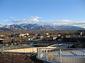
View of the Wasatch Range from the Salt Lake City Public Library, January 2006
-
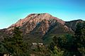
Mount Olympus, a prominent and recognizable mountain visible from much of the Salt Lake Valley, August 2005
-
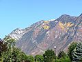
The Wasatch Mountains in the fall, September 2003
-
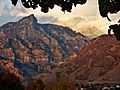
Squaw Mountain over Rock Canyon at sunset as seen from the campus of Brigham Young University in Provo, August 2012.
-
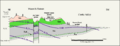
Wasatch Plateau geologic cross section, where Kmt and Kmf are the Tununk and Ferron Sandstone members of the Mancos Shale, Km. Kmv is the Mesaverde Group and Tkn is the North Horn Formation
-
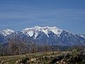
West side of Mount Nebo, the highest peak in the Wasatch Range.
-
The Wasatch Range viewed from Jordan Campus of Salt Lake Community College, March 2006
-
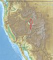
The western United States with the Wasatch Range outlined in red.
-
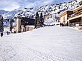
Alta ski resort in Little Cottonwood Canyon, February 2009
See also
 In Spanish: Cordillera Wasatch para niños
