Huntsville, Utah facts for kids
Quick facts for kids
Huntsville, Utah
|
|
|---|---|

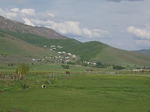
The eastern part of Huntsville
|
|
| Nickname(s):
McKayville
|
|

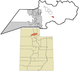
Location in Weber County and the state of Utah
|
|
| Country | United States |
| State | Utah |
| County | Weber |
| Founded | 1860 |
| Incorporated | 1924 |
| Founded by | Jefferson Hunt |
| Area | |
| • Total | 0.89 sq mi (2.30 km2) |
| • Land | 0.83 sq mi (2.15 km2) |
| • Water | 0.06 sq mi (0.15 km2) |
| Elevation | 4,931 ft (1,503 m) |
| Population
(2010)
|
|
| • Total | 608 |
| • Estimate
(2019)
|
642 |
| • Density | 774.43/sq mi (299.13/km2) |
| Time zone | UTC-7 (Mountain (MST)) |
| • Summer (DST) | UTC-6 (MDT) |
| ZIP code |
84317
|
| Area code(s) | 385, 801 |
| FIPS code | 49-37060 |
| GNIS feature ID | 1428949 |
Huntsville is a small town in Weber County, Utah, United States. In 2010, about 608 people lived there. It is located in a beautiful area called Ogden Valley. Huntsville is part of a larger group of towns known as the Ogden–Clearfield, Utah Metropolitan Area.
Contents
History of Huntsville
Founding and Early Days
Huntsville was started in 1860 by a person named Jefferson Hunt. It quickly became a small community.
Important People and Places
In 1877, a local church group was formed. Francis Hammond was its first leader. Later, David McKay took over in 1885. His son, also named David O. McKay, later became a very important leader of the Church of Jesus Christ of Latter-day Saints.
A special kind of monastery, called the Abbey of Our Lady of the Holy Trinity, was built in Huntsville in 1947. Monasteries are places where religious people live and work together. This one closed after 70 years in 2017.
The Shooting Star Saloon
Huntsville is also home to a very old place called the Shooting Star Saloon. It opened in 1879 and is known as the oldest bar that has been open continuously west of the Mississippi River. People love its special "Star Burger." This burger has two meat patties, cheese, a type of sausage called Polish knackwurst, and bacon.
Geography and Climate
Where is Huntsville Located?
Huntsville is a small town. According to the United States Census Bureau, it covers about 0.7 square miles (1.9 square kilometers). Most of this area is land, but a small part is water.
Huntsville's Weather
Huntsville has a type of weather called a humid continental climate. This means it has big changes in temperature throughout the year. Summers can be warm to hot, and sometimes humid. Winters are cold, and can even be very cold.
| Climate data for Huntsville, Utah, 1991–2020 normals, 1976-2020 extremes: 5140ft (1567m) | |||||||||||||
|---|---|---|---|---|---|---|---|---|---|---|---|---|---|
| Month | Jan | Feb | Mar | Apr | May | Jun | Jul | Aug | Sep | Oct | Nov | Dec | Year |
| Record high °F (°C) | 57 (14) |
62 (17) |
77 (25) |
86 (30) |
93 (34) |
97 (36) |
102 (39) |
102 (39) |
95 (35) |
88 (31) |
73 (23) |
64 (18) |
102 (39) |
| Mean maximum °F (°C) | 48.5 (9.2) |
52.3 (11.3) |
65.3 (18.5) |
76.4 (24.7) |
84.6 (29.2) |
92.7 (33.7) |
96.6 (35.9) |
95.5 (35.3) |
89.5 (31.9) |
80.6 (27.0) |
64.1 (17.8) |
50.3 (10.2) |
97.4 (36.3) |
| Mean daily maximum °F (°C) | 34.2 (1.2) |
40.7 (4.8) |
51.2 (10.7) |
60.3 (15.7) |
71.3 (21.8) |
81.9 (27.7) |
90.1 (32.3) |
89.1 (31.7) |
79.2 (26.2) |
64.3 (17.9) |
47.7 (8.7) |
35.0 (1.7) |
62.1 (16.7) |
| Daily mean °F (°C) | 22.6 (−5.2) |
27.8 (−2.3) |
37.6 (3.1) |
45.5 (7.5) |
54.2 (12.3) |
62.2 (16.8) |
69.5 (20.8) |
68.2 (20.1) |
59.3 (15.2) |
47.2 (8.4) |
34.8 (1.6) |
23.8 (−4.6) |
46.1 (7.8) |
| Mean daily minimum °F (°C) | 10.9 (−11.7) |
14.9 (−9.5) |
24.0 (−4.4) |
30.7 (−0.7) |
37.2 (2.9) |
42.6 (5.9) |
48.9 (9.4) |
47.3 (8.5) |
39.3 (4.1) |
30.2 (−1.0) |
22.0 (−5.6) |
12.7 (−10.7) |
30.1 (−1.1) |
| Mean minimum °F (°C) | −9.6 (−23.1) |
−8.2 (−22.3) |
4.1 (−15.5) |
16.7 (−8.5) |
23.7 (−4.6) |
30.5 (−0.8) |
38.4 (3.6) |
36.0 (2.2) |
26.0 (−3.3) |
16.3 (−8.7) |
0.4 (−17.6) |
−7.4 (−21.9) |
−15.1 (−26.2) |
| Record low °F (°C) | −33 (−36) |
−34 (−37) |
−17 (−27) |
0 (−18) |
16 (−9) |
24 (−4) |
31 (−1) |
23 (−5) |
18 (−8) |
9 (−13) |
−16 (−27) |
−37 (−38) |
−37 (−38) |
| Average precipitation inches (mm) | 2.76 (70) |
2.19 (56) |
2.00 (51) |
1.90 (48) |
2.14 (54) |
1.34 (34) |
0.69 (18) |
0.78 (20) |
1.31 (33) |
1.79 (45) |
1.80 (46) |
2.44 (62) |
21.14 (537) |
| Average snowfall inches (cm) | 22.50 (57.2) |
17.40 (44.2) |
7.20 (18.3) |
3.10 (7.9) |
0.30 (0.76) |
0.00 (0.00) |
0.00 (0.00) |
0.00 (0.00) |
0.00 (0.00) |
1.80 (4.6) |
7.30 (18.5) |
22.80 (57.9) |
82.4 (209.36) |
| Source 1: NOAA | |||||||||||||
| Source 2: XMACIS2 (records & monthly max/mins) | |||||||||||||
People of Huntsville
Population Changes Over Time
| Historical population | |||
|---|---|---|---|
| Census | Pop. | %± | |
| 1870 | 1,051 | — | |
| 1880 | 819 | −22.1% | |
| 1890 | 1,158 | 41.4% | |
| 1900 | 1,022 | −11.7% | |
| 1910 | 906 | −11.4% | |
| 1920 | 814 | −10.2% | |
| 1930 | 520 | −36.1% | |
| 1940 | 496 | −4.6% | |
| 1950 | 494 | −0.4% | |
| 1960 | 552 | 11.7% | |
| 1970 | 553 | 0.2% | |
| 1980 | 577 | 4.3% | |
| 1990 | 561 | −2.8% | |
| 2000 | 649 | 15.7% | |
| 2010 | 608 | −6.3% | |
| 2019 (est.) | 642 | 5.6% | |
| U.S. Decennial Census | |||
In 2000, there were 649 people living in Huntsville. The town had 194 households, which are groups of people living together. Most of these were families.
Who Lives in Huntsville?
About 46% of the households in Huntsville had children under 18 living there. Most households (70.6%) were married couples living together. About 10% were female householders without a husband present.
The average household had about 3.35 people. The average family had about 3.70 people.
Age Groups in Town
The population of Huntsville is spread out across different age groups.
- About 33.7% of the people were under 18 years old.
- About 11.1% were between 18 and 24 years old.
- About 21.4% were between 25 and 44 years old.
- About 21.9% were between 45 and 64 years old.
- About 11.9% were 65 years old or older.
The average age in Huntsville was 34 years. For every 100 females, there were about 108.7 males.
Government Representation
Huntsville is part of Utah's First Congressional District. This means that the people of Huntsville, along with others in this district, choose a person to represent them in the United States Congress. Currently, this representative is Blake Moore, who is a member of the Republican Party. He is from Ogden.
Gallery
-
Snowbasin Ski Area from Huntsville
See also
 In Spanish: Huntsville (Utah) para niños
 | Valerie Thomas |
 | Frederick McKinley Jones |
 | George Edward Alcorn Jr. |
 | Thomas Mensah |


