
Clearfield, Utah facts for kids
Quick facts for kids
Clearfield, Utah
|
|
|---|---|
|
City
|
|

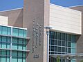
Clearfield City Municipal and Justice Center
|
|
| Motto(s):
We’ve Got it Made
|
|

Location in Davis County and the state of Utah.
|
|
| Country | United States |
| State | Utah |
| County | Davis |
| Settled | 1877 |
| Incorporated | July 17, 1922 |
| Incorporated (city) | March 21, 1946 |
| Founded by | Richard Hamblin |
| Area | |
| • Total | 7.74 sq mi (20.06 km2) |
| • Land | 7.71 sq mi (19.98 km2) |
| • Water | 0.03 sq mi (0.08 km2) |
| Elevation | 4,442 ft (1,354 m) |
| Population
(2020)
|
|
| • Total | 31,909 |
| • Density | 4,122.6/sq mi (1,590.7/km2) |
| Time zone | UTC−7 (Mountain (MST)) |
| • Summer (DST) | UTC−6 (MDT) |
| ZIP codes |
84015, 84016, 84089
|
| Area codes | 385, 801 |
| FIPS code | 49-13850 |
| GNIS feature ID | 2409478 |
| Website | https://clearfield.city/ |
Clearfield is a city in Davis County, Utah, United States. Its name in the Shoshone language means "Place where the wind blows hard." In 2020, about 31,909 people lived here.
Clearfield grew quickly in the 1940s because of Hill Air Force Base. It kept growing in the 1950s as more people moved to suburbs. Since then, the city has continued to get bigger. Clearfield is a main city in the Ogden-Clearfield metropolitan area, which includes Davis, Morgan, and Weber counties.
Contents
History of Clearfield
Early Days and Growth
Clearfield was one of the last places settled in northern Davis County, starting in 1877. Before settlers arrived, hunters and Native American warriors knew this area. They called it the "land of wind and sand."
The railroad came in 1869, which began to change the area. It was once known as Sand Ridge before its name became Clearfield. Early families had to bring water from Kays Creek in East Layton. This was because they couldn't dig successful wells at first.
A big change happened in 1884 with the Davis and Weber Counties Canal. This canal brought much-needed water. It caused a quick population boom. People started to farm the land, turning the sandy area into fertile gardens. Homes and farms soon appeared everywhere.
Schools and Military Bases
Many Clearfield children first walked several miles to school in Syracuse. In 1907, the new Clearfield Elementary School opened. It taught students from first to eighth grade. The school burned down in 1923, but a new building, later called Pioneer School, replaced it.
North Davis Junior High School opened in 1939. It cost about $170,000 to build. In its first year, it had 18 teachers and 585 students. For many years, Clearfield was a quiet farming town.
However, the addition of military bases changed things. Construction on Hill Field (now Hill Air Force Base) began in 1940. This base is along Clearfield's eastern border. It has provided many jobs for people and is a major employer in Utah.
In 1943, the U.S. Navy built the Clearfield Naval Supply Depot. Clearfield was a good spot for it because it was safe from attacks. It also had nearby air transport at Hill Air Force Base. Plus, railroads and highways were close by. The dry climate was perfect for storage, and there were plenty of workers.
As the population grew, more schools were needed. South Clearfield Elementary opened in 1950. In 1959, Clearfield High School opened. It was the first high school in northern Davis County.
Modern Developments
The Clearfield Naval Supply Depot closed by 1962. But the buildings didn't stay empty for long. Private companies moved in, and the area became known as the Freeport Center. Today, it's a big hub for making, storing, and distributing goods in the western U.S.
Hill Field Elementary opened in 1963, west of Hill Air Force Base. The Clearfield Job Corps Center started in 1966. It's located west of the Freeport Center. This center helps young people aged 16-24 get training and jobs.
Clearfield City got a new city hall building in 1969. A modern Clearfield Fire Station opened in 1980, next to city hall. Holt Elementary opened in 1981 in the city's northwest corner.
The newest Clearfield City Municipal Building opened in December 1999. Legend Hills, a large office and shopping area, began in 2002. It's on the city's east side, near Interstate 15.
In 2004, work began on the Clearfield Aquatic Center. The old swimming pool was taken down in 2005 to make way for it. A new skate park was also added to Bernard Fisher Park that year. The Aquatic Center opened in 2005. It's next to the new North Davis Junior High, which replaced the old one. An outdoor splash pad was added to the Aquatic Center in 2006.
Clearfield High School was updated in 2006. This included its main auditorium and computer systems. In 2008, the Utah Transportation Association (UTA) FrontRunner train stop opened in Clearfield. This helped the city become a central place for business and community activities.
In 2010, Davis County opened a new office building for its Health Department. The Heritage Senior Activity Center moved and reopened as the North Davis Senior Center in 2011. In 2012, the Clearfield Community Center became the Clearfield Community Arts Center. It's now a place for art classes and theater shows.
Geography and Climate
Location and Landscape
Clearfield City covers about 7.8 square miles (20.06 km2) of land. In 2020, it had 31,909 people, making it the fifth-largest city in Davis County. This means there are about 3,860 people per square mile. Clearfield is about 4,327 feet (1,319 meters) above sea level.
The city is in the north-central part of Davis County. The Great Salt Lake is to the west, and the Wasatch Range mountains are to the east. Clearfield is surrounded by other cities like Sunset, Clinton, Syracuse, West Point, and Layton. Hill Air Force Base is also nearby.
There are no big lakes or rivers in Clearfield. There are a few small ponds in parks. The main waterway is the Weber and Davis Canal on the city's eastern side. The Clearfield Canal Trail runs along part of this canal. The Great Salt Lake is separated from Clearfield by marshlands. Sometimes, the lake can smell like sulfur for a few hours due to bacteria.
From Clearfield, you can see tall mountains. These include Deseret Peak, Ben Lomond Peak, and Thurston Peak. The Wasatch Fault runs along the base of the Wasatch Range. Scientists believe a large earthquake could happen there.
Clearfield is built on the old lakebed of Lake Bonneville. This huge lake existed at the end of the last ice age. You can still see the old shorelines of Lake Bonneville on the nearby mountains.
City Layout and Neighborhoods
Clearfield's streets, like many in Davis County, follow a grid plan. Most main streets run north-south and east-west. Clearfield is the easternmost city on this grid.
Clearfield has several neighborhoods, many of which are for businesses. In the southwest, there's a large business area called The Freeport Center. The Clearfield Job Corps is also there. Being next to the Freeport Center helps Job Corps students get on-the-job training. The Freeport Center used to be the Clearfield Naval Supply Depot.
South Clearfield is a residential neighborhood. It's a bit separate from the rest of Clearfield. This is because it's surrounded by the Freeport Center and other businesses.
Two business areas are linked to Hill Air Force Base. Falcon Hill is a planned development on the base's west side. It will be an aerospace research complex. Legend Hills is another business area in the southeast corner of the city. It has many offices and shops. Both areas are easy to reach from Interstate 15.
Weather Patterns
Clearfield has a humid continental climate with four distinct seasons. Summers are long, hot, and dry. Winters are cold and snowy. Spring and fall are shorter, pleasant times in between.
The city gets about 20.75 inches (527 mm) of rain and snow each year. Spring is the wettest season, especially May. Summers are very dry. Snow usually falls from November to April, with about 24 inches (61 cm) yearly.
Most of Clearfield's rain and snow comes from big Pacific storms. These storms move in from the Pacific Ocean from October to May. Sometimes, it can snow as early as September or as late as May. In summer, rain comes from afternoon thunderstorms. These storms are caused by moisture from the Gulf of California. While they can bring heavy rain, they are usually scattered.
Temperatures in Clearfield change a lot between seasons. July is the hottest month, and January is the coldest. The average yearly temperature is about 53°F (12°C). The hottest temperature ever recorded was 108°F (42°C) in July 2002. The coldest was -26°F (-32°C) in January 1937.
In winter, high pressure can cause temperature inversions. This traps cold air and pollution in the valley. It can lead to thick smog and unhealthy air quality for days or weeks. Other severe weather is rare, except for heavy snows in winter.
Population in Clearfield
| Historical population | |||
|---|---|---|---|
| Census | Pop. | %± | |
| 1900 | 640 | — | |
| 1910 | 791 | 23.6% | |
| 1920 | 658 | −16.8% | |
| 1930 | 799 | 21.4% | |
| 1940 | 982 | 22.9% | |
| 1950 | 4,723 | 381.0% | |
| 1960 | 8,833 | 87.0% | |
| 1970 | 13,316 | 50.8% | |
| 1980 | 17,982 | 35.0% | |
| 1990 | 21,435 | 19.2% | |
| 2000 | 25,974 | 21.2% | |
| 2010 | 30,122 | 16.0% | |
| 2020 | 31,909 | 5.9% | |
| U.S. Decennial Census | |||
The table above shows how Clearfield's population has grown over the years. In 2020, there were 31,909 people living in 10,343 homes in Clearfield.
Clearfield's Economy
Clearfield is home to many important employers in Utah and Davis County. These include:
- Hill Air Force Base
- Lifetime Products
- Utility Trailer Manufacturing Company
- Alliant Techsystems
- Clearfield Job Corps
- Futura Industries Corporation
- Smith Sport Optics, Inc.
Freeport Center
The Freeport Center is a large hub for making, storing, and distributing goods. Over 70 national and local companies are located here. Together, they employ more than 7,000 people. The Freeport Center has great connections to highways and railroads. It's also only 20 miles from the Salt Lake International Airport.
Legend Hills
Legend Hills is an office and business area in northern Davis County. It's on the east side of Clearfield, right next to Interstate 15.
Notable People from Clearfield
- Haven J. Barlow (born in Clearfield), a politician.
- Nolan Bushnell (born in Clearfield), an engineer and entrepreneur who started Atari, Inc and Chuck E. Cheese's Pizza-Time Theaters.
- Shonduras, a businessman.
- Dallon Weekes, a musician. He is the only permanent member of the band The Brobecks and played bass for Panic! at the Disco.
See also
 In Spanish: Clearfield (Utah) para niños
Images for kids
-
Clearfield Aquatic Center, built in 2006
-
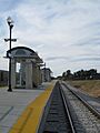
Clearfield City FrontRunner UTA Station
-
Clearfield City pole at UTA station


