Great Salt Lake facts for kids
Quick facts for kids Great Salt Lake |
|
|---|---|

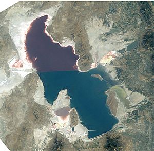
Satellite photo from August 2003 after five years of drought, reaching near-record lows. Note the difference in colors between the Northern and Southern portions of the lake, the result of a railroad causeway.
|
|
| Location | Utah, United States |
| Coordinates | 41°10′N 112°35′W / 41.167°N 112.583°W |
| Type | Endorheic, hypersaline, generally 27% salinity |
| Primary inflows | Bear, Jordan, Weber rivers |
| Catchment area | 21,500 sq mi (56,000 km2) |
| Basin countries | United States |
| Max. length | 75 mi (121 km) |
| Max. width | 28 mi (45 km) |
| Surface area | 1,700 sq mi (4,400 km2) |
| Average depth | 16 ft (4.9 m), when lake is at average level |
| Max. depth | 33 ft (10 m) average, high of 45 ft (14 m) in 1987, low of 24 ft (7.3 m) in 1963 |
| Water volume | 15,338,693.6 acre⋅ft (18.92 km3) |
| Surface elevation | historical average of 4,200 ft (1,300 m), 4,196.6 ft (1,279.1 m) as of 2006 August 24 |
| Islands | 8-15 (variable, see Islands) |
| Settlements | Salt Lake and Ogden metropolitan areas. |
The Great Salt Lake is a huge saltwater lake located in the state of Utah, United States. It's a special kind of lake called an endorheic lake. This means that water flows into it, but it doesn't have any rivers flowing out to the ocean. Instead, water leaves the lake mostly by evaporation.
Because water evaporates and leaves its salt behind, the Great Salt Lake is much saltier than the ocean. It's one of the biggest endorheic lakes in the world. The lake is found in the Great Basin, which is a large desert area covering parts of several U.S. states.
Contents
Discover the Great Salt Lake
The Great Salt Lake is about 75 miles (121 km) long and 28 miles (45 km) wide. Its size can change a lot because it's in a desert. When there's more rain, the lake gets bigger. When it's dry, it shrinks.
How Salty Is This Lake?
The lake's average surface area is about 1,700 square miles (4,400 km2). It is many times saltier than the world's oceans, sometimes up to 27% salt! This high salt content is why it's sometimes called "America's Dead Sea," similar to the famous Dead Sea in Asia.
Three main rivers flow into the lake: the Jordan, Weber, and Bear rivers. These rivers bring fresh water, but the salt stays behind when the water evaporates.
Amazing Animals and Nature
Even though it's super salty, the Great Salt Lake is a busy home for many animals. It's a very important habitat for millions of birds. These birds stop here during their long migrations.
You can also find tiny shrimp called brine shrimp living in the lake. These shrimp can handle the very salty water. They are a main food source for many of the birds that visit the lake. The lake's unique environment supports a surprising amount of life.
Where is the Lake Located?
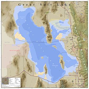
The Great Salt Lake touches several counties in Utah. These include Davis, Tooele, Box Elder, Salt Lake, and Weber counties. The big cities of Salt Lake and Ogden are also nearby.
Images for kids
-
Stansbury's 1852 map of the Great Salt Lake and adjacent country in the Utah Territory
-
Great Salt Lake from airspace over Salt Lake City
-
Sunset viewed from White Rock Bay, on the western shore of Antelope Island. Carrington Island is visible in the distance.
-
American avocets at Bear River Migratory Bird Refuge
See also
 In Spanish: Gran Lago Salado para niños
 | Leon Lynch |
 | Milton P. Webster |
 | Ferdinand Smith |


