Tooele County, Utah facts for kids
Quick facts for kids
Tooele County
|
|
|---|---|
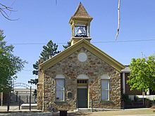
Tooele County Courthouse and City Hall in Tooele, Utah.
|
|
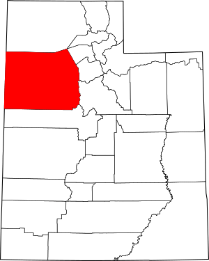
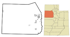
Location within the U.S. state of Utah
|
|
 Utah's location within the U.S. |
|
| Country | |
| State | |
| Founded | January 31, 1850 (created) June 10, 1851 (organized) |
| Seat | Tooele |
| Largest city | Tooele |
| Area | |
| • Total | 7,286 sq mi (18,870 km2) |
| • Land | 6,941 sq mi (17,980 km2) |
| • Water | 345 sq mi (890 km2) 4.7% |
| Population
(2020)
|
|
| • Total | 72,698 |
| • Estimate
(2023)
|
82,051 |
| • Density | 9.9778/sq mi (3.85244/km2) |
| Time zone | UTC−7 (Mountain) |
| • Summer (DST) | UTC−6 (MDT) |
| Congressional district | 2nd |
Tooele County (/tuːˈwɪlə/ too-WIL-ə) is a county in the U.S. state of Utah. In 2020, about 72,698 people lived there. Its main city and county seat is Tooele. The county was officially created in 1850 and started its government in 1851.
Tooele County is part of the larger Salt Lake City metropolitan area. In 2008, a study found that Tooele County had the most job growth in the U.S. since the year 2000.
The western part of the county is mostly covered by the Great Salt Lake Desert. This area includes the city of Wendover and the town of Ibapah. In the middle of the county is Skull Valley, located between the Cedar and Stansbury Mountains. It has a few small towns and the Dugway Proving Ground, a special testing area.
Most people live on the eastern side in the Tooele Valley. This valley is between the Stansbury and Oquirrh Mountains. Here you'll find cities like Tooele, Grantsville, Erda, and Lake Point. The Tooele Army Depot, a military base, is at the southern end of the valley.
The Stockton Bar is a natural land feature that separates Tooele Valley from Rush Valley. In Rush Valley, you can find towns like Stockton, Vernon, Faust, and Rush Valley. There are also small towns like Ophir and Mercur in canyons on the southwest side of the Oquirrh Mountains.
Tooele County is also home to a campus of Utah State University. This university has nine campuses across Utah, and one is in the city of Tooele.
Contents
History of Tooele County
Long ago, several Native American groups lived in Tooele County. However, only the Goshute tribe, who speak the Shoshone language, consider these lands their true home. Their traditional lands covered most of what is now Tooele County.
In 1846, a group of pioneers known as the Donner-Reed Party faced a huge challenge crossing the Great Salt Lake Desert. This desert, which covers much of the northern part of the county, made their wagons move very slowly. It took them six days to cross 80 miles, which used up a lot of their supplies. This struggle contributed to their later difficulties.
In 1847, Mormon pioneers settled in the nearby Salt Lake Valley. At first, Tooele Valley was mainly used by Mormon cattle owners from Salt Lake and Utah Valleys for grazing their animals. In 1849, the first white settlers built homes in Tooele Valley. They built a saw mill and called their settlement E.T. City.
On January 31, 1850, the government of the Utah Territory officially created Tooele County. It was first called "Tuilla" and had different borders than it does today. Its government wasn't set up yet, so it was managed by Salt Lake County. People think the name "Tooele" might come from a Native American chief. Other ideas are that it comes from "tu-wanda", a Goshute word for "bear", or from "tule", a Spanish word for "bulrush".
The Goshutes did not like the Mormons moving onto their traditional lands. The Mormons used the best camping spots near water, hunted in Goshute hunting areas, and let their cattle eat too much grass. This made it hard for the Goshutes to find food and plants they needed. The Mormons believed Utah was a special land given to them by God and didn't think the Goshutes had a claim to it.
The Goshutes started taking Mormon cattle that went onto their land. In response, the Mormons sent their armies to fight the Goshutes. In 1850, they attacked a Goshute village. Later that year, more than 50 men attacked a Goshute camp, and several Goshutes were killed. In 1851, General Daniel H. Wells took 30 Goshutes prisoner, and they later died. Similar conflicts happened throughout the 1850s, with the Goshutes often suffering losses.
By June 10, 1851, Tooele County's own government was set up. By 1852, other towns like Grantsville, Batesville, and Pine Canyon (later called Lincoln) were settled.
In 1855, Richville was chosen as the county seat. But it soon became clear that Tooele was much bigger. So, in 1861, the county chose Tooele as its new county seat.
In 1859, a U.S. government representative named Robert B. Jarvis tried to help some Goshute groups settle at a farm reservation called Deep Creek. This seemed promising, but when Jarvis left in 1860, the farm was abandoned. His replacement, Benjamin Davies, saw that the Goshutes no longer trusted the government. He suggested limiting how much more land settlers took from the Goshutes, but his ideas were mostly ignored.
Twenty-two outposts for stagecoaches were built in Goshute territory. These were often located near rare natural springs. Goshute attacks on these outposts increased in 1860. When the American Civil War started, federal troops left the area. The local defense was handled by the Nauvoo Legion until General Patrick E. Connor arrived in Salt Lake City in 1862.
General Connor was very tough with the Native Americans. In 1863, he attacked Native American camps, sometimes without checking who was there. By 1863, stagecoach companies had lost many men and horses to these attacks. A peace treaty was signed in 1863. This treaty gave the Goshutes some goods and money for game that was killed. In return, the Goshutes agreed to stop fighting and allow routes through their lands. The treaty did not give away Goshute land, but a later agreement in 1865 did.
General Connor also encouraged his soldiers to look for minerals. He believed that mining would bring more non-Mormon people to Utah. He was right! In 1864, his men found gold, silver, lead, and zinc in Tooele County. The Rush Valley Mining District was started by soldiers, and over 100 mining claims were made in the first year. Two new mining towns, Ophir and Lewiston, grew very quickly. By the 1870s, each had over 6,000 people, which was more than Tooele and other Mormon settlements.
Tooele County's original borders extended into what is now Nevada. The county's boundaries were changed several times between 1852 and 1862. When Nevada Territory was created in 1862 and became a state in 1864, Tooele County officially lost all its land in Nevada. After two more boundary changes in 1870 and 1880, the county's borders have stayed the same.
The "Republic of Tooele"
From 1874 to 1879, a political group called the Liberal Party of Utah gained control of Tooele County. This was the first time non-Mormon politicians had success in Utah. They jokingly called the county the "Republic of Tooele."
The Liberal Party, which started in 1870, saw that many non-Mormon miners lived in Tooele County. They thought this would help them win elections. They campaigned hard in the mining areas before the June 1874 election. The governor of Utah Territory, George L. Woods, who was not Mormon, also campaigned for the Liberal Party in Tooele County.
The other main political group, the Mormon People's Party, watched the voting places closely. After the Liberal Party won by about 300 votes, the People's Party complained that there had been cheating. They said that some Liberal Party supporters voted more than once, or hadn't lived in the county long enough, or didn't pay taxes (which was required to vote back then). They pointed out that 2,200 votes were cast, but only 1,500 people in Tooele County paid property taxes.
The governor ignored these complaints and said the Liberal Party had won. A judge also ruled that there was no proof of illegal activity. The People's Party members who held county offices refused to leave the county recorder's office and the Tooele County Courthouse.
The governor and judge then ordered U.S. Marshals to put the Liberal candidates in charge. The recorder's office was taken when it was empty. But a group of People's Party supporters stayed inside the courthouse day and night. The marshals and Liberal Party candidates were outnumbered and tried to talk with the Mormons inside. Everyone knew that a fight could start, so they tried to find a peaceful solution.
Finally, the judge issued a very strong order. Brigham Young, a leader of the Mormons, told his followers they should obey the federal courts. The county courthouse was then left empty, and the Liberal Party took control for about five years. However, the Utah territorial legislature, which decided who could be a member, refused to let the Liberal Party representative from Tooele County join.
The Liberal Party won the 1876 election without anyone running against them.
In 1876, the territorial legislature passed new laws. One required people to register to vote, and another allowed women to vote in local elections (women had been voting in territorial elections since 1870). The Liberal Party, which was mostly supported by male miners, did not like these new rules. By 1878, the Liberal Party's support in Tooele County had gone down. In 1879, the People's Party regained control after the Liberal Party tried to delay things for over six months.
People later said that the "Republic of Tooele" era spent too much money. The county ended up with about $16,000 in debt, which was much more than it had before.
Modern Tooele County
Mining continued to be important in Tooele County into the 1900s. The county also benefited from two large military bases. Wendover Air Force Base, which is now closed, was where the crew of the Enola Gay trained. This plane dropped the first atomic weapon in 1945. The Tooele Army Depot, built in 1942, used to store a large amount of chemical and biological weapons. Starting in 1996, these weapons were destroyed in a special incinerator, and the last one was destroyed in 2012.
Since the 1980s, much of Tooele County's economy has involved private facilities that handle certain kinds of waste. These facilities have been built in places like Clive and Aragonite. Because of this, and the history of military storage, some people have seen Tooele County as a place where unwanted materials are sent.
News about the county is shared by the Tooele Transcript-Bulletin newspaper.
On September 8, 2004, the Genesis spacecraft crashed in the desert at the Dugway Proving Ground in Tooele County.
The western part of the county is home to the Bonneville Salt Flats. This famous area is crossed by Interstate 80.
Geography
Tooele County is located on the west side of Utah. Its western border touches the state of Nevada. To the northeast, it borders the Great Salt Lake. Three important mountain ranges run north to south through the county. The eastern border of the county is along the top of the Oquirrh Mountains. These mountains separate Tooele Valley from Salt Lake Valley. The Stansbury Mountains are next to the Oquirrhs in the eastern part of the county. The Cedar Mountains also run parallel to the others in the east-central part.
There are also other smaller mountains and hills across the county, especially in the southwest. Most of the county's land is dry and not used for farming unless there is water for irrigation. The land generally slopes towards the north. The highest point in the county is Deseret Peak in the Stansbury Mountains, which is about 11,031 feet (3,362 meters) above sea level. The county covers a total area of 7,286 square miles (18,870 km2). Of this, 6,941 square miles (17,970 km2) is land, and 345 square miles (890 km2) (4.7%) is water.
Tooele County covers a huge part of the Great Salt Lake desert, west of Salt Lake Valley. It is the second largest county in Utah and one of the driest. The Skull Valley Indian Reservation is located in Skull Valley, between the Cedar and Stansbury mountain ranges.
Major Roads
- Interstate 80
- Utah State Route 36
- Utah State Route 73
- Utah State Route 112
- Utah State Route 138
- Utah State Route 179
- Utah State Route 196
- Utah State Route 199
Neighboring Counties
- Box Elder County - north
- Weber County - northeast (across Great Salt Lake)
- Davis County - east (across Great Salt Lake)
- Salt Lake County - east
- Utah County - east
- Juab County - south
- White Pine County, Nevada -southwest
- Elko County, Nevada - west
Protected Natural Areas
- Salt Springs Waterfowl Management Area
- Timpie Springs Waterfowl Management Area
- Uinta-Wasatch-Cache National Forest (part)
- Wasatch National Forest (part)
- Deseret Peak Wilderness Area
Lakes and Springs
- Atherley Reservoir
- Big Spring (near Callao)
- Big Spring (Skull Valley)
- Big Spring (near Timpie Springs)
- Black Spring
- Blue Lake (Salt Springs Waterfowl Management Area)
- Blue Lakes (in and near Grantsville)
- Chadman Spring
- Cold Spring
- Deep Creek Reservoir
- Dry Lake (Dugway Proving Ground)
- Dry Lake (East Tintic Mountains)
- Grantsville Reservoir
- Greasewood Pond
- Great Salt Lake (partially)
- Horseshoe Springs
- Jacobs Hole
- JB Reservoir
- Jenning Springs
- Kanaka Lake
- Last Chance Lakes
- Mill Pond
- Muskrat Spring
- North Table Mountain Reservoir
- North Willow Lake
- Oswald Reservoir
- Redden Springs
- Rock Bottom Pond
- Rocky Spring
- Rush Lake
- Salt Springs
- Scribner Spring
- Settlement Canyon Reservoir
- Simpson Springs
- South Willow Lake
- Staley Reservoir
- Stansbury Lake
- SunTen Lake I
- SunTen Lake II
- Swimming Hole
- Timpie Springs
- Valley Reservoir
- Vernon Reservoir
- Warm Spring (near Rush Valley)
- Warm Springs (near Grantsville)
- Willow Patch Springs
- Wilson Health Springs
People of Tooele County
| Historical population | |||
|---|---|---|---|
| Census | Pop. | %± | |
| 1860 | 1,008 | — | |
| 1870 | 2,177 | 116.0% | |
| 1880 | 4,497 | 106.6% | |
| 1890 | 3,700 | −17.7% | |
| 1900 | 7,361 | 98.9% | |
| 1910 | 7,924 | 7.6% | |
| 1920 | 7,965 | 0.5% | |
| 1930 | 9,413 | 18.2% | |
| 1940 | 9,133 | −3.0% | |
| 1950 | 14,636 | 60.3% | |
| 1960 | 17,868 | 22.1% | |
| 1970 | 21,545 | 20.6% | |
| 1980 | 26,033 | 20.8% | |
| 1990 | 26,601 | 2.2% | |
| 2000 | 40,735 | 53.1% | |
| 2010 | 58,218 | 42.9% | |
| 2020 | 72,698 | 24.9% | |
| 2023 (est.) | 82,051 | 40.9% | |
| US Decennial Census 1790–1960 1900–1990 1990–2000 2010 2020 |
|||
Population in 2020
In 2020, there were 72,698 people living in Tooele County. This means there were about 10.3 people for every square mile. Most people (about 80%) were White. Other groups included African American, Native American, Asian, and Pacific Islander people. About 13% of the people were Hispanic or Latino.
There were slightly more males (about 50.5%) than females (about 49.5%). About one-third of the population (33%) was under 18 years old. Most people (57.6%) were between 18 and 64 years old, and about 9.5% were 65 or older. The average age was 31.4 years.
There were 22,087 households in the county. The average household had about 3.29 people. Most households (79.4%) were families, and 63.3% of all families were married couples. About 47.8% of households had children under 18. Most homes (81.4%) were owned by the people living in them, while 18.6% were rented.
The average income for a household in Tooele County was $76,737. For families, the average income was $83,730. About 5.9% of the population and 4.7% of families lived below the poverty line.
When it comes to education, out of people 25 years or older, about 7.9% had not finished high school. About 31.9% had a high school diploma. Many people (37.1%) had some college education or an associate degree. About 15% had a bachelor's degree, and 8.1% had a graduate or professional degree.
Environmental Concerns
Some industries in Tooele County have caused concerns about air, soil, and water quality. For example, the US Environmental Protection Agency has reported that a magnesium facility in the area releases substances that can affect the environment. In 2008, the U.S. government thought about listing the area as a special cleanup site. In 1989, federal agencies and environmental groups said that Tooele County had some of the most affected air in Utah.
The Tooele County Health Department notes that chemicals from heavy industry can be especially concerning in winter. This is because the county's climate can cause "winter inversions," which trap air pollution close to the ground. This can create "serious health concerns" for people.
Because of the history of waste disposal in the area, people in Tooele County and Utah have opposed plans to store nuclear waste there. A plan to build a nuclear waste site on the Goshute Tribe Reservation in Skull Valley faced a lot of opposition and eventually stopped. Projects to dispose of other types of waste at a facility in Clive continue to cause discussion.
Education
All schools in Tooele County are part of the Tooele School District.
Tooele is also home to one of the nine regional campuses of Utah State University.
Communities
Cities
- Erda
- Grantsville
- Lake Point
- Tooele (county seat)
- Wendover
Towns
Census-designated places
Townships
- Pine Canyon (aka Lincoln)
Unincorporated communities
Ghost towns
See also
 In Spanish: Condado de Tooele para niños


