Lake Point, Utah facts for kids
Quick facts for kids
Lake Point
|
||
|---|---|---|
|
City
|
||
| City of Lake Point | ||
 |
||
|
||
| Country | ||
| State | ||
| County | Tooele County | |
| Settled | 1854 | |
| Incorporated | 2022 | |
| Government | ||
| • Type | Five-Member Council | |
| Area | ||
| • Total | 4.6 sq mi (12 km2) | |
| Elevation | 4,246 ft (1,294 m) | |
| Population
(2020)
|
||
| • Total | 2,599 | |
| Time zone | UTC-7 (Mountain (MST)) | |
| • Summer (DST) | UTC-6 (MDT) | |
| Zip Code |
84074
|
|
| Area code(s) | 435 | |
| FIPS code | 49-97053 | |
| GNIS feature ID | 2831206 | |
| U.S. Highways | ||
| State Routes | ||
| Website | https://lakepoint.gov/ | |
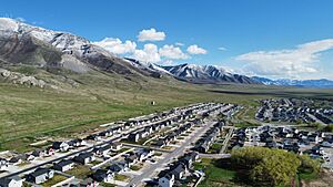
Lake Point is a city located in Tooele County, Utah, in the western United States. It sits on the south shore of the Great Salt Lake. The city is about 17 miles southwest of Salt Lake City International Airport. It is also 11 miles north of Tooele, Utah. Major roads like Interstate 80 and Utah State Route 36 serve the area.
The community was first settled in 1854. It was called E.T. City to honor Ezra T. Benson. In 1923, its name was changed to Lake Point. In 2021, the people of Lake Point voted to become an official city. They chose to have a five-member council to lead their new city.
Contents
Exploring Lake Point's History
Early Explorers and Pioneers
In the 1840s, the U.S. government sent explorers to map the western territories. One important explorer was John C. Frémont. He was a second lieutenant in the U.S. Army. In 1843, Frémont explored the Great Salt Lake in an inflatable boat. He created a detailed map of the lake and its surroundings.
Frémont's maps helped other explorers. One of them was Lansford Hastings. Hastings wrote a popular book in 1845 called "The Emigrants' Guide to Oregon and California." This book suggested a shortcut to California called the Hastings Cutoff. This route went south of the Great Salt Lake. Many settlers tried this new path, but it was very difficult.
The Donner Party was a group of pioneers who used the Hastings Cutoff in 1846. They faced many challenges and were slowed down. They met Lansford Hastings near a landmark called Black Rock. The Donner Party members later said they were the ones who named Black Rock.
In August 1846, the Donner Party camped near a spring in what is now Lake Point. Today, you can find a historical marker about their journey at Emigration Park. Their difficult trip through the Hastings Cutoff became a warning to future travelers.
Brigham Young, a leader of the Church of Jesus Christ of Latter-day Saints, studied Frémont's maps. These maps helped him choose the route for the first Mormon pioneers. In 1847, Brigham Young and other men explored the Hastings Cutoff. They looked for water, good soil, and other natural resources in the Tooele Valley. They saw that the valley had potential for raising animals.
Later, in 1849, Captain Howard Stansbury of the U.S. Army also explored the Great Salt Lake area. His team built an adobe structure in the Tooele Valley. This building was one of the first known structures in the valley. It was near a large rock tower, which became known as Adobe Rock.
The Founding of E.T. City
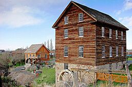
Mormon pioneers first visited the Lake Point area on July 27, 1847. However, the Tooele Valley was not formally settled until 1849. That year, Apostle Ezra T. Benson hired men to build mills and care for his cattle. Cyrus and Juda Tolman, along with Phineas R. Wright, built sawmills and a grist mill. John Rowberry and Robert Skelton arrived later to winter Benson's cattle.
On April 24, 1850, Ezra T. Benson organized the first local church group. More Mormon settlers arrived that year, including Peter Maughan. In 1851, Tooele County was officially formed.
In 1853, a committee was chosen to find a location for a new settlement called E.T. City. They also planned to build a dam. In 1854, they spent money to build the dam, but it failed. They then spent more money to bring water from Twin Springs to the new settlement. Peter Maughan's house was moved to this new location in August 1854. Other settlers also built homes there.
In October 1854, Peter Maughan became the leader of E.T. City. The area named E.T. City stretched from the Benson Grist Mill to E.T. Hill (Adobe Rock) and all the way to Black Rock (Great Salt Lake). This was made official in 1855.
The first year of farming in E.T. City, 1855, was tough. A huge swarm of grasshoppers destroyed the crops. In 1856, the soil became salty when watered, ruining most of that year's harvest. Brigham Young allowed some settlers to leave E.T. City with Peter Maughan. They moved to Cache Valley and founded Maughan's Fort, which became Wellsville, Utah.
| Historical population | |||
|---|---|---|---|
| Census | Pop. | %± | |
| 1860 | 141 | — | |
| 1870 | 114 | −19.1% | |
| 1880 | 177 | 55.3% | |
| 1890 | 206 | 16.4% | |
| 1900 | 192 | −6.8% | |
| 1910 | 179 | −6.8% | |
| 1920 | 196 | 9.5% | |
| 1930 | 299 | 52.6% | |
| 1940 | 231 | −22.7% | |
| 1950 | 190 | −17.7% | |
| Source: U.S. Census Bureau | |||
In 1857, the first meetinghouse for the local church group was built. It was a small log building. By 1868, the population was 97 people. An irrigation company was formed to bring water to farms. Mail service also began between E.T. City and Richville.
A new church meetinghouse made of rock was finished in 1884. This building also served as an elementary school until 1894. A separate schoolhouse was then built. In 1985, a modern brick building replaced the old rock church.
Tourism and Railways
Bathing in the Great Salt Lake became a popular activity for fun. In 1860, Heber C. Kimball, a church leader, built a rock ranch house near Black Rock. This house had bath houses and was used for entertaining guests. It was one of the first tourist attractions along the Great Salt Lake.
After Heber C. Kimball passed away, his son Heber P. Kimball, John Willard Young (Brigham Young's son), and Dr. Jeter Clinton invested in resorts and transportation in the Lake Point area.
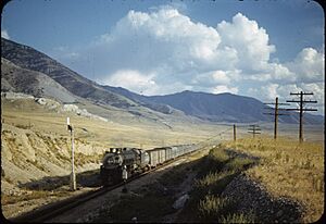
In 1869, John W. Young helped build the Utah Central Railroad. This railroad connected Salt Lake City to the first transcontinental railroad. One of its stops was called Lake Side, where the Lake Side resort opened in 1870.
In 1871, Jeter Clinton built the Lake House at Clinton's Landing in Lake Point. From the Lake Side resort, people could pay to ride the "City of Corinne" steamboat to Lake Point. By 1875, John W. Young became president of the new Utah Western Railway. This railway connected Salt Lake City to a train stop called Lake Point. Next to this station was Clinton's new three-story Lake Point Hotel. It had bath houses and a dock for the steamboat.
In 1877, famous naturalist John Muir visited. He wrote that Lake Point was a wonderful place for visitors. He described the clear water, wildflowers, and beautiful mountains. Many special trains brought people to bathe, dance, and explore the hills.
The success of the Lake Point resort and train stop made the community famous. Even though the town was called E.T. City in early records, "Lake Point" became the common name on maps, post offices, and train stops.
Running railroads and resorts was challenging. The Utah Western Railway faced financial problems and was sold in 1880. Resorts on the Great Salt Lake also struggled with changing lake levels. Sometimes the water was too far from the resort buildings.
In 1892, the Clinton property was sold to the Buffalo Park Land Company. They planned a huge resort, mapping streets and planting trees. They even brought in buffalo! However, their plans did not work out. The remaining buffalo became the start of the buffalo herd on nearby Antelope Island.
Geography and Climate
Lake Point is located near the Oquirrh Mountains. These mountains look calm and beautiful, with snow-capped peaks. The lower parts of the mountains have purple colors from small oak trees. Higher up, you can see faint green from grasses and dark pine forests.
Looking southward from the south end of Salt Lake, the two northmost peaks of the Oquirrh Range are seen swelling calmly into the cool sky without any marked character, excepting only their snow crowns, and a few weedy-looking patches of spruce and fir, the simplicity of their slopes preventing their real loftiness from being appreciated. Gray, sagey plains circle around their bases, and up to a height of a thousand feet or more their sides are tinged with purple, which I afterwards found is produced by a close growth of dwarf oak just coming into leaf. Higher you may detect faint tintings of green on a gray ground, from young grasses and sedges; then come the dark pine woods filling glacial hollows, and over all the smooth crown of snow.
Lake Point has a climate typical of the Great Salt Lake area. It experiences warm summers and cold winters. The weather can change quickly, especially with storms coming off the lake or from the mountains.
 | James Van Der Zee |
 | Alma Thomas |
 | Ellis Wilson |
 | Margaret Taylor-Burroughs |


