
Oquirrh Mountains facts for kids
Quick facts for kids Oquirrh Mountains |
|
|---|---|

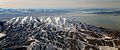
North end of the Oquirrh Mountains, view from the descent to the Salt Lake City airport
|
|
| Highest point | |
| Peak | Flat Top Mountain |
| Elevation | 10,613 ft (3,235 m) |
| Dimensions | |
| Length | 30 mi (48 km) N-S |
| Width | 15 mi (24 km) E-W |
| Geography | |

Oquirrh Mountains
Location in Utah
|
|
| Country | United States |
| Parent range | Great Basin |
The Oquirrh Mountains are a mountain range in Utah, USA. They stretch about 30 miles (50 km) from north to south. These mountains form the western edge of Salt Lake Valley, separating it from Tooele Valley. The range reaches from northwestern Utah County to the southern shore of the Great Salt Lake.
The highest point in the Oquirrh Mountains is Flat Top Mountain (Utah), which stands tall at 10,620 feet (3,237 meters). The name "Oquirrh" comes from the Goshute language and means "wood sitting."
Contents
Mining in the Oquirrh Mountains
The Oquirrh Mountains are famous for their rich mineral deposits. People have mined here for gold, silver, and lead. Most notably, the mountains are home to the Bingham Canyon Mine. This is one of the world's largest open pit mines, known for its huge copper deposits.
When you look at the mountains from Salt Lake City, you can see a lot of rock material that has been dug out from the Kennecott mine. This material is called "overburden." At the northern end of the range, there is a large complex where ore from the mine is refined into useful metals. Dark waste materials from this refining process can be seen from the nearby I-80 freeway. It is believed that the value of minerals found here is greater than the combined value of gold and silver from the famous California, Nevada, and Klondike gold rushes.
Wildlife and Nature
In the colder winter months, the Oquirrh Mountains become a temporary home for bald eagles. These majestic birds can often be spotted on the cliffs on the western side of the range, especially near the reservoir close to the town of Stockton.
The mountains also feature many deep canyons and thick forests. These forests are mostly made up of conifer trees and aspen trees. The area is a lively habitat for many animals, including butterflies, deer, mountain lions, and squirrels.
Popular Canyons
Two well-known canyons in the Oquirrh Mountains are Yellow Fork Canyon and Butterfield Canyon. Yellow Fork Canyon has a popular trail managed by Salt Lake County. It is also home to several neighborhoods with controlled access.
Butterfield Canyon has a paved road that connects Tooele with Herriman. A small part of the road on the Tooele side is dirt, but it is kept in good condition. This road climbs to a high point of 9,180 feet (2,798 meters) above sea level. At night, the entrance to Butterfield Canyon can be dangerous because large groups of deer often move into the nearby farmlands to find food.

Farnsworth Peak: A Communication Hub
The northern part of the Oquirrh Mountain range has a peak called Farnsworth Peak. This peak is very important for communication in the Salt Lake City area. It hosts almost all the FM radio and TV station transmitters for the city.
Farnsworth Peak is also used for important emergency communications. This includes signals for police, firefighters, and EMS (Emergency Medical Services). Many local businesses and amateur radio operators also have their transmitters located on Farnsworth Peak.

Images for kids
-
Aerial view of north end of Oquirrh Mountains
See also
 In Spanish: Montañas Oquirrh para niños
