
Stansbury Mountains facts for kids
Quick facts for kids Stansbury Mountains |
|
|---|---|

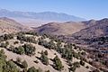
View south-southeast, from Timpie area
|
|
| Highest point | |
| Peak | Deseret Peak |
| Elevation | 11,035 ft (3,363 m) |
| Dimensions | |
| Length | 28 mi (45 km) N-S |
| Geography | |

Location in Utah
|
|
| Country | United States |
| Communities | Timpie, Flux, Burmester, Grantsville, Iosepa, Rush Valley, Saint John and Clover |
| Range coordinates | 40°31′02″N 112°38′01″W / 40.5171636°N 112.6335728°W |
The Stansbury Mountains are a mountain range in Utah, United States. They are about 28 miles (45 km) long. These mountains are located in eastern Tooele County.
The mountains are named after U.S. Army Major Howard Stansbury. He was a special engineer who explored and mapped the area. The Stansbury Mountains stretch from north to south. They begin near the Great Salt Lake and extend into the Great Salt Lake Desert.
On the west side of the mountains is Skull Valley. The southern part of the range is home to the Deseret Peak Wilderness. A large part of the mountains is also within the Uinta-Wasatch-Cache National Forest.
Contents
About the Stansbury Mountains
The Stansbury Mountains are mostly one big mountain mass. They have a continuous ridgeline that runs from north to south. These mountains are connected to the Onaqui Mountains at their southern end.
The widest part of the range is in the south, about 10 miles (16 km) across. It gets narrower towards the Great Salt Lake, becoming about 6 miles (10 km) wide. The very northern tip narrows even more near Timpie. Close to the lake, you can find the Timpie Springs Waterfowl Management Area. This is a special place for birds.
Deseret Peak: The Highest Point
The highest point in the Stansbury Mountains is Deseret Peak. This peak stands tall at 11,035 feet (3,363 meters). It is located within the Deseret Peak Wilderness.
Nearby Valleys and Towns
Skull Valley is on the west side of the mountains. The Skull Valley Indian Reservation is located at the base of the southwestern foothills.
On the east side of the Stansbury Mountains is Tooele Valley. Here, you can find several communities. These include Burmester, Grantsville, and Rush Valley.
Getting to the Mountains
Utah State Route 196 is a road that goes through Skull Valley. It connects places like Dugway, Iosepa, and Timpie. Most roads on the west side of the mountains are unpaved.
The east side of the mountains has more towns and roads. Utah State Route 138 travels from Interstate 80 to Grantsville. Interstate 80 runs along the northern edge of the Stansbury Mountains. It connects towns like Delle and Burmester.
Images for kids
-
Southeast view of the west Stansburys, looking over Skull Valley from Cedar Mountain Wilderness.
-
View looking east-southeast of the northwest region near Delle, showing the northeast foothills of the Cedar Mountains.


