Elko County, Nevada facts for kids
Quick facts for kids
Elko County
|
||
|---|---|---|
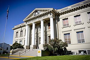
Elko County Courthouse in Elko
|
||
|
||
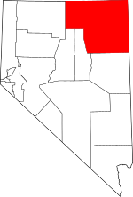
Location within the U.S. state of Nevada
|
||
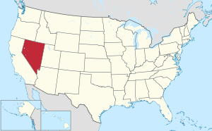 Nevada's location within the U.S. |
||
| Country | ||
| State | ||
| Founded | 1869 | |
| Named for | Elko | |
| Seat | Elko | |
| Largest city | Elko | |
| Area | ||
| • Total | 17,203 sq mi (44,560 km2) | |
| • Land | 17,170 sq mi (44,500 km2) | |
| • Water | 33 sq mi (90 km2) 0.2% | |
| Population
(2020)
|
||
| • Total | 53,702 | |
| • Estimate
(2023)
|
54,293 |
|
| • Density | 3.12166/sq mi (1.20528/km2) | |
| Time zones | ||
| Majority of county | UTC−8 (Pacific) | |
| • Summer (DST) | UTC−7 (PDT) | |
| West Wendover | UTC−7 (Mountain) | |
| • Summer (DST) | UTC−6 (MDT) | |
| Congressional district | 2nd | |
Elko County is a large area in the northeastern part of Nevada, United States. It's like a big neighborhood with its own government. In 2020, about 53,702 people lived here. The main town and government center is Elko.
Elko County was created on March 5, 1869. It was formed from a part of Lander County. It is one of the biggest counties in the United States. Only a few other counties are larger. Elko County is also home to a big part of the Duck Valley Indian Reservation. This land belongs to the Shoshone-Paiute people, a federally recognized tribe.
Contents
History of Elko County
This area has been home to Native American tribes for a very long time. These include the Western Shoshone, Northern Paiute, and Bannock peoples. They lived here for centuries, following their traditional ways.
Elko County was officially created in 1869. Its name comes from the town of Elko, which is its main city.
In 1877, the Duck Valley Indian Reservation was set up. This was done by a special order from the President for the Western Shoshone tribe. Later, in 1886, the reservation was made even bigger. This was to include the Paiute people. Today, these two tribes work together. They farm and raise animals on their land.
The number of people living in Elko County grew a lot in the late 1900s. More jobs became available, and the area became more popular.
Geography and Nature
Elko County is very large. It covers about 17,203 square miles. Most of this area is land, with only a small part being water. It is the fourth-largest county in the United States by land area. It's bigger than many states!
The land in Elko County changes a lot. The lowest parts are around 4,300 feet high. These areas are near the salt flats of the Great Salt Lake Desert. The highest point is Ruby Dome, which is 11,387 feet tall. This mountain is part of the Ruby Mountains. Another important mountain is Pilot Peak.
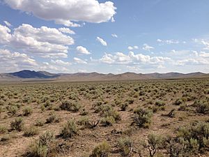
The county has different types of land. Most of it is part of the Great Basin section. This is a dry area with mountains and valleys. There are also parts that are like the Snake River Plain. This is a flatter area.
Protected Natural Areas
Some parts of Elko County are protected. These areas help keep nature safe.
- Humboldt-Toiyabe National Forest (a part of this forest is in the county)
- Ruby Lake National Wildlife Refuge (a part of this refuge is in the county)
Neighboring Counties
Elko County shares borders with many other counties:
- Owyhee County, Idaho - to the northwest
- Twin Falls County, Idaho - to the north
- Cassia County, Idaho - to the northeast
- Box Elder County, Utah - to the east
- Tooele County, Utah - to the southeast
- White Pine County - to the south
- Eureka County - to the southwest
- Lander County - to the southwest
- Humboldt County - to the west
Time Zones in Elko County
Most of Elko County is in the Pacific Time Zone. This is the same time zone as California. However, the city of West Wendover is in the Mountain Time Zone. This is because it is very close to Utah. Some other towns also use Mountain Time unofficially. This helps them work with nearby towns in Idaho.
People of Elko County
| Historical population | |||
|---|---|---|---|
| Census | Pop. | %± | |
| 1870 | 3,447 | — | |
| 1880 | 5,716 | 65.8% | |
| 1890 | 4,794 | −16.1% | |
| 1900 | 5,688 | 18.6% | |
| 1910 | 8,133 | 43.0% | |
| 1920 | 8,083 | −0.6% | |
| 1930 | 9,960 | 23.2% | |
| 1940 | 10,912 | 9.6% | |
| 1950 | 11,654 | 6.8% | |
| 1960 | 12,011 | 3.1% | |
| 1970 | 13,958 | 16.2% | |
| 1980 | 17,269 | 23.7% | |
| 1990 | 33,530 | 94.2% | |
| 2000 | 45,291 | 35.1% | |
| 2010 | 48,818 | 7.8% | |
| 2020 | 53,702 | 10.0% | |
| 2023 (est.) | 54,293 | 11.2% | |
| U.S. Decennial Census 1790-1960 1900-1990 1990-2000 2010-2018 |
|||
In 2010, there were 48,818 people living in Elko County. There were 17,442 households, which are groups of people living together. About 39.8% of these households had children under 18. The average age of people in the county was 33.4 years old.
The average income for a family in the county was about $75,171 per year. This means many families earn a good living here.
Getting Around Elko County
You can travel through Elko County in several ways. Many highways cross the county. Some of these are very important national roads. The county also has its own local roads. However, many of these are dirt roads and are not cleared in winter.
If you want to fly, there is the Elko Regional Airport in Elko. You can fly from here to Salt Lake City. Other smaller airports are in Jackpot, Owyhee, and Wells.
You can also travel by train. Amtrak has a train station in Elko. The train is called the California Zephyr. It travels once a day, either east or west.
Main Roads and Highways
Here are some of the major roads that go through Elko County:
 Interstate 80
 Interstate 80 Business (Carlin)
 Interstate 80 Business (Elko)
 Interstate 80 Business (Wells)
 Interstate 80 Business (West Wendover, Nevada–Wendover, Utah)
 U.S. Route 93
 U.S. Route 93 Alternate
 State Route 221
 State Route 223
 State Route 225
 State Route 226
 State Route 227
 State Route 228
 State Route 229
 State Route 230
 State Route 231
 State Route 232
 State Route 233
 State Route 278
 State Route 535
 State Route 766
 State Route 767
Towns and Communities
Elko County has several towns and smaller communities.
Cities
- Carlin
- Elko (This is the county seat, where the main government offices are)
- Wells
- West Wendover
Census-designated places
These are areas that are like towns but don't have their own city government.
Unincorporated communities
These are smaller settlements that are not officially part of a city or census-designated place.
- Contact
- Currie
- Deeth
- Halleck
- Jack Creek
- Jarbidge
- Jiggs
- Lee
- Midas
- North Fork
- Pleasant Valley
- Ryndon
- Shantytown
- South Fork
- Tuscarora
- Twin Bridges
- Welcome
- Wild Horse
Ghost towns
These are towns that used to be active but are now mostly empty or abandoned.
- Arthur
- Bullion
- Cobre
- Dinner Station
- Hunter
- Huntington
- Metropolis
- Patsville
- Pequop
- San Jacinto
- Shafter
Education
Children in Elko County go to schools run by the Elko County School District.
See also
 In Spanish: Condado de Elko para niños
 | Lonnie Johnson |
 | Granville Woods |
 | Lewis Howard Latimer |
 | James West |


