Cassia County, Idaho facts for kids
Quick facts for kids
Cassia County
|
||
|---|---|---|

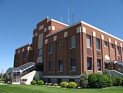
Cassia County Courthouse
|
||
|
||

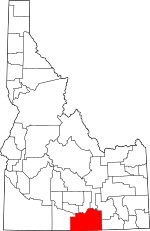
Location within the U.S. state of Idaho
|
||
 Idaho's location within the U.S. |
||
| Country | ||
| State | ||
| Founded | February 20, 1879 | |
| Named for | Cassia Creek | |
| Seat | Burley | |
| Largest city | Burley | |
| Area | ||
| • Total | 2,580 sq mi (6,700 km2) | |
| • Land | 2,565 sq mi (6,640 km2) | |
| • Water | 15 sq mi (40 km2) 0.6% | |
| Population
(2020)
|
||
| • Total | 24,655 |
|
| • Density | 9.6/sq mi (3.7/km2) | |
| Time zone | UTC−7 (Mountain) | |
| • Summer (DST) | UTC−6 (MDT) | |
| Congressional district | 2nd | |
Cassia County is a county located in the state of Idaho, USA. In 2020, about 24,655 people lived there. The main city and county seat is Burley. Cassia County is part of the Burley, ID area, which is a group of towns connected by jobs and daily life.
Contents
History of Cassia County
The first Europeans came to the Milner area in Cassia County in 1811. Fur trappers helped create the Oregon Trail. This famous trail ran along the county's northern border. The Raft River area was a key spot. It was where the Oregon Trail split off to become the California Trail.
Hundreds of thousands of people traveled through Cassia County on these trails. Some of these travelers decided to settle down here. A stagecoach line was set up in 1869. It connected Kelton, Utah, to Boise, Idaho. There were stagecoach stops along the way, including one at the City of Rocks. Other stops were about 10-12 miles apart. One such stop was at Oakley Meadows.
William Oakley settled at Oakley Meadows in 1870. Ranching also started to grow in 1872. People began settling in nearby Albion in 1873. Many Mormon settlers arrived in 1875. By 1880, Albion had 257 residents. Mormon settlement in Oakley began on June 1, 1878. Four Mormon men each claimed 160 acres to start their community.
The settlements mainly focused on farming. By 1885, there were over 38,000 cattle in the area. Malta was settled before 1890. The Malta area had 172 residents by the 1890 census.
The Albion State Normal School was built in Albion in 1893. This school trained teachers for Idaho. Its programs moved to Idaho State College in 1951. Today, that college is Idaho State University.
Burley was planned and settled in 1905. This happened after a train line was built through the town. Declo was settled by 1909. It was first known as Marshfield.
Cassia County was officially created on February 20, 1879. It was formed from Owyhee County. Albion was the first county seat. A western part of Cassia County became Twin Falls County in 1907. The county got its current shape when an eastern part became Power County in 1913. The county seat moved to Burley in 1918. The county was named after Cassia Creek. The creek might have been named for John Cazier, an early settler, or for a plant found there.
Geography and Nature
Cassia County covers about 2,580 square miles. Most of this (2,565 square miles) is land. Only about 15 square miles (0.6%) is water. The highest point in the county is Cache Peak. It is 10,339 feet (3,151 meters) above sea level. This peak is in the Albion Mountains. The lowest point is Milner Lake. This lake is a reservoir on the Snake River. It is 4,134 feet (1,260 meters) above sea level.
The northern part of the county is called the Magic Valley. This area is part of the Snake River Plain. Many mountain ranges stretch north from the southern border. They get smaller as they get closer to the Snake River. The river flows from east to west.
The Silent City of Rocks National Reserve is in the southern part of the county. This special place has huge granite rocks. Some of these rocks are 2.5 billion years old!
Neighboring Counties
- Minidoka County - north
- Blaine County - north
- Power County - northeast
- Oneida County - east
- Box Elder County, Utah - southeast
- Elko County, Nevada - southwest
- Twin Falls County - west
- Jerome County - northwest
Major Roads
 Interstate 84
 Interstate 86
 US 30
US 30 SH-27
SH-27 SH-77
SH-77 SH-81
SH-81
Protected Natural Areas
- City of Rocks National Reserve
- Minidoka National Wildlife Refuge (part)
- Sawtooth National Forest (part)
Population Information
| Historical population | |||
|---|---|---|---|
| Census | Pop. | %± | |
| 1880 | 1,312 | — | |
| 1890 | 3,143 | 139.6% | |
| 1900 | 3,951 | 25.7% | |
| 1910 | 7,197 | 82.2% | |
| 1920 | 15,659 | 117.6% | |
| 1930 | 13,116 | −16.2% | |
| 1940 | 14,430 | 10.0% | |
| 1950 | 14,629 | 1.4% | |
| 1960 | 16,121 | 10.2% | |
| 1970 | 17,017 | 5.6% | |
| 1980 | 19,427 | 14.2% | |
| 1990 | 19,532 | 0.5% | |
| 2000 | 21,416 | 9.6% | |
| 2010 | 22,952 | 7.2% | |
| 2020 | 24,655 | 7.4% | |
| 2023 (est.) | 25,696 | 12.0% | |
| U.S. Decennial Census 1790–1960, 1900–1990, 1990–2000, 2010–2020 2020 |
|||
In 2010, there were 22,952 people living in Cassia County. These people lived in 7,666 households. About 60.8% of households were married couples. The average household had almost 3 people. The average age of people in the county was 32 years old.
Schools and Education
Most of Cassia County is served by one main school district. It is called Cassia Joint School District #151. This district was formed in the 1950s. Other parts of the county are in different school districts. These include American Falls, Minidoka County, and Murtaugh.
The county is also near the College of Southern Idaho. This college is a place where students can go after high school.
High Schools in Cassia County
- Burley High School in Burley
- Cassia Alternative High School in Burley
- Declo High School in Declo
- Oakley High School in Oakley
- Raft River High School in Malta
Junior High Schools in Cassia County
- Burley Jr. High School in Burley
- Declo Jr. High School in Declo
- Oakley Jr. High School in Oakley
- Raft River Jr. High School in Malta
Elementary Schools in Cassia County
- Albion Elementary School in Albion
- Almo Elementary School in Almo
- Declo Elementary in Declo
- Dworshak Elementary School in Burley
- Evans Elementary School in Burley
- Mountain View Elementary School in Burley
- Raft River Elementary School in Malta
- White Pine Elementary School in Burley
Towns and Communities
Cities in Cassia County
Smaller Communities
- Almo
- Artesian City
- Basin
- Beetville
- Bridge
- Connor
- Elba
- Golden Valley
- Hobson
- Idahome
- Jackson (also in Minidoka County)
- Kenyon
- Marion
- Milner Dam (also in Jerome and Twin Falls Counties)
- Pella
- Ruby
- Springdale
- Sublett
- Trout
- Unity
- View
See also
 In Spanish: Condado de Cassia (Idaho) para niños
 | Janet Taylor Pickett |
 | Synthia Saint James |
 | Howardena Pindell |
 | Faith Ringgold |


