Oneida County, Idaho facts for kids
Quick facts for kids
Oneida County
|
||
|---|---|---|

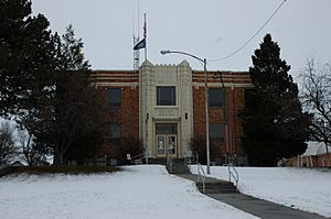
Oneida County Courthouse in Malad City
|
||
|
||

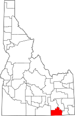
Location within the U.S. state of Idaho
|
||
 Idaho's location within the U.S. |
||
| Country | ||
| State | ||
| Founded | January 22, 1864 | |
| Named for | Oneida Lake, New York | |
| Seat | Malad City | |
| Largest city | Malad City | |
| Area | ||
| • Total | 1,202 sq mi (3,110 km2) | |
| • Land | 1,200 sq mi (3,000 km2) | |
| • Water | 1.5 sq mi (4 km2) 0.1% | |
| Population
(2020)
|
||
| • Total | 4,564 |
|
| • Density | 3.8/sq mi (1.5/km2) | |
| Time zone | UTC−7 (Mountain) | |
| • Summer (DST) | UTC−6 (MDT) | |
| Congressional district | 2nd | |
Oneida County is a county in Idaho, a state in the United States. In 2020, about 4,564 people lived here. The main town and biggest city is Malad City. Most people in the county live in Malad City and the area around it called Malad Valley.
Contents
History of Oneida County
Oneida County got its name from Oneida Lake in New York. This is because many of the first people who settled here came from that area.
The county was officially started on January 22, 1864. Its first main town, called the county seat, was Soda Springs. This area is now part of Caribou County.
Later, in 1866, the county seat moved to Malad City. This happened because Malad City was growing. It was also on an important road for moving goods and a stagecoach line. This road connected Corinne, Utah, to the mines in Butte, Montana.
When it was first formed, Oneida County was very large. It was one of the biggest counties in Idaho in terms of both land and people. Over time, its size changed many times. Parts of it were given to other territories or used to create new counties. For example, it lost land when Montana Territory and Wyoming Territory were created. New counties like Bear Lake County and Cassia County were also formed from its land.
Even with these changes, the number of people living in Oneida County grew. Many Mormons moved to Idaho's southern border, which helped the population increase. In 1880, Oneida County became the most populated county in Idaho.
However, when Bingham County was created, Oneida County lost many people. Later, in 1913, the creation of Franklin and Power Counties also caused the population to drop. After 1920, the number of people in Oneida County kept going down for about 50 years. Since then, the population has slowly started to grow again.
Geography of Oneida County
Oneida County covers about 1,202 square miles (3,113 square kilometers). Most of this area, about 1,200 square miles (3,108 square kilometers), is land. Only a small part, about 1.5 square miles (3.9 square kilometers), is water.
The highest point in the county is Oxford Peak. It stands about 9,285 feet (2,830 meters) above sea level. The land here has many valleys and mountains or hills. Most areas are covered with grasslands and sagebrush plants. Part of the Curlew National Grassland is also located within the county.
Neighboring Counties
- Power County – to the north
- Bannock County – to the northeast
- Franklin County – to the east
- Cache County, Utah – to the southeast
- Box Elder County, Utah – to the south
- Cassia County – to the west
Main Roads
Protected Natural Areas
- Caribou National Forest (part)
- Curlew National Grassland (part)
- Sawtooth National Forest (part)
Population of Oneida County
| Historical population | |||
|---|---|---|---|
| Census | Pop. | %± | |
| 1870 | 1,922 | — | |
| 1880 | 6,964 | 262.3% | |
| 1890 | 6,819 | −2.1% | |
| 1900 | 8,933 | 31.0% | |
| 1910 | 15,170 | 69.8% | |
| 1920 | 6,723 | −55.7% | |
| 1930 | 5,870 | −12.7% | |
| 1940 | 5,417 | −7.7% | |
| 1950 | 4,387 | −19.0% | |
| 1960 | 3,603 | −17.9% | |
| 1970 | 2,864 | −20.5% | |
| 1980 | 3,258 | 13.8% | |
| 1990 | 3,492 | 7.2% | |
| 2000 | 4,125 | 18.1% | |
| 2010 | 4,286 | 3.9% | |
| 2020 | 4,564 | 6.5% | |
| 2023 (est.) | 4,953 | 15.6% | |
| U.S. Decennial Census 1790–1960 1900–1990 1990–2000 2010, 2020 |
|||
2010 Census Information
In 2010, there were 4,286 people living in Oneida County. These people lived in 1,545 homes, and 1,161 of these were families. The county had about 3.6 people per square mile.
Most of the people in the county were white (96.7%). Smaller groups included Asian, American Indian, and Black or African American people. About 2.9% of the population were of Hispanic or Latino background.
Many families in the county were married couples living together (65.9%). About 36.4% of homes had children under 18 living there. The average age of people in the county was about 39 years old.
Arts and Culture in Oneida County
Museums and Other Interesting Places
Oneida County has seven buildings that are listed on the National Register of Historic Places. This means they are important historical sites. They include:
- The Co-Op Block and J. N. Ireland Bank, in Malad City
- The D.L. Evans, Sr. Bungalow, in Malad City
- The Jedd Jones House, in Malad City
- The Malad Second Ward Tabernacle, in Malad City
- The Oneida County Courthouse, in Malad City
- The Samaria Historic District, in Samaria
- The United Presbyterian Church, in Malad City
Notable People from Oneida County
- John V. Evans (1925–2014): He was the Governor of Idaho from 1977 to 1987. He was born in Malad City.
- William Marion Jardine (1879–1955): He served as the U.S. Secretary of Agriculture from 1925 to 1929. He was also the U.S. Ambassador to Egypt. He was born in Oneida County.
Communities in Oneida County
City
Small Towns and Areas
- Cherry Creek
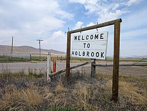
- Holbrook
- Pleasantview
- Samaria
- Stone
- Woodruff
Education in Oneida County
Most of Oneida County is part of the Oneida County School District 351. A small part of the county is in the Cassia County Joint School District 151.
See also
 In Spanish: Condado de Oneida (Idaho) para niños
 | Sharif Bey |
 | Hale Woodruff |
 | Richmond Barthé |
 | Purvis Young |


