
Samaria, Idaho facts for kids
Quick facts for kids
Samaria, Idaho
|
|
|---|---|

Samaria, Idaho
Location in Idaho

Samaria, Idaho
Location in the United States
|
|
| Country | United States |
| State | Idaho |
| County | Oneida |
| Elevation | 4,478 ft (1,365 m) |
| Time zone | UTC-7 (Mountain (MST)) |
| • Summer (DST) | UTC-6 (MDT) |
| Area code(s) | 208, 986 |
| GNIS feature ID | 398088 |
|
Samaria Historic District
|
|
| Lua error in Module:Location_map at line 420: attempt to index field 'wikibase' (a nil value). | |
| Location | Roughly bounded by Main and 3rd Sts., 1st Ave., N. and south end of 2nd St., Samaria, Idaho |
|---|---|
| Area | 153 acres (62 ha) |
| NRHP reference No. | 79003740 |
| Added to NRHP | June 11, 1979 |

Samaria is a small, unincorporated community located in Oneida County, Idaho, in the United States. An "unincorporated community" means it's a place where people live together, but it doesn't have its own local government like a city or town. It's about 7 miles (11 km) southwest of Malad City.
Samaria is especially known for its Samaria Historic District. This special area is recognized for its historical importance and is listed on the National Register of Historic Places. This means the buildings and the layout of the district are protected because they show what life was like in the past.
Contents
What is the Samaria Historic District?
The Samaria Historic District covers about 153 acres (62 hectares). It was added to the National Register of Historic Places on June 11, 1979. This district includes 36 buildings that are considered "contributing buildings." This means they help tell the story of the area's history.
Where is the Historic District Located?
The historic district is generally found around Main and 3rd Streets, and 1st Avenue North, extending to the south end of 2nd Street in Samaria. If you visit, you can walk around and see many of these old buildings.
A Look Back at Samaria's History
Samaria was originally settled as a Mormon town. Many early settlers in this part of Idaho were members of The Church of Jesus Christ of Latter-day Saints, often called Mormons. They built their homes and community here, creating a unique historical landscape.
Over the years, some changes have happened in the district. For example, after an earthquake in 1975, some of the older buildings in the district had to be taken down. Despite these changes, the district still holds many important historical structures.
Images for kids
-
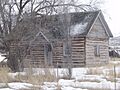
A historic log cabin in Samaria, showing traditional building styles.
