Oneida Lake facts for kids
Quick facts for kids Oneida Lake |
|
|---|---|

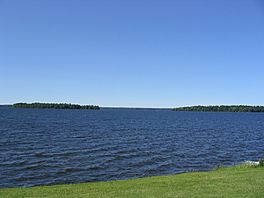
View of Frenchman Island and Dunham Island from Cicero, a suburban Syracuse town
|
|
| Location | Oneida / Oswego counties, New York, United States |
| Coordinates | 43°12′0″N 75°54′0″W / 43.20000°N 75.90000°W |
| Primary inflows | Oneida Creek, Fish Creek, Chittenango Creek |
| Primary outflows | Oneida River |
| Basin countries | United States |
| Max. length | 21 mi (34 km) |
| Max. width | 5 mi (8.0 km) |
| Surface area | 50,894 acres (79.5 sq mi) |
| Average depth | 22 ft (6.7 m) |
| Max. depth | 55 ft (17 m) |
| Water volume | .331 cu mi (1.38 km3) |
| Surface elevation | 369 ft (112 m) |
| Islands | Big Isle, Dunham's Island, Frenchman Island, Little Island, Long Island, Wantry Island |
| Settlements | (see article) |
Oneida Lake is the biggest lake completely inside New York state. It covers an area of about 79.8 square miles (207 km2).
This large lake is located northeast of Syracuse. It is also quite close to the Great Lakes. Water from Oneida Lake flows into the Oneida River. This river then joins the Oswego River, which eventually empties into Lake Ontario.
Oneida Lake is about 21 miles (34 km) long and 5 miles (8.0 km) wide. Its average depth is 22 feet (6.7 m). The shoreline stretches for about 55 miles (89 km). Many towns and parts of six counties are located in the area that drains into the lake. Oneida Creek flows into the lake's southeast part.
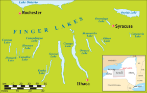
Even though it's not one of the famous Finger Lakes, Oneida Lake is sometimes called their "thumb." Because it is not very deep, the lake gets warmer than the deeper Finger Lakes in summer. In winter, its surface freezes solid. This makes it a popular spot for fun winter activities like ice fishing and snowmobiling.
Contents
What's in a Name?

Oneida Lake gets its name from the Oneida people. They are a Native American tribe from the Iroquois group. The Oneida people historically lived in the large area around the lake. They were one of the Six Nations of the Iroquois. In their language, the Oneida called the lake Tsioqui, which means "White Water."
Travel and Trade on the Lake
For a long time, Oneida Lake was a very important waterway. Before the Erie Canal opened in 1825, it helped connect the Atlantic Ocean to the middle of North America. People would travel up the Hudson River and Mohawk River. Then, they would carry their boats and goods over a short distance called the Oneida Carry. From there, they could use Wood Creek to reach Oneida Lake.
After crossing Oneida Lake, travelers would use the Oneida River. This river led to the Oswego River and then to Lake Ontario. From Lake Ontario, they could reach the other Great Lakes. This route was vital for trade and travel.
After the American Revolutionary War, the United States gained control of the land. White settlers improved the natural waterway. They built a canal with locks in Wood Creek. This made it easier for boats to reach Oneida Lake. From 1792 to 1803, they also dug a canal across the Oneida Carry. This greatly increased shipping on Oneida Lake.
However, in 1825, the Erie Canal was finished. This new canal was a direct route through the Mohawk Valley. It bypassed the Oneida Lake system. This meant that towns around Oneida Lake lost their main water connection to the east.
In 1835, a new canal, the (old) Oneida Canal, was built. It connected Oneida Lake to the Erie Canal system. This canal was about 4.5 miles (7.2 km) long. It ran from Higginsville on the Erie Canal to Wood Creek. However, this canal was not built very well. It had wooden locks and was closed in 1863.
In the early 1900s, the Erie Canal was rebuilt. It became the New York State Barge Canal. Engineers used natural rivers and lakes where they could. The new barges had their own engines. This meant they could travel on open water and against currents. The canal no longer needed paths for animals to pull the boats.
The new canal system entered Oneida Lake at Sylvan Beach. It left the lake at Brewerton, using the Oneida River. New walls were built at Sylvan Beach, Cleveland, and Brewerton. These walls allowed barges to load and unload goods. They also provided safe places for boats to stay overnight. A new break wall was also added. This wall stopped lake waves from entering the canal. These improvements gave towns around Oneida Lake access to waterways again. They could now travel east and west.
How Oneida Lake Was Formed

Oneida Lake is what's left of a huge ancient lake. This lake was called Glacial Lake Iroquois. It formed a very long time ago when giant glaciers blocked the flow of the St. Lawrence River. The St. Lawrence River is the outlet for the Great Lakes to the Atlantic Ocean. When the glaciers melted, much of the water drained away, leaving behind lakes like Oneida Lake.
Places Near Oneida Lake
Counties Around the Lake
Towns and Villages Near the Lake
- Brewerton (Southwest)
- Bridgeport (Southwest)
- Cicero (Southwest)
- Cleveland (North)
- Constantia (North)
- Hastings (West)
- Jewel (Northeast)
- Lakeport (South)
- Lenox (South)
- South Bay (Southeast)
- Sullivan (South)
- Sylvan Beach (East)
- Verona (East)
- Vienna (North)
- West Monroe (Northwest)
State Parks on the Lake
Oneida Lake in Space
Oneida Lake has a special namesake far away in space! There's a "lake" on Titan, one of Saturn's moons, called Oneida Lacus. This "lake" isn't made of water, but of liquid methane and ethane. It's located at 76.14°N and 131.83°W on Titan's surface.
 | May Edward Chinn |
 | Rebecca Cole |
 | Alexa Canady |
 | Dorothy Lavinia Brown |


