Madison County, New York facts for kids
Quick facts for kids
Madison County
|
|||
|---|---|---|---|

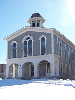
Old Madison County Courthouse
|
|||
|
|||

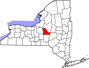
Location within the U.S. state of New York
|
|||
 New York's location within the U.S. |
|||
| Country | |||
| State | |||
| Founded | 1806 | ||
| Named for | James Madison | ||
| Seat | Wampsville | ||
| Largest city | Oneida | ||
| Area | |||
| • Total | 661 sq mi (1,710 km2) | ||
| • Land | 655 sq mi (1,700 km2) | ||
| • Water | 6.4 sq mi (17 km2) 1.0% | ||
| Population
(2020)
|
|||
| • Total | 68,016 |
||
| • Density | 100/sq mi (40/km2) | ||
| Time zone | UTC−5 (Eastern) | ||
| • Summer (DST) | UTC−4 (EDT) | ||
| Congressional district | 22nd | ||
Madison County is a county in the state of New York. In 2020, about 68,016 people lived here. Its main town, or county seat, is Wampsville.
The county is named after James Madison, who was the fourth President of the United States. Madison County was created in 1806. It is part of the Central New York area.
Madison County is also part of the larger Syracuse metropolitan area. It is home to special places like the International Boxing Hall of Fame and the National Abolition Hall of Fame and Museum.
Contents
History of Madison County
Early Peoples and Land
For thousands of years, Indigenous peoples lived around Oneida Lake. The Oneida Indian Nation are an Iroquoian-speaking group. They became a distinct culture in this area around the 1300s. The Oneida are one of the original Five Nations that formed the powerful Iroquois Confederacy, also known as the Haudenosaunee.
In 1683, English colonists started creating counties in New York. At that time, the area that is now Madison County was part of a huge county called Albany County. This large area included parts of New York, all of Vermont, and was thought to stretch all the way to the Pacific Ocean. However, Native American groups like the Oneida, Onondaga, and Mohawk mostly lived there.
Changes to County Borders
Over time, Albany County was divided into smaller counties. In 1772, a large western part became Tryon County. This county was named after William Tryon, who was the governor at the time.
After the American Revolutionary War, New York changed Tryon County's name to Montgomery County. This honored General Richard Montgomery, a hero of the war.
The Oneida Nation had helped the American Patriots during the war. Because of this, they were given land for a reservation near Oneida Lake. However, settlers wanted more land. In 1788, New York's Governor George Clinton bought some Oneida land. This was called the "Clinton Purchase" or the "Twenty Townships."
Land Disputes and Modern Times
Later, the United States Supreme Court said this sale was against the law. This is because New York State did not have the right to buy land directly from Native American tribes. Only the federal government could do that.
Over the years, Montgomery County was divided many times. Eventually, Chenango County was formed in 1798. Finally, in 1806, Madison County was created from parts of Chenango County.
In the late 1900s, the Oneida tribes from Wisconsin, New York, and Canada sued New York State. They wanted their ancestral lands back. The Supreme Court agreed that the original land sale was unconstitutional. In 2010, New York offered some land to the Oneida Tribe of Wisconsin to settle part of the lawsuit.
Geography of Madison County
Madison County covers about 661 square miles (1,712 square kilometers). Most of this is land, with about 6.4 square miles (16.6 square kilometers) being water.
The county is in central New York State. It is just east of Syracuse. The exact center of New York State is located in Pratts Hollow, which is in the Town of Eaton within Madison County.
Oneida Lake and Oneida Creek form part of the county's northern border. There used to be a large swamp south of the lake called the Great Swamp. It was drained in the early 1900s to create rich farmland. This area became known for growing onions. Chittenango Creek forms much of the western border.
Neighboring Counties
Madison County shares borders with several other counties:
- Chenango County is to the south.
- Onondaga County and Cortland County are to the west. Onondaga County has the longest border with Madison County.
- Otsego County is a small border in the southeast.
- Oneida County is to the northeast.
- Oswego County is across Oneida Lake to the north.
Population of Madison County
| Historical population | |||
|---|---|---|---|
| Census | Pop. | %± | |
| 1810 | 25,144 | — | |
| 1820 | 32,208 | 28.1% | |
| 1830 | 39,038 | 21.2% | |
| 1840 | 40,008 | 2.5% | |
| 1850 | 43,072 | 7.7% | |
| 1860 | 43,545 | 1.1% | |
| 1870 | 43,522 | −0.1% | |
| 1880 | 44,112 | 1.4% | |
| 1890 | 42,892 | −2.8% | |
| 1900 | 40,545 | −5.5% | |
| 1910 | 39,289 | −3.1% | |
| 1920 | 39,535 | 0.6% | |
| 1930 | 39,790 | 0.6% | |
| 1940 | 39,598 | −0.5% | |
| 1950 | 46,214 | 16.7% | |
| 1960 | 54,635 | 18.2% | |
| 1970 | 62,864 | 15.1% | |
| 1980 | 65,150 | 3.6% | |
| 1990 | 69,120 | 6.1% | |
| 2000 | 69,441 | 0.5% | |
| 2010 | 73,442 | 5.8% | |
| 2020 | 68,016 | −7.4% | |
| U.S. Decennial Census 1790–1960 1900–1990 1990–2000 2010–2013 |
|||
In 2000, there were 69,441 people living in Madison County. Most people were White (96.49%). Other groups included African American, Native American, and Asian people. About 1.06% of the population was Hispanic or Latino.
The median age in the county was 36 years old. This means half the people were younger than 36, and half were older.
2020 Census Information
| Race | Number | Percent |
|---|---|---|
| White (not Hispanic) | 60,965 | 89.63% |
| Black or African American (not Hispanic) | 1071 | 1.6% |
| Native American (not Hispanic) | 435 | 0.64% |
| Asian (not Hispanic) | 664 | 1.0% |
| Pacific Islander (not Hispanic) | 11 | 0.01% |
| Other/mixed (not Hispanic) | 3,197 | 4.7% |
| Hispanic or Latino | 1,673 | 2.5% |
Most of Madison County is rural, meaning it has a lot of open land and small towns. However, some areas near Syracuse, like Cazenovia, are more like suburbs.
Communities in Madison County
Largest Towns and Villages
| # | Location | Population | Type | Area |
|---|---|---|---|---|
| 1 | Oneida | 11,390 | City | Northeast |
| 2 | Chittenango | 5,081 | Village | Northwest |
| 3 | Canastota | 4,804 | Village | Northwest |
| 4 | Hamilton | 4,239 | Village | Southeast |
| 5 | Cazenovia | 2,835 | Village | Southwest |
| 6 | Morrisville | 2,199 | Village | Southeast |
| 7 | ‡Bridgeport | 1,490 | CDP | Northwest |
| 8 | ‡Earlville | 872 | Village | Southeast |
| 9 | DeRuyter | 558 | Village | Southwest |
| 10 | †Wampsville | 543 | Village | Northeast |
| 11 | Munnsville | 474 | Village | Northeast |
| 12 | Madison | 305 | Village | Southeast |
† - This is the county seat, where the main government offices are.
‡ - This community is not entirely within Madison County.
Towns in Madison County
The towns in the southern part of Madison County were once part of the "Twenty Townships" land deal with the Oneida tribe.
Small Villages (Hamlets)
- Hubbardsville
- Leonardsville
- New Woodstock
- Peterboro
- West Edmeston
Education in Madison County
School Districts
Many different school districts serve the students of Madison County:
- Brookfield Central School District
- Canastota Central School District
- Cazenovia Central School District
- Chittenango Central School District
- DeRuyter Central School District
- East Syracuse-Minoa Central School District
- Edmeston Central School District
- Fabius-Pompey Central School District
- Fayetteville-Manlius Central School District
- Georgetown-South Otselic Central School District
- Hamilton Central School District
- Madison Central School District
- Morrisville-Eaton Central School District
- Mount Markham Central School District
- Oneida City School District
- Sherburne-Earlville Central School District
- Sherrill City School District
- Stockbridge Valley Central School District
- Unadilla Valley Central School District
- Waterville Central School District
Colleges and Universities
Madison County is home to a few colleges:
- Colgate University
- State University of New York at Morrisville
- Cazenovia College (this college has closed)
See also
 In Spanish: Condado de Madison (Nueva York) para niños
 | Lonnie Johnson |
 | Granville Woods |
 | Lewis Howard Latimer |
 | James West |


