Oneida County, New York facts for kids
Quick facts for kids
Oneida County
|
|||
|---|---|---|---|

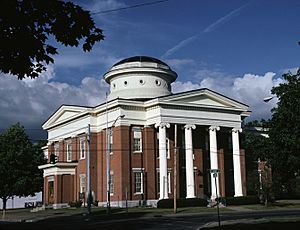
Oneida County Courthouse
|
|||
|
|||

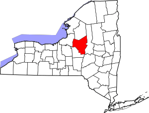
Location within the U.S. state of New York
|
|||
 New York's location within the U.S. |
|||
| Country | |||
| State | |||
| Founded | 1798 | ||
| Named for | Oneida people | ||
| Seat | Utica | ||
| Largest city | Utica | ||
| Area | |||
| • Total | 1,258 sq mi (3,260 km2) | ||
| • Land | 1,212 sq mi (3,140 km2) | ||
| • Water | 45 sq mi (120 km2) 3.6% | ||
| Population
(2020)
|
|||
| • Total | 226,654 | ||
| • Density | 191.5/sq mi (73.9/km2) | ||
| Time zone | UTC−5 (Eastern) | ||
| • Summer (DST) | UTC−4 (EDT) | ||
| Congressional district | 22nd | ||
Oneida County is a county in the state of New York, United States. As of February 2024, about 226,654 people live here. The main city and county seat is Utica.
The county is named after the Oneida people. They are one of the Five Nations of the Iroquois League, also known as the Haudenosaunee. This group lived in this area for a very long time before Europeans arrived. The Oneida Indian Nation still has a special land area, called a reservation, in the region. This reservation has been there since the late 1700s. Oneida County is part of the Mohawk Valley area of New York State. It is also part of the Utica–Rome, NY Metropolitan Statistical Area.
Contents
History of Oneida County
When England first set up counties in the Province of New York in 1683, the land that is now Oneida County was part of a very large area called Albany County. This huge county covered much of what is now New York State and even parts of Vermont.
Later, in 1772, Albany County was divided. A new part, called Tryon County, was created. This county covered the western part of New York. It was named after William Tryon, who was the governor at the time.
After the American Revolutionary War, in 1784, the name of Tryon County was changed to Montgomery County. This was done to honor General Richard Montgomery, a hero of the war.
Over the years, Montgomery County was divided many times to create new counties as more people moved into the area. In 1791, Herkimer County was formed from part of Montgomery County.
Then, in 1798, Oneida County was finally created from a part of Herkimer County. At first, Oneida County was even bigger than it is today. It included areas that are now Jefferson and Lewis counties. These counties were later separated from Oneida County in 1805.
Welsh Settlement and the Oneida Community
In the mid-1800s, Oneida County, especially around Utica, became an important place for Welsh people in New York. Many Welsh families moved here. They even had Welsh language newspapers, magazines, and churches. It was said that you could travel for miles and only hear people speaking Welsh! By 1855, about four thousand Welsh people lived in Oneida County.
In 1848, a man named John Humphrey Noyes started a special religious group called the Oneida Community. This community was near the town of Oneida. They had different ideas about religion and how people should live together. The community lasted until 1881. Later, the Oneida Silver Company was started here. This company became famous for making silverware.
Geography of Oneida County
Oneida County is in the central part of New York State. It is located east of Syracuse and west of Albany. The county covers about 1,258 square miles. Most of this is land, and about 45 square miles is water.
Oneida Lake is on the northwestern edge of the county. Part of the Adirondack Park is in the northeast. Also, a section of the Tug Hill Plateau is in the northern part of the county. The highest point in Oneida County is called Tassel Hill. It is in the southern part of the county, near the villages of Waterville and Cassville.
The Erie Canal, which was finished in 1825, runs through the county. It follows the Mohawk River from east to west. This canal helped a lot with trade and brought many new settlers to the area. Oneida Lake and Oneida Creek also form part of the county's western border.
Neighboring Counties
Oneida County shares borders with several other counties:
- Lewis County – to the north
- Herkimer County – to the east
- Otsego County – to the southeast
- Madison County – to the southwest
- Oswego County – to the west
National Protected Area
- Fort Stanwix National Monument is a special historical site in the county.
People of Oneida County
| Historical population | |||
|---|---|---|---|
| Census | Pop. | %± | |
| 1800 | 22,047 | — | |
| 1810 | 33,792 | 53.3% | |
| 1820 | 50,997 | 50.9% | |
| 1830 | 71,326 | 39.9% | |
| 1840 | 85,310 | 19.6% | |
| 1850 | 99,566 | 16.7% | |
| 1860 | 105,202 | 5.7% | |
| 1870 | 110,008 | 4.6% | |
| 1880 | 115,475 | 5.0% | |
| 1890 | 122,922 | 6.4% | |
| 1900 | 132,800 | 8.0% | |
| 1910 | 154,157 | 16.1% | |
| 1920 | 182,833 | 18.6% | |
| 1930 | 198,763 | 8.7% | |
| 1940 | 203,636 | 2.5% | |
| 1950 | 222,855 | 9.4% | |
| 1960 | 264,401 | 18.6% | |
| 1970 | 273,037 | 3.3% | |
| 1980 | 253,466 | −7.2% | |
| 1990 | 250,836 | −1.0% | |
| 2000 | 235,469 | −6.1% | |
| 2010 | 234,878 | −0.3% | |
| 2020 | 232,125 | −1.2% | |
| U.S. Decennial Census 1790-1960 1900-1990 1990-2000 2010-2020 |
|||
In 2000, there were about 235,469 people living in Oneida County. The population density was about 194 people per square mile. Most people in the county were White (90.21%), with a smaller number of African American (5.74%), Asian (1.16%), and Native American (0.23%) residents. About 3.20% of the population was Hispanic or Latino.
Many people in Oneida County have roots from different parts of the world. In 2000, common backgrounds included Italian (21.7%), Irish (13.1%), German (12.1%), Polish (9.9%), and English (8.5%). Most people (90.6%) spoke English at home.
The population in 2000 was spread out by age. About 23.90% were under 18 years old, and 16.50% were 65 or older. The average age was 38 years.
2020 Census Information
| Race | Num. | Perc. |
|---|---|---|
| White (NH) | 180,984 | 78.0% |
| Black or African American (NH) | 14,989 | 7.0% |
| Native American (NH) | 508 | 0.22% |
| Asian (NH) | 10,522 | 4.53% |
| Pacific Islander (NH) | 72 | 0.03% |
| other/mixed (NH) | 9,859 | 4.3% |
| Hispanic or Latino | 15,191 | 6.54% |
Economy of Oneida County
In the past, the main product made in Oneida County was silverware. This was mostly done at the Oneida Ltd. company in Sherrill. However, in 2005, the company stopped making silverware there and sold its factories. Today, a new company owns the factory and still makes American-made silverware under the Liberty Tabletop brand.
Currently, one of the biggest parts of Oneida County's economy is gambling and tourism. The Turning Stone Casino Resort is owned by the Oneida Indian Nation of New York. It is the largest private employer in Oneida County, meaning it provides the most jobs outside of government or healthcare.
Education in Oneida County
Oneida County has several places for higher education and many public schools.
Colleges and Universities
- Hamilton College
- Mohawk Valley Community College
- State University of New York Polytechnic Institute
- Utica University
Public School Districts
- Adirondack Central School District
- Brookfield Central School District
- Camden Central School District
- Central Square Central School District
- Clinton Central School District
- Holland Patent Central School District
- Madison Central School District
- Mount Markham Central School District
- New Hartford Central School District
- New York Mills Union Free School District
- Oneida City School District
- Oriskany Central School District
- Poland Central School District
- Remsen Central School District
- Rome City School District
- Sauquoit Valley Central School District
- Sherrill City School District
- Stockbridge Valley Central School District
- Utica City School District
- Waterville Central School District
- Town of Webb Union Free School District
- West Canada Valley Central School District
- Westmoreland Central School District
- Whitesboro Central School District
State-Operated Schools
- New York State School for the Deaf
Communities in Oneida County
Oneida County has several different types of communities, including cities, towns, and villages.
Cities
Towns
Villages
Census-Designated Places (CDPs)
- Barneveld
- Bridgewater
- Chadwicks
- Clark Mills
- Durhamville
- Hamilton College
- Lake Delta
- Marcy
- North Bay
- Otter Lake
- Prospect
- Stittville
- Verona
- Washington Mills
- Westernville
- Westmoreland
- White Lake
Hamlets
- Blossvale
- Cassville
- Deansboro
- Jewell
- Lee Center
- Lower South Bay
- McConnellsville
- Point Rock
- Sauquoit
- Taberg
- Vernon Center
- Verona Mills
Notable Locations
- Fort Stanwix
- Oriskany Battlefield State Historic Site
- Steuben Memorial State Historic Site
See also
 In Spanish: Condado de Oneida (Nueva York) para niños
 | Sharif Bey |
 | Hale Woodruff |
 | Richmond Barthé |
 | Purvis Young |


