Lewis County, New York facts for kids
Quick facts for kids
Lewis County
|
|||
|---|---|---|---|

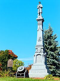
Lewis County Soldiers' and Sailors' Monument
|
|||
|
|||

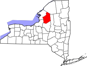
Location within the U.S. state of New York
|
|||
 New York's location within the U.S. |
|||
| Country | |||
| State | |||
| Founded | 1805 | ||
| Named for | Morgan Lewis | ||
| Seat | Lowville | ||
| Largest village | Lowville | ||
| Area | |||
| • Total | 1,290 sq mi (3,300 km2) | ||
| • Land | 1,275 sq mi (3,300 km2) | ||
| • Water | 15 sq mi (40 km2) 1.2% | ||
| Population
(2020)
|
|||
| • Total | 26,582 | ||
| • Density | 20.8/sq mi (8.0/km2) | ||
| Time zone | UTC−5 (Eastern) | ||
| • Summer (DST) | UTC−4 (EDT) | ||
| Congressional district | 21st | ||
Lewis County is a cool place in New York State. In 2020, about 26,582 people lived here. This makes it one of the less crowded counties in New York. Its main town, or "county seat," is Lowville.
Lewis County is named after Morgan Lewis. He was the Governor of New York when the county was created. Lewis County is part of a bigger area in New York called the "North Country".
Contents
History of Lewis County
The land that is now Lewis County was mostly empty until the late 1700s. The Province of New York claimed this land. But it was also part of the territory of the Iroquois Native American groups. After the American Revolutionary War, New York took control of these lands. This happened because some tribes had supported the British.
The land was not properly mapped or settled for a while. Then, in 1791, a big land deal called Macomb's Purchase happened. This deal put much of the land into the hands of a man named John Brown.
How Lewis County's Borders Changed
The area of Lewis County has been part of many different counties over time.
- It started as part of the huge Albany County in 1683.
- Then, it became part of Tryon County in 1772.
- Tryon County was renamed Montgomery County in 1784.
- Next, it was part of Herkimer County in 1791.
- It then became part of Oneida County in 1798.
- Finally, in 1805, Lewis County got its current name and borders.
When New York State first set up counties in 1683, Albany County was enormous. It covered much of northern New York and even parts of what is now Vermont. Over the years, this huge county was split into smaller ones.
In 1772, Albany County was divided again. One new part was Tryon County. This county was named after William Tryon, who was the colonial governor of New York. After the American Revolutionary War, in 1784, Tryon County was renamed Montgomery County. This was to honor Richard Montgomery, an American general.
In 1791, Herkimer County was created from Montgomery County. This new county was also very large. Later, in 1798, Oneida County was formed from Herkimer County. Finally, in 1805, Lewis County was officially created from Oneida County.
Lewis County's Role in Wars
In 1805, a group called the Militia of Lewis, Jefferson, and St. Lawrence was formed. It was known as the 26th Brigade.
During the War of 1812, Lewis County played a part. In 1812, a company of soldiers from Lewis County served at Sackett's Harbor. They helped in the First Battle of Sacket's Harbor. More men were called up from the county to help with the war effort in 1813 and 1814.
Geography of Lewis County
Lewis County is in northwestern New York State. It's a bit northeast of Syracuse. The eastern part of the county is inside the beautiful Adirondack Park. A large part of the Tug Hill Plateau is in the western area. This means Lewis County is right in the middle of the "Snowbelt". This area gets a lot of snow! The county is also home to the Black River Valley.
Neighboring Counties
Lewis County shares borders with these other counties:
- St. Lawrence County to the north
- Herkimer County to the east
- Oneida County to the south
- Oswego County to the west
- Jefferson County to the northwest
Getting Around Lewis County
Here are some of the main roads that go through Lewis County:
People of Lewis County
| Historical population | |||
|---|---|---|---|
| Census | Pop. | %± | |
| 1810 | 6,433 | — | |
| 1820 | 9,227 | 43.4% | |
| 1830 | 15,239 | 65.2% | |
| 1840 | 17,830 | 17.0% | |
| 1850 | 24,564 | 37.8% | |
| 1860 | 28,580 | 16.3% | |
| 1870 | 28,699 | 0.4% | |
| 1880 | 31,416 | 9.5% | |
| 1890 | 29,806 | −5.1% | |
| 1900 | 27,427 | −8.0% | |
| 1910 | 24,849 | −9.4% | |
| 1920 | 23,704 | −4.6% | |
| 1930 | 23,447 | −1.1% | |
| 1940 | 22,815 | −2.7% | |
| 1950 | 22,521 | −1.3% | |
| 1960 | 23,249 | 3.2% | |
| 1970 | 23,644 | 1.7% | |
| 1980 | 25,035 | 5.9% | |
| 1990 | 26,796 | 7.0% | |
| 2000 | 26,944 | 0.6% | |
| 2010 | 27,087 | 0.5% | |
| 2020 | 26,582 | −1.9% | |
| U.S. Decennial Census 1790-1960 1900-1990 1990-2000 2010-2020 |
|||
In 2000, about 26,944 people lived in Lewis County. Most people (98.17%) were White. A small number were African American, Native American, or Asian. About 0.64% of the population was Hispanic or Latino.
Many people in Lewis County have German, French, Irish, English, American, or Polish family backgrounds. Most people (97.3%) spoke English as their first language.
The average age of people in the county was 37 years old. About 27.8% of the population was under 18.
2020 Census Information
| Race | Num. | Perc. |
|---|---|---|
| White (NH) | 24,942 | 93.83% |
| Black or African American (NH) | 103 | 0.39% |
| Native American (NH) | 40 | 0.15% |
| Asian (NH) | 65 | 0.24% |
| Pacific Islander (NH) | 11 | 0.04% |
| Other/Mixed (NH) | 961 | 3.61% |
| Hispanic or Latino | 460 | 1.73% |
Towns and Villages in Lewis County
Lewis County has several towns and villages. The largest settlement is Lowville.
Bigger Towns and Villages
| # | Location | Population | Type | Sector |
|---|---|---|---|---|
| 1 | †Lowville | 3,470 | Village | Center |
| 2 | Copenhagen | 841 | Village | Northwest |
| 3 | Port Leyden | 672 | Village | Southeast |
| 4 | ††Harrisville | 628 | CDP | North |
| 5 | Croghan | 618 | Village | East |
| 6 | Lyons Falls | 566 | Village | Southeast |
| 7 | Castorland | 351 | Village | Northwest |
| 8 | Constableville | 242 | Village | Southwest |
| 9 | Turin | 232 | Village | Southeast |
† - County Seat
†† - Former Village
All Towns in Lewis County
Small Communities (Hamlets)
Famous People from Lewis County
- Peter Ostrum (born 1957) is a former child actor. He played Charlie Bucket in Willy Wonka & the Chocolate Factory. He later became a veterinarian and settled in Lowville.
- Fred A. Young (1904–1973) was a well-known politician and judge. He was born and lived most of his life in Lowville.
- Florence Augusta Merriam Bailey (1863–1948) was an American expert on birds and nature writer. She was born in Locust Grove, New York.
- Franklin B. Hough (1822–1885) was a scientist and historian. He was the first chief of the United States Division of Forestry, which later became the U.S. Forest Service. He was born in Martinsburg.
- Clinton Hart Merriam (1855–1942) was an American zoologist, ornithologist (bird expert), and naturalist.
- Edward McGlachlin (1840–1931) was an American newspaper editor and politician. He was born in Watson.
See also
 In Spanish: Condado de Lewis (Nueva York) para niños
 | Kyle Baker |
 | Joseph Yoakum |
 | Laura Wheeler Waring |
 | Henry Ossawa Tanner |


