
Lowville, New York facts for kids
Quick facts for kids
Lowville, New York
|
|
|---|---|

Lowville, New York
Location in New York
|
|
| Country | United States |
| State | New York |
| County | Lewis |
| Settled | 1797 |
| Established | 1800 |
| Area | |
| • Total | 38.13 sq mi (98.74 km2) |
| • Land | 37.83 sq mi (97.99 km2) |
| • Water | 0.29 sq mi (0.75 km2) |
| Elevation | 1,240 ft (380 m) |
| Population
(2020)
|
|
| • Total | 4,888 |
| • Estimate
(2016)
|
5,233 |
| • Density | 129.91/sq mi (50.16/km2) |
| Time zone | UTC-5 (Eastern (EST)) |
| • Summer (DST) | UTC-4 (EDT) |
| ZIP code |
13367
|
| Area code(s) | 315 |
| FIPS code | 36-049-43731 |
| GNIS feature ID | 979171 |
Lowville /ˈlaʊvɪl/ is a town in Lewis County, New York, United States. In 2020, about 4,888 people lived there. The town is located near the center of Lewis County. It is southeast of the city of Watertown.
The town of Lowville includes a village also called Lowville. This village is the main government center, known as the county seat. The town was named after Nicholas Low, who owned a lot of land there a long time ago. He came from a village near Amsterdam in 1778. The name "Lowville" does not mean it's a low place or that there are many cows.
Contents
History of Lowville
People first settled in Lowville in 1798. They came from Westfield, Massachusetts. The town was officially formed in 1800. It was created from a part of the town of Mexico in Oswego County. Later, in 1803, a part of Lowville became the town of Harrisburg.
The village of Lowville became a separate official village in 1854. In 1864, it became the county seat, taking over from Martinsburg.
Early Settlers and Mills
Daniel Kelley and his six sons moved to Lowville in 1798 from Middletown, Connecticut. Daniel and others built a sawmill and a two-story house. One of his sons, Datus, worked at the mill.
In 1867, Datus' daughter, Emeline (Kelley) Huntington, wrote about the old mill. She said it was still working by a small brook. The mill helped grind wheat and corn for the local people.
In 1810, Datus married Sara Dean. They moved to Rockport, Ohio. Later, Datus and Sara bought Kelleys Island in Lake Erie (Ohio). They started a community there called Kelley's Island.
Growth and Industries
Farming, especially dairy farming, grew well in Lowville. This was because the soil near the Black River was very rich.
Transportation also helped Lowville grow:
- The Black River Canal opened in 1851.
- The Rome, Watertown and Ogdensburg Railroad started in 1867.
- The Lowville and Beaver Railroad began in 1906.
These transport links helped industries to thrive. Some important companies in Lowville include:
- QubicaAMF: This company is the world's largest maker of bowling pins.
- Kraft: This plant is the largest cream cheese factory in the country.
Maple Ridge Wind Farm
The Maple Ridge Wind Farm opened in 2006. It is one of the biggest wind farms in the United States. It has 195 wind turbines. These turbines can produce 320 megawatts of power. This is enough electricity for many homes.
The wind farm helps the local community a lot. It provides about $10 million in benefits each year. Around $2 million goes to 75 landowners. Another $8 million goes to the region in taxes. This project has increased New York's renewable energy by six times. The wind farm is owned by Iberdrola Renewables and EDP Renewables North America.
Famous Residents
Peter Ostrum, who played Charlie Bucket in the movie Willy Wonka and the Chocolate Factory, lives in Lowville. He works there as a veterinarian.
Geography of Lowville
The United States Census Bureau says that Lowville covers about 38.1 square miles (99 km2) (98.7 square kilometers). Most of this area, about 37.8 square miles (98 km2) (98.0 square kilometers), is land. A small part, about 0.3 square miles (0.78 km2) (0.75 square kilometers), is water.
Roads and Rivers
Several main roads pass through Lowville:
- New York State Route 177 ends at New York State Route 12 in Lowville.
- New York State Route 26 and New York State Route 812 also go through the town.
The Black River flows along the eastern side of the town.
Climate in Lowville
Lowville has a humid continental climate. This means it has warm summers and cold, snowy winters. July is usually the warmest month. January is the coldest. Winters get a lot of snow because Lowville is close to Lake Ontario.
| Climate data for Lowville, New York (1991–2020 normals, extremes 1892–present) | |||||||||||||
|---|---|---|---|---|---|---|---|---|---|---|---|---|---|
| Month | Jan | Feb | Mar | Apr | May | Jun | Jul | Aug | Sep | Oct | Nov | Dec | Year |
| Record high °F (°C) | 64 (18) |
66 (19) |
81 (27) |
89 (32) |
92 (33) |
99 (37) |
100 (38) |
98 (37) |
95 (35) |
87 (31) |
77 (25) |
67 (19) |
100 (38) |
| Mean maximum °F (°C) | 50.4 (10.2) |
48.4 (9.1) |
59.6 (15.3) |
75.4 (24.1) |
83.2 (28.4) |
87.1 (30.6) |
88.4 (31.3) |
87.8 (31.0) |
84.5 (29.2) |
75.9 (24.4) |
65.1 (18.4) |
53.2 (11.8) |
90.1 (32.3) |
| Mean daily maximum °F (°C) | 26.6 (−3.0) |
28.8 (−1.8) |
37.5 (3.1) |
52.0 (11.1) |
65.8 (18.8) |
74.0 (23.3) |
78.4 (25.8) |
77.2 (25.1) |
70.1 (21.2) |
56.7 (13.7) |
44.0 (6.7) |
32.5 (0.3) |
53.6 (12.0) |
| Daily mean °F (°C) | 17.3 (−8.2) |
19.1 (−7.2) |
28.0 (−2.2) |
41.8 (5.4) |
54.5 (12.5) |
63.4 (17.4) |
67.8 (19.9) |
66.2 (19.0) |
58.6 (14.8) |
47.1 (8.4) |
35.7 (2.1) |
24.7 (−4.1) |
43.7 (6.5) |
| Mean daily minimum °F (°C) | 8.0 (−13.3) |
9.4 (−12.6) |
18.5 (−7.5) |
31.6 (−0.2) |
43.2 (6.2) |
52.7 (11.5) |
57.3 (14.1) |
55.2 (12.9) |
47.2 (8.4) |
37.5 (3.1) |
27.5 (−2.5) |
16.8 (−8.4) |
33.7 (1.0) |
| Mean minimum °F (°C) | −18.4 (−28.0) |
−12.7 (−24.8) |
−4.3 (−20.2) |
18.6 (−7.4) |
29.7 (−1.3) |
39.6 (4.2) |
46.4 (8.0) |
43.1 (6.2) |
32.6 (0.3) |
23.8 (−4.6) |
9.8 (−12.3) |
−8.1 (−22.3) |
−21.5 (−29.7) |
| Record low °F (°C) | −37 (−38) |
−36 (−38) |
−25 (−32) |
4 (−16) |
20 (−7) |
28 (−2) |
35 (2) |
29 (−2) |
22 (−6) |
9 (−13) |
−15 (−26) |
−40 (−40) |
−40 (−40) |
| Average precipitation inches (mm) | 3.47 (88) |
2.59 (66) |
2.65 (67) |
3.11 (79) |
3.39 (86) |
3.72 (94) |
3.48 (88) |
3.80 (97) |
3.49 (89) |
4.56 (116) |
3.75 (95) |
3.82 (97) |
41.83 (1,062) |
| Average snowfall inches (cm) | 35.6 (90) |
29.6 (75) |
15.8 (40) |
4.1 (10) |
0.2 (0.51) |
0.0 (0.0) |
0.0 (0.0) |
0.0 (0.0) |
0.0 (0.0) |
0.4 (1.0) |
9.4 (24) |
31.9 (81) |
127.0 (323) |
| Average extreme snow depth inches (cm) | 15.9 (40) |
17.1 (43) |
13.4 (34) |
4.0 (10) |
0.1 (0.25) |
0.0 (0.0) |
0.0 (0.0) |
0.0 (0.0) |
0.0 (0.0) |
0.5 (1.3) |
4.8 (12) |
12.9 (33) |
21.8 (55) |
| Average precipitation days (≥ 0.01 in) | 18.1 | 15.1 | 13.4 | 13.6 | 13.3 | 12.2 | 10.9 | 10.7 | 11.5 | 14.3 | 14.9 | 18.0 | 166.0 |
| Average snowy days (≥ 0.1 in) | 16.4 | 13.9 | 9.1 | 3.1 | 0.2 | 0.0 | 0.0 | 0.0 | 0.0 | 0.4 | 5.2 | 12.8 | 61.1 |
| Source 1: NOAA | |||||||||||||
| Source 2: National Weather Service | |||||||||||||
People in Lowville
| Historical population | |||
|---|---|---|---|
| Census | Pop. | %± | |
| 1820 | 1,943 | — | |
| 1830 | 2,334 | 20.1% | |
| 1840 | 2,047 | −12.3% | |
| 1850 | 2,377 | 16.1% | |
| 1860 | 2,373 | −0.2% | |
| 1870 | 2,805 | 18.2% | |
| 1880 | 3,188 | 13.7% | |
| 1890 | 3,634 | 14.0% | |
| 1900 | 3,746 | 3.1% | |
| 1910 | 3,875 | 3.4% | |
| 1920 | 3,915 | 1.0% | |
| 1930 | 4,336 | 10.8% | |
| 1940 | 4,586 | 5.8% | |
| 1950 | 4,623 | 0.8% | |
| 1960 | 4,635 | 0.3% | |
| 1970 | 4,754 | 2.6% | |
| 1980 | 4,575 | −3.8% | |
| 1990 | 4,849 | 6.0% | |
| 2000 | 4,548 | −6.2% | |
| 2010 | 4,982 | 9.5% | |
| 2020 | 4,888 | −1.9% | |
| U.S. Decennial Census | |||
In 2000, there were 4,548 people living in Lowville. There were 1,796 households, and 1,172 families. About 32.6% of households had children under 18. About 52.3% were married couples.
The average age of people in Lowville was 40 years old. For every 100 females, there were about 87 males.
Festivals and Events
Lowville holds an annual festival to celebrate the World's Largest Cheesecake. This giant cheesecake was made by Kraft in Lowville.
Communities and Locations
- Dadville – A small community northeast of Lowville village. It is located on NY-812 near the Black River.
- Lowville – This is the main village in the eastern part of the town.
- Mill Creek – A stream that flows east through Lowville village into the Black River.
- Smiths Landing – This was a community that used to be on the Black River shore.
- Stows Square – This was another community that used to be north of Lowville village.
- West Lowville – A community in the northwest part of the town. It is where Routes NY-12 and NY-177 meet.
Images for kids
-
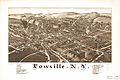
A map of Lowville from 1885, showing landmarks.
-
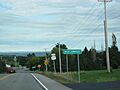
West Lowville as seen from New York State Route 177.


See also
 In Spanish: Lowville (pueblo) para niños
