
Westmoreland, New York facts for kids
Quick facts for kids
Westmoreland
|
|
|---|---|

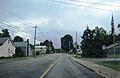
Southbound NY 233 in Westmoreland
|
|
_highlighted.svg)
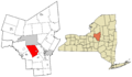
Location in Oneida County and the state of New York
|
|
.svg)
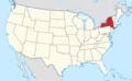
Location of New York in the United States
|
|
| Country | United States |
| State | New York |
| County | Oneida |
| Area | |
| • Total | 43.15 sq mi (111.76 km2) |
| • Land | 43.14 sq mi (111.72 km2) |
| • Water | 0.01 sq mi (0.04 km2) |
| Population
(2010)
|
|
| • Total | 6,138 |
| • Estimate
(2016)
|
6,086 |
| • Density | 141.09/sq mi (54.48/km2) |
| Time zone | EST |
| • Summer (DST) | EDT |
| FIPS code | 36-065-80533 |
Westmoreland is a small town located in Oneida County, New York, in the United States. In 2010, about 6,138 people lived there. This town is in the west-central part of Oneida County. The main highway, the New York State Thruway (also known as Interstate 90), goes right through Westmoreland. The town is located to the west of a larger city called Utica.
Contents
History of Westmoreland
Westmoreland was first settled in 1748. A missionary named James Dean was among the first people to live there. He worked with the Oneida tribe.
The Town of Westmoreland was officially created in 1792. It was formed from a larger area called the Town of Whitestown. Over the years, parts of Westmoreland were used to create other towns. In 1802, the towns of Vernon and Verona were formed from Westmoreland. Later, in 1855, another part of Westmoreland was used to create the Town of Kirkland to the south.
Geography of Westmoreland
Westmoreland covers a total area of about 43.2 square miles (111.76 square kilometers). Most of this area is land, about 43.1 square miles (111.72 square kilometers). Only a very small part, about 0.04 square miles (0.01 square kilometers), is water.
Population and People in Westmoreland
| Historical population | |||
|---|---|---|---|
| Census | Pop. | %± | |
| 1800 | 1,542 | — | |
| 1810 | 1,135 | −26.4% | |
| 1820 | 2,791 | 145.9% | |
| 1830 | 3,303 | 18.3% | |
| 1840 | 3,105 | −6.0% | |
| 1850 | 3,292 | 6.0% | |
| 1860 | 3,166 | −3.8% | |
| 1870 | 2,952 | −6.8% | |
| 1880 | 2,744 | −7.0% | |
| 1890 | 2,313 | −15.7% | |
| 1900 | 2,192 | −5.2% | |
| 1910 | 1,995 | −9.0% | |
| 1920 | 1,984 | −0.6% | |
| 1930 | 2,170 | 9.4% | |
| 1940 | 2,235 | 3.0% | |
| 1950 | 2,811 | 25.8% | |
| 1960 | 4,084 | 45.3% | |
| 1970 | 5,093 | 24.7% | |
| 1980 | 5,458 | 7.2% | |
| 1990 | 5,737 | 5.1% | |
| 2000 | 6,213 | 8.3% | |
| 2010 | 6,138 | −1.2% | |
| 2016 (est.) | 6,086 | −0.8% | |
| U.S. Decennial Census | |||
In the year 2000, there were 6,207 people living in Westmoreland. These people lived in 2,234 households, and 1,717 of these were families. The town had about 143.9 people per square mile. There were 2,323 houses or living spaces.
Most of the people in Westmoreland were White (98.15%). A smaller number were African American (0.69%), Native American (0.24%), or Asian (0.29%). About 0.95% of the population was Hispanic or Latino.
About 37% of the households had children under 18 living with them. Most households (64.8%) were married couples living together. About 18.7% of all households were people living alone. The average household had 2.75 people.
The population was spread out by age. About 27.6% were under 18 years old. About 12.6% were 65 years or older. The average age in the town was 38 years.
In 2000, the average income for a household in Westmoreland was $48,768. For families, the average income was $52,257. About 5.1% of all people in the town lived below the poverty line. This included 5.7% of those under 18 and 3.5% of those 65 or older.
Communities and Places in Westmoreland
The Town of Westmoreland has several smaller communities and locations within its borders:
- Bartlett – This is a small village located northwest of Westmoreland village. It is north of the Thruway.
- Dix (formerly called "Republican") – You can find this small village near the northern border of the town.
- Goodrich Corners – This is another small village close to the western border of the town.
- Greenway Corners – This small village is in the very northwestern part of the town.
- Hecla – This village is southwest of Westmoreland village. It used to be known as "Hecla Works."
- Lairdsville – This small village is located near the southern border of the town, along NY Route 5.
- Lowell – A small village found on NY Route 26, north of the Thruway.
- Spencer Settlement – This small village is also on NY Route 26, just north of Lowell.
- Westmoreland – This is the main village of Westmoreland. It was once called "Hampton." It is located on NY Route 233, south of the Thruway.
Education in Westmoreland
The Westmoreland Central School District serves all the students in the town. This school system includes:
- An elementary school for grades K-2.
- An upper elementary school for grades 3-6.
- A junior-senior high school for grades 7-12.
The school district also has a sports program for students.
Images for kids
-
Southbound NY 233 in Westmoreland
-
Location in Oneida County and the state of New York
-
Location of New York in the United States
See also
 In Spanish: Westmoreland (Nueva York) para niños
