Whitestown, New York facts for kids
Quick facts for kids
Whitestown, New York
|
||
|---|---|---|

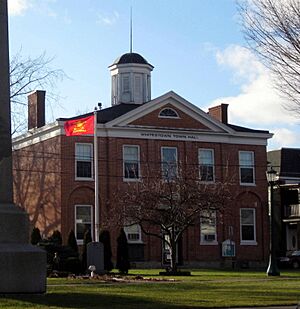
Whitestown Town Hall
|
||
|
||

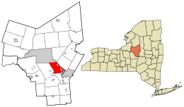
Location in Oneida County and the state of New York.
|
||
| Country | United States | |
| State | New York | |
| County | Oneida | |
| Government | ||
| • Type | Town Council | |
| Area | ||
| • Total | 27.32 sq mi (70.76 km2) | |
| • Land | 27.32 sq mi (70.75 km2) | |
| • Water | 0.00 sq mi (0.00 km2) | |
| Elevation | 479 ft (146 m) | |
| Population
(2010)
|
||
| • Total | 18,667 | |
| • Estimate
(2016)
|
18,474 | |
| • Density | 676.26/sq mi (261.10/km2) | |
| Time zone | UTC-5 (Eastern (EST)) | |
| • Summer (DST) | UTC-4 (EDT) | |
| ZIP code |
13492
|
|
| Area code(s) | 315 | |
| FIPS code | 36-81754 | |
| GNIS feature ID | 0979638 | |
Whitestown is a town located in Oneida County, New York, in the United States. In 2010, about 18,667 people lived there. The town is named after Judge Hugh White, who was one of the first people to settle in the area. Whitestown is just west of Utica, and the New York State Thruway (which is Interstate 90) goes right through it.
Contents
The Story of Whitestown
The area that became Whitestown was first settled in 1784. The town itself was officially created in 1788. This was even before Oneida County was formed! Hugh White explored the land in 1784 by traveling along the Mohawk River. On June 5, 1784, he and his family found the mouth of the Sauquoit Creek. They decided to settle in the forests there, which later became Whitestown. Hugh White also played a big part in creating Oneida County in the 1790s.
Whitestown is often called the "Mother of Towns." This is because many other towns and counties were formed from its original large area. For example, the Town of Paris and the Town of Steuben were created from Whitestown in 1792. The Town of Cazenovia was formed in 1793, and the Town of Augusta in 1798. Later, Utica was formed in 1817, and the Town of New Hartford in 1827.
An important school called the Oneida Institute was located in Whitesboro, a village within Whitestown. It was special because it was the first school in the United States that allowed students of all races to learn together. It operated from 1827 to 1843.
Even though the old Whitestown Town Hall is in the village of Whitesboro, the current town offices are now located in the wider town of Whitestown, outside of the village.
Where is Whitestown?
Whitestown covers about 27.2 square miles (70.7 square kilometers) of land. It has very little water.
The town is located west of the City of Utica. Its northern border is along the Mohawk River. The Oriskany Creek also flows north through the town, eventually reaching the Mohawk River.
People of Whitestown
| Historical population | |||
|---|---|---|---|
| Census | Pop. | %± | |
| 1800 | 4,212 | — | |
| 1810 | 4,912 | 16.6% | |
| 1820 | 5,219 | 6.3% | |
| 1830 | 4,419 | −15.3% | |
| 1840 | 5,156 | 16.7% | |
| 1850 | 5,820 | 12.9% | |
| 1860 | 4,367 | −25.0% | |
| 1870 | 4,339 | −0.6% | |
| 1880 | 4,498 | 3.7% | |
| 1890 | 5,155 | 14.6% | |
| 1900 | 6,235 | 21.0% | |
| 1910 | 7,798 | 25.1% | |
| 1920 | 10,183 | 30.6% | |
| 1930 | 11,818 | 16.1% | |
| 1940 | 11,580 | −2.0% | |
| 1950 | 12,686 | 9.6% | |
| 1960 | 19,185 | 51.2% | |
| 1970 | 21,382 | 11.5% | |
| 1980 | 20,150 | −5.8% | |
| 1990 | 18,985 | −5.8% | |
| 2000 | 18,635 | −1.8% | |
| 2010 | 18,667 | 0.2% | |
| 2020 | 18,118 | −2.9% | |
| 2022 (est.) | 17,870 | −4.3% | |
| U.S. Decennial Census | |||
In 2000, there were 18,635 people living in Whitestown. There were about 7,544 households, which are groups of people living together. Most people in the town were White (about 97%). A smaller number were African American, Native American, or Asian. About 1.32% of the population was Hispanic or Latino.
The average household had about 2.39 people. About 28.8% of households had children under 18 living with them. The median age of people in the town was 40 years old.
Fun Places to Visit
- Mohawk Airlines – This airline used to have its main office at the Oneida County Airport in Whitestown. It no longer exists.
- Summit Park – This used to be a theme park in Oriskany, New York. It had rides, circuses, and animals. However, it closed in 1926 as people started traveling to bigger theme parks.
Communities and Neighborhoods
Whitestown is made up of several villages and smaller communities called hamlets.
Villages in Whitestown
- Oriskany – This village is located near the northern edge of the town.
- New York Mills – This village is southeast of Yorkville and close to Utica.
- Whitesboro – This village is in the eastern part of the town, south of the Thruway.
- Yorkville – This village is found on Route 5A, right between Utica and Whitesboro.
Hamlets in Whitestown
- Walesville – A small community in the southwestern part of the town.
- Coleman Mills – A hamlet located south of Oriskany and north of the Thruway.
- Dunham Manor – A place found south of Whitesboro.
- Glenhaven – A community near the southern border of the town.
- Herthum Heights – A location northwest of Whitesboro.
- Herthum Hills – A location west of Whitesboro.
- Sunset Manor – A community northwest of Whitesboro.
See also
 In Spanish: Whitestown (Nueva York) para niños
 | Ernest Everett Just |
 | Mary Jackson |
 | Emmett Chappelle |
 | Marie Maynard Daly |


