
Utica, New York facts for kids
Quick facts for kids
Utica
Unundadages (Mohawk)
|
|||||
|---|---|---|---|---|---|
|
City
|
|||||
|
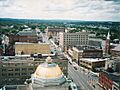
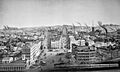
Panorama of downtown from I-790
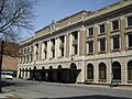
Liberty Bell Corner
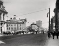
Looking south on Utica's Genesee Street
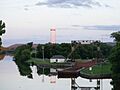
Utica Tower and harbor lock
|
|||||
|
|||||
| Nickname(s):
The Handshake City, Elm Tree City
|
|||||
 |
|||||
| Country | United States | ||||
| State | New York | ||||
| Region | Mohawk Valley | ||||
| Metro | Utica–Rome | ||||
| County | Oneida | ||||
| Land grant (village) | January 2, 1734 | ||||
| Incorporated (village) | April 3, 1798 | ||||
| Incorporated (city) | February 13, 1832 | ||||
| Government | |||||
| • Type | Strong mayor-council | ||||
| Area | |||||
| • City | 16.98 sq mi (43.97 km2) | ||||
| • Land | 16.72 sq mi (43.31 km2) | ||||
| • Water | 0.26 sq mi (0.66 km2) | ||||
| Elevation | 456 ft (139 m) | ||||
| Population
(2020)
|
|||||
| • City | 65,283 | ||||
| • Density | 3,904.02/sq mi (1,507.33/km2) | ||||
| • Urban | 117,328 (U.S.: 268th) | ||||
| • Metro | 297,592 (U.S.: 163rd) | ||||
| Demonym(s) | Utican | ||||
| GDP | |||||
| • Metro | .560 billion (2022) | ||||
| Time zone | UTC−5 (Eastern (EST)) | ||||
| • Summer (DST) | UTC−4 (EDT) | ||||
| ZIP Codes |
13501-13505, 13599
|
||||
| Area code(s) | 315 | ||||
| FIPS code | 36-76540 | ||||
| GNIS feature ID | 0968324 | ||||


Utica is a city in the Mohawk Valley of New York, United States. It is the main city of Oneida County. In 2020, about 65,283 people lived there, making it the tenth-largest city in New York State.
Utica is located by the Mohawk River and near the Adirondack Mountains. It is about 95 miles (153 km) west of Albany and 55 miles (89 km) east of Syracuse. Utica and the nearby city of Rome form the Utica–Rome Metropolitan Statistical Area.
Long ago, the Mohawk people lived here. Later, settlers from New England came after the American Revolution. In the 1800s, Utica became an important stop for travelers and goods. This was thanks to the Erie Canal and New York Central Railroad. It grew into a big center for making things, especially textiles (fabrics).
Like many older factory cities, Utica faced tough times in the mid-1900s. Factories closed, and people moved away. But because living costs are low, Utica has welcomed many refugees from different countries. This has helped the city grow again. It has also boosted its colleges, cultural places, and economy.
Contents
- What Does the Name "Utica" Mean?
- Utica's Past: A Look Back
- Where is Utica Located?
- Who Lives in Utica?
- Utica's Economy
- How Utica is Governed
- Utica's Culture and Fun
- Parks and Recreation
- Transportation and Services
- Learning in Utica
- Sports in Utica
- Media and Entertainment
- Famous People from Utica
- Images for kids
- See also
What Does the Name "Utica" Mean?
There are a few ideas about how Utica got its name. One story says that in 1798, people met at Bagg's Tavern. They picked the name "Utica" from a hat with 13 choices. Utica was chosen because it was the name of an ancient city in Tunisia. Many other New York cities also chose names from ancient Mediterranean places. For example, Troy, New York and Rome, New York did the same.
Utica's Past: A Look Back
Early Days: Native Americans and Settlers

Utica was built where Old Fort Schuyler once stood. English colonists built this fort in 1758 during the French and Indian War. This war was fought against France and its Native American allies. Before the fort, the Mohawk, Onondaga, and Oneida tribes lived here for thousands of years. The Mohawk were a strong tribe in the area. Colonists traded furs with them.
The land for the fort was given by King George II in 1734. The fort was important because it was near trails and a shallow part of the Mohawk River. This made it a good place to cross the river. The Mohawk people called this river bend Unundadages, meaning "around the hill." This Mohawk word is even on the city's seal.
During the American Revolution, British-allied Iroquois tribes attacked settlers. George Washington sent soldiers to stop these attacks. Many Iroquois villages were destroyed, leading to hunger. After the war, many European-American settlers moved to this area from New England.
In 1794, a road called Genesee Road was built. It helped connect Utica to other places. This road, and later the Seneca Turnpike, made Utica a key stop. It became a place for travelers and goods moving through Western New York.
Utica officially became a village on April 3, 1798. It grew its borders in 1805 and 1817. After the Erie Canal was finished in 1825, the city grew even more. In 1832, Utica became a city. By 1845, it was the 29th-largest city in the U.S. with 20,000 people. This was more than cities like Chicago or Detroit at the time.
Factories, Trade, and Freedom

Utica's location on the Erie and Chenango canals helped factories grow. They could easily bring in coal from Pennsylvania to power their machines. Utica made furniture, machines, textiles (fabrics), and lumber. The textile industry grew a lot, processing cotton from the Southern states.
Railroads also helped Utica's growth. The first line connected Utica to Schenectady in 1836. Later, other lines joined to form the New York Central Railroad. This made Utica a major transportation hub.
In the 1850s, Utica was a key stop on the Underground Railroad. This was a secret network that helped enslaved people escape to freedom. Over 650 enslaved people found help in Utica. The city was on a route that led to Canada. Famous abolitionists (people who wanted to end slavery) like Orange Scott spoke out against slavery in Utica.
Modern Utica: Changes and New Beginnings

In the early 1900s, trains became even more important in Utica. Electric train lines connected the city to Syracuse and Little Falls.
By the 1950s, Utica had some issues with local government. Many immigrants from Italy, Ireland, Poland, and Lebanon came to work in the city's factories.
Like other cities in the "Rust Belt" (older industrial areas that faced economic decline), Utica saw many factories close in the mid-1900s. The opening of the New York State Thruway in 1954, which went around the city, also affected its economy. Major companies like General Electric and Lockheed Martin closed their plants.
Many jobs moved to the suburbs around Utica. This caused the city's population to shrink. People who stayed faced challenges like poverty. However, Utica's low cost of living has attracted new immigrants and refugees. People from Bosnia, Vietnam, and other countries have made Utica their new home. This has helped the city's economy and cultural life.
In 2010, Utica created a new plan for its future. This plan aims to help the city grow and improve.
Where is Utica Located?


Utica covers about 17 square miles (44 square km). Most of this is land, with a small amount of water. The city is in the middle of New York State. It is next to Herkimer County, New York and at the base of the Adirondack Mountains. Utica is about 456 feet (139 meters) above sea level.
Utica's Landscape
The Mohawk name for the city, Unundadages, means "around the hill." This refers to a bend in the Mohawk River that flows around the city. The Erie Canal and Mohawk River run through northern Utica. Northwest of downtown is the Utica Marsh, a wetland area with many animals, plants, and birds. Utica is mostly flat, but its suburbs have more hills.

City Design and Buildings

Utica has many different building styles, like Greek Revival and Gothic Revival. The Utica State Office Building, built in 1972, is the tallest building at 17 floors.
Many streets in Utica are named after early settlers and landowners. Because the city is next to the Mohawk River, many streets run parallel to the river. This means they don't always run perfectly east-west or north-south.
Utica's Neighborhoods

Utica's neighborhoods have their own unique feel. Different groups of people have lived in them over time.
- West Utica was home to German, Irish, and Polish immigrants.
- The Corn Hill neighborhood had a large Jewish population.
- East Utica is a cultural and political center for Italian immigrants.
- The Triangle neighborhood north of downtown was home to African American and Jewish people.
Today, these neighborhoods are even more diverse. For example, Bosnian and Latin American people now live in areas that were once mainly Italian.
Historic Places to Visit
Many important places in Utica are listed on the National Register of Historic Places. These include:
- Calvary Episcopal Church
- First Presbyterian Church
- Grace Church
- Munson-Williams-Proctor Arts Institute
- St. Joseph's Church
- Stanley Theater
- Union Station
- Utica Public Library
- Utica State Hospital
Utica's Weather
Utica has four clear seasons. Winters are cold and snowy, with lots of snow from nearby Lake Erie and Lake Ontario. Summer days are warm, usually between 70–82°F (21-28°C). The city gets about 42 inches (107 cm) of rain each year.
| Climate data for Utica (Rome, New York), (1981–2010 normals, extremes 1893–present) | |||||||||||||
|---|---|---|---|---|---|---|---|---|---|---|---|---|---|
| Month | Jan | Feb | Mar | Apr | May | Jun | Jul | Aug | Sep | Oct | Nov | Dec | Year |
| Record high °F (°C) | 66 (19) |
62 (17) |
83 (28) |
91 (33) |
95 (35) |
99 (37) |
100 (38) |
97 (36) |
100 (38) |
89 (32) |
79 (26) |
71 (22) |
100 (38) |
| Mean daily maximum °F (°C) | 29.0 (−1.7) |
32.7 (0.4) |
41.8 (5.4) |
56.3 (13.5) |
68.3 (20.2) |
76.8 (24.9) |
81.1 (27.3) |
79.3 (26.3) |
70.9 (21.6) |
58.6 (14.8) |
46.5 (8.1) |
34.0 (1.1) |
56.4 (13.6) |
| Mean daily minimum °F (°C) | 12.1 (−11.1) |
14.1 (−9.9) |
22.4 (−5.3) |
34.7 (1.5) |
44.7 (7.1) |
54.1 (12.3) |
58.5 (14.7) |
57.5 (14.2) |
49.8 (9.9) |
38.2 (3.4) |
30.7 (−0.7) |
19.5 (−6.9) |
36.5 (2.5) |
| Record low °F (°C) | −31 (−35) |
−27 (−33) |
−27 (−33) |
0 (−18) |
22 (−6) |
31 (−1) |
41 (5) |
35 (2) |
27 (−3) |
16 (−9) |
1 (−17) |
−26 (−32) |
−31 (−35) |
| Average precipitation inches (mm) | 3.31 (84) |
2.61 (66) |
3.63 (92) |
3.45 (88) |
3.91 (99) |
4.20 (107) |
3.93 (100) |
3.81 (97) |
4.47 (114) |
4.25 (108) |
4.06 (103) |
4.10 (104) |
45.73 (1,162) |
| Average snowfall inches (cm) | 31.7 (81) |
23.4 (59) |
15.1 (38) |
3.4 (8.6) |
0.0 (0.0) |
0.0 (0.0) |
0.0 (0.0) |
0.0 (0.0) |
0.0 (0.0) |
0.1 (0.25) |
7.3 (19) |
20.8 (53) |
101.8 (258.85) |
| Average precipitation days (≥ 0.01 in) | 17.6 | 14.8 | 14.2 | 14.6 | 13.1 | 12.5 | 12.3 | 11.9 | 13.9 | 14.0 | 16.6 | 18.4 | 173.9 |
| Average snowy days (≥ 0.1 in) | 15.9 | 11.7 | 8.2 | 2.8 | 0.0 | 0.0 | 0.0 | 0.0 | 0.0 | 0.1 | 7.3 | 13.5 | 59.5 |
| Average relative humidity (%) | 66.0 | 66.2 | 65.0 | 64.1 | 63.3 | 66.8 | 66.0 | 68.2 | 72.7 | 69.8 | 72.3 | 72.3 | 67.9 |
| Percent possible sunshine | 42 | 46 | 52 | 58 | 64 | 66 | 65 | 60 | 54 | 48 | 43 | 40 | 53 |
| Source 1: NOAA | |||||||||||||
| Source 2: Weatherbase | |||||||||||||
Who Lives in Utica?
| Historical population | |||
|---|---|---|---|
| Census | Pop. | %± | |
| 1820 | 2,972 | — | |
| 1830 | 8,323 | 180.0% | |
| 1840 | 12,782 | 53.6% | |
| 1850 | 17,565 | 37.4% | |
| 1860 | 22,529 | 28.3% | |
| 1870 | 28,804 | 27.9% | |
| 1880 | 33,914 | 17.7% | |
| 1890 | 44,007 | 29.8% | |
| 1900 | 56,383 | 28.1% | |
| 1910 | 74,419 | 32.0% | |
| 1920 | 94,156 | 26.5% | |
| 1930 | 101,740 | 8.1% | |
| 1940 | 100,518 | −1.2% | |
| 1950 | 100,489 | 0.0% | |
| 1960 | 100,410 | −0.1% | |
| 1970 | 91,611 | −8.8% | |
| 1980 | 75,632 | −17.4% | |
| 1990 | 68,637 | −9.2% | |
| 2000 | 60,523 | −11.8% | |
| 2010 | 62,235 | 2.8% | |
| 2020 | 65,287 | 4.9% | |
| 2022 (est.) | 64,081 | 3.0% | |
| U.S. Decennial Census | |||
Utica's population grew a lot in the 1800s. In 1845, it had 20,000 people, more than Chicago or Detroit. Today, it is the tenth-largest city in New York.

Utica has always been a diverse city. Since the 1990s, many new immigrants and refugees have come. These include people from Bosnia, Myanmar (Burma), Latin America, Russia, and Vietnam. Over 42 languages are spoken in the city! This new wave of people helped Utica's population stop shrinking in 2010.
In 2020, Utica's population was 65,283. Italian Americans are still the largest ethnic group, making up about 20% of the city. Utica has historically had a very high number of Italian immigrants compared to other U.S. cities.
Other large groups include people of Slavic background (like Poles and Bosnians), Irish, African American, German, and Puerto Rican.
Utica's Economy
In the mid-1800s, Utica's canals and railroads helped its industries. Factories made furniture, train parts, firearms, textiles, and lumber. During World War I, a company called Savage Arms made weapons, and Utica became one of the wealthiest cities per person in the U.S.
In the early 1900s, the textile industry started to decline. Many jobs were lost as factories moved to the Southern U.S. where costs were lower. Other industries also left the city. New industries like electronics manufacturing (with companies like General Electric) and food processing grew.

Utica struggled to change its economy. The closing of defense companies like Lockheed Martin also hurt the city. However, the Mohawk Valley economy now focuses on logistics, industrial processes, and services. The former Griffiss Air Force Base in Rome is now a technology center. The Turning Stone Resort & Casino also brings tourists to the area.
Some of Utica's biggest employers today are the CONMED Corporation (which makes medical devices) and the Mohawk Valley Health System (the main healthcare provider). Construction projects also create jobs. The Erie Canal still helps transport heavy goods at a low cost.
How Utica is Governed
|
Government
 Utica City Hall
 The United States District Court for the Northern District of New York has offices in the Alexander Pirnie Federal Building
|
Utica has a "strong mayor-council" government. This means the mayor has a lot of power. Michael P. Galime, a Republican, became mayor in 2024. The city council has 10 members. Six are elected from specific areas, and four are elected by the whole city. The council has committees that work on things like transportation, education, and public safety.
Utica is part of New York's 22nd congressional district in the U.S. government. The city's police department keeps the city safe. The Utica Fire Department has a crew of 123 people and handles fires, rescues, and medical calls.
Utica's Culture and Fun

Utica is a mix of different cultures and traditions. It shares a similar way of speaking English with other cities in Central New York.
Utica has its own special foods, influenced by its many immigrant groups. You can find dishes like ćevapi (Bosnian sausages) and pasticciotti (Italian pastries). Some local favorites include chicken riggies, Utica greens, and tomato pie.

The Matt Brewing Company (Saranac Brewery) is a famous family-owned brewery in Utica. It is one of the largest craft breweries in the United States.
The annual Boilermaker Road Race is a 15 km (about 9.3 miles) race that attracts runners from all over the world. The Children's Museum of Natural History, Science and Technology has exhibits about science and space. The Munson-Williams-Proctor Arts Institute is an art museum and school.
The Stanley Center for the Arts is a beautiful old theater built in 1928. It hosts plays and concerts. The Hotel Utica, built in 1912, is a historic hotel that has hosted famous guests like Franklin D. Roosevelt. It was restored in 2001.
Parks and Recreation

Utica has over 677 acres of parks and recreation centers. Many parks have community centers and swimming pools. Frederick Law Olmsted Jr., who designed New York City's Central Park, also designed Utica's park system. He designed Memorial Parkway, a tree-lined road that connects many of the city's parks.
These parks include Roscoe Conkling Park, F.T. Proctor Park, and T.R. Proctor Park. The city's golf course, Valley View, is in the southern part of the city. The Utica Zoo and the Val Bialas Ski Chalet (an urban ski slope) are also in Roscoe Conkling Park. You can ski, snowboard, skate, and tube there.
The Utica Canal Terminal Harbor connects to the Erie Canal and Mohawk River.
Transportation and Services
Getting Around Utica

For air travel, Griffiss International Airport in Rome handles military and private planes. For regular passenger flights, people use Syracuse Hancock International Airport or Albany International Airport.
Amtrak trains stop at Utica's Union Station. Bus service is provided by CENTRO, which runs 12 lines in Utica. Other bus companies like Greyhound and Trailways also stop at Union Station.

Utica has several major highways. New York State Route 49 and New York State Route 840 are expressways that run along the city's northern and southern edges. New York State Route 5 and its alternate routes also pass through Utica. New York State Route 12 and New York State Route 8 form the North–South Arterial Highway.
City Services
Electricity in Utica is provided by National Grid. Utica is located near important electrical lines. The city's natural gas is also provided by National Grid.
The Oneida-Herkimer Solid Waste Authority handles trash and recycling. Utica's wastewater is treated by the Mohawk Valley Water Authority. The city's drinking water comes from the Hinckley Reservoir in the Adirondack Mountains.
Learning in Utica

Utica has a mix of public and private colleges. Three state colleges and four private colleges are in the Utica–Rome area.
- SUNY Polytechnic Institute is a state university with over 2,000 students.
- Mohawk Valley Community College is the largest college between Syracuse and Albany, with nearly 7,000 students.
- Utica University is a four-year private college with over 3,000 students.
- St. Elizabeth College of Nursing offers nursing degrees.
- The Pratt Institute has a satellite campus at the Munson-Williams-Proctor Arts Institute.

The Utica City School District serves nearly 10,000 students. It is the most diverse school district in Upstate New York. Schools include Thomas R. Proctor High School, James H. Donovan Middle School, John F Kennedy Middle School, and ten elementary schools. Notre Dame Junior Senior High School is a Catholic high school.

The first public library in Utica opened in 1838. The Utica Public Library building was finished in 1904. It is part of the Mid-York Library System.
Sports in Utica

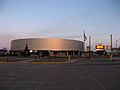
Utica is home to the Utica Comets, a professional ice hockey team. They play in the American Hockey League (AHL) and are linked with the National Hockey League's New Jersey Devils. The Comets play at the 3,815-seat Utica Memorial Auditorium, also known as "the Aud." The Aud also hosts the Utica University Pioneers hockey team. In April 2024, the 2024 IIHF Women's World Championship was held at the Aud.
Since 2018, Utica has also had Utica City FC, a professional indoor soccer team. They play in the Major Arena Soccer League.
The city used to have a baseball team called the Utica Blue Sox. Since 2008, there has been a collegiate summer baseball team also called the Blue Sox.
Local College Sports Teams
| School | Location | Nickname | Colors | Association | Conference | References |
|---|---|---|---|---|---|---|
| SUNY Polytechnic Institute | Marcy | Wildcats | Blue and gold | NCAA Division III | NEAC | |
| Hamilton College | Clinton | Continentals | Buff and blue | NCAA Division III | NESCAC | |
| Utica University | Utica | Pioneers | Navy and orange | NCAA Division III | Empire 8 | |
| Mohawk Valley Community College | Utica, Rome | Hawks | Forest green and white | NJCAA | Region III | |
| Herkimer County Community College | Herkimer | Generals | Hunter green and gold | NJCAA | Region III |
Media and Entertainment
Utica has several TV stations, including WKTV (NBC; CBS), WUTR (ABC), and WFXV (Fox; CW). There are also many FM and AM radio stations. The main newspapers are the Rome Sentinel and the Observer-Dispatch.
Utica has been featured in movies and TV shows. For example, the movie Slap Shot (1977) was partly filmed in Utica. The city has also appeared on the TV series The Office.
Famous People from Utica
Images for kids
-

Panorama of downtown from I-790
-
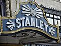
Stanley Theater
-
Liberty Bell Corner
-
Looking south on Utica's Genesee Street
-
Utica Tower and harbor lock
-
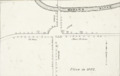
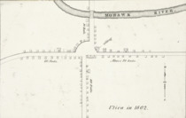
An 1802 engraved map of Utica. The Mohawk River is at the top, and Bagg's Tavern is at the center right.
-
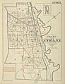
This 1883 index map shows the development around Utica and Bagg's Square, with the Erie Canal (now Oriskany Street) and Chenango Canal towards the upper-right.
-
Bird's-eye view of Utica over Bagg's Square in the 1850s, showing the smoke from numerous factory chimneys
-
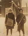
Newsboys for the Utica Saturday Globe, 1910
-
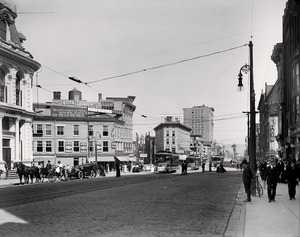
Looking north towards the corner of Genesee and Bleecker streets, c. 1900–1915. Streetcars can be seen crossing a bridge over the Erie Canal.
-
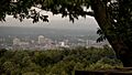
Utica as viewed from the northern hills of the city
-
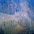
November 1985 photo of the Mohawk Valley from Space Shuttle Challenger, with Utica center-left and Albany center-right
-
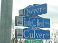
Eighteenth- and 19th-century families, individuals and landowners are evoked by many Utica street names.
-

The Utica Marsh is a series of wetlands north of the city.
-
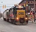
A CSX train sharing Schuyler Street in West Utica
-
The Bosnian Islamic Association of Utica's mosque near City Hall.
-

Fermentation tanks at the Matt Brewing Company in West Utica, producer of Saranac beer
-

Participants in Utica's annual Boilermaker Road Race
-

A skillet of Utica greens
-

Roscoe Conkling Park
-
Union Station
-
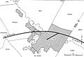
Early Federal Highway Administration map of the Interstate Highway System in Utica; Interstates 90 and 790 are in the shaded portion
-

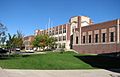
Aerial view of SUNY Polytechnic Institute from south to north
-
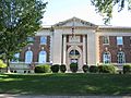
Thomas R. Proctor High School
-
Utica Public Library
-
Adirondack Bank Center after renovations, 2016
See also
 In Spanish: Utica (Nueva York) para niños
