
Kirkland, New York facts for kids
Quick facts for kids
Kirkland, New York
|
|
|---|---|

Lumbard Hall, Clinton, NY, which houses both the Kirkland Town Hall and the offices of the village of Clinton.
|
|

Location in Oneida County and the state of New York.
|
|
| Country | United States |
| State | New York |
| County | Oneida |
| Government | |
| • Type | Town Council |
| Area | |
| • Total | 33.81 sq mi (87.57 km2) |
| • Land | 33.76 sq mi (87.44 km2) |
| • Water | 0.05 sq mi (0.13 km2) |
| Elevation | 689 ft (210 m) |
| Population
(2010)
|
|
| • Total | 10,315 |
| • Estimate
(2016)
|
10,105 |
| • Density | 299.30/sq mi (115.56/km2) |
| Time zone | UTC-5 (Eastern (EST)) |
| • Summer (DST) | UTC-4 (EDT) |
| ZIP code |
13323
|
| Area code(s) | 315 |
| FIPS code | 36-39804 |
| GNIS feature ID | 0979120 |
Kirkland is a town in Oneida County, New York, United States. In 2020, about 10,075 people lived there. The town is named after Samuel Kirkland. He was a missionary who worked with the Oneida people.
The Town of Kirkland is located southwest of Utica. In 1829, a part of Kirkland was used to create the new Town of Marshall.
Hamilton College is a well-known college. It is found in the western part of the town.
Clinton is the only village within the town of Kirkland.
Contents
History of Kirkland
The first people settled in the area around 1787. This was near where the village of Clinton is today. The Town of Kirkland was officially created in 1827. It was formed from a part of the Town of Paris.
The land in the town came from different old land grants. These were called the Kirkland Patent, Brothertown Patent, and Coxe Patent.
The Rev. Asahel Norton Homestead is a historic building. It was added to the National Register of Historic Places in 1985. This means it is an important place to protect.
Geography of Kirkland
The town of Kirkland covers about 33.9 square miles (87.8 square kilometers). Most of this area is land. Only a small part, about 0.1 square miles (0.26 square kilometers), is water.
The Oriskany Creek is a stream that flows through the town.
Population of Kirkland
| Historical population | |||
|---|---|---|---|
| Census | Pop. | %± | |
| 1830 | 2,509 | — | |
| 1840 | 2,984 | 18.9% | |
| 1850 | 3,421 | 14.6% | |
| 1860 | 4,185 | 22.3% | |
| 1870 | 4,912 | 17.4% | |
| 1880 | 4,984 | 1.5% | |
| 1890 | 4,852 | −2.6% | |
| 1900 | 4,545 | −6.3% | |
| 1910 | 4,333 | −4.7% | |
| 1920 | 4,744 | 9.5% | |
| 1930 | 5,059 | 6.6% | |
| 1940 | 5,211 | 3.0% | |
| 1950 | 6,164 | 18.3% | |
| 1960 | 7,978 | 29.4% | |
| 1970 | 9,688 | 21.4% | |
| 1980 | 10,334 | 6.7% | |
| 1990 | 10,153 | −1.8% | |
| 2000 | 10,138 | −0.1% | |
| 2010 | 10,315 | 1.7% | |
| 2020 | 10,075 | −2.3% | |
| U.S. Decennial Census | |||
In 2000, there were 10,138 people living in Kirkland. There were 3,419 households, which are groups of people living together. About 2,229 of these were families.
The average household had about 2.39 people. The average family had about 3.00 people.
About 20% of the people were under 18 years old. About 15.7% were 65 years old or older. The average age of people in Kirkland was 36 years.
Communities and Places in Kirkland
Kirkland has several smaller communities and interesting spots:
- Chuckery Corners – This is a small village in the eastern part of the town. It is located on NY 12. A cheese factory opened here in 1858.
- Christmas Knob – This is a small hill found north of Clinton.
- Clark Mills – This is another small village in the northeastern part of the town.
- Clinton – This is the main village in the town of Kirkland.
- College Hill – This is a high point or summit located west of Clinton.
- Crow Hill – This is a hill located east of Chuckery Corners.
- Farmers Mills – This is a small village south of Clinton Village and Franklin Springs.
- Franklin Springs – This small village is south of Clinton Village. It used to be called "Franklin Iron Works." This was when iron was made there. An iron works started operating in 1852. A cheese factory also opened here in 1866.
- Kirkland – This is a small village, once called "Manchester." It is near the western edge of the town on New York State Route 5 (NY 5). Clay from this area was once used to make pottery.
- Prospect Hill – This is a hill located west of Franklin Springs.
- The Knob – This is a hill located within Clinton.
Education in Kirkland
Most students in Kirkland attend schools in the Clinton Central School District. However, some parts of the town are in other school districts. These include the New Hartford Central School District, Sauquoit Valley Central School District, Sherrill City School District, and Waterville Central School District.
Images for kids
-
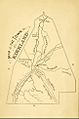
Map of the Town of Kirkland from 1874
-
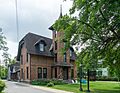
Kirkland town library, in Clinton
-
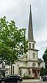
Kirkland Art Center is located in a former Methodist Church built in 1840.


See also
 In Spanish: Kirkland (Nueva York) para niños
