
Otsego County, New York facts for kids
Quick facts for kids
Otsego County
|
|||
|---|---|---|---|

Original Otsego County Bank, in Cooperstown
|
|||
|
|||

Location within the U.S. state of New York
|
|||
 New York's location within the U.S. |
|||
| Country | |||
| State | |||
| Founded | February 16, 1791 | ||
| Seat | Cooperstown | ||
| Largest city | Oneonta | ||
| Area | |||
| • Total | 1,016 sq mi (2,630 km2) | ||
| • Land | 1,002 sq mi (2,600 km2) | ||
| • Water | 14 sq mi (40 km2) 1.4% | ||
| Population
(2020)
|
|||
| • Total | 58,524 | ||
| • Density | 58.4/sq mi (22.5/km2) | ||
| Time zone | UTC−5 (Eastern) | ||
| • Summer (DST) | UTC−4 (EDT) | ||
| Congressional districts | 19th, 21st | ||


Otsego County is a special area called a county in the state of New York. In 2020, about 58,524 people lived here. The main town where the county government is located is Cooperstown. The biggest city in the county is Oneonta.
The name Otsego comes from an old Mohawk or Oneida word. It means "place of the rock." This county is part of the Mohawk Valley area of New York State.
Contents
History of Otsego County
Otsego County has a long and interesting history. It was created a long time ago, even before the United States was fully formed.
How Otsego County Was Formed
Otsego County was one of the first counties created after the American Revolutionary War. It was officially started on February 16, 1791. At that time, it was split off from a much larger area called Montgomery County.
When Otsego County was first formed, it had three main areas called townships:
- Cherry Valley in the northeast.
- Otsego in the northwest.
- Harpersfield in the south.
Governor George Clinton chose the first leaders for Otsego County. These leaders helped set up the county government. For example, William Cooper became the chief judge. He was also the person who founded the town of Cooperstown.
Changes to County Borders
Over the years, Otsego County's shape changed a few times.
- By 1793, the original townships were divided into smaller towns. This made it easier to manage the growing population.
- In 1795, a part of Otsego County was used to help create Schoharie County.
- In 1797, another part of Otsego County was used to help create Delaware County.
- Much later, in 1843, a county in Michigan was named Otsego County, Michigan after this county in New York.
Geography of Otsego County
Otsego County is located in the middle of New York State. It is west of Albany and northeast of Binghamton.
The county covers about 1,016 square miles (2,631 square kilometers). Most of this area is land, with only a small part being water. Otsego County is part of the Central New York Region and the Mohawk Valley Region. It is also considered the northernmost county of the Appalachian Region.
Neighboring Counties
Otsego County shares its borders with several other counties:
- To the north: Herkimer County
- To the northeast: Montgomery County
- To the east: Schoharie County
- To the south: Delaware County
- To the southwest: Chenango County
- To the northwest: Oneida County and Madison County
People and Population
| Historical population | |||
|---|---|---|---|
| Census | Pop. | %± | |
| 1800 | 21,343 | — | |
| 1810 | 38,802 | 81.8% | |
| 1820 | 44,856 | 15.6% | |
| 1830 | 51,372 | 14.5% | |
| 1840 | 49,628 | −3.4% | |
| 1850 | 48,638 | −2.0% | |
| 1860 | 50,157 | 3.1% | |
| 1870 | 48,967 | −2.4% | |
| 1880 | 51,397 | 5.0% | |
| 1890 | 50,861 | −1.0% | |
| 1900 | 48,939 | −3.8% | |
| 1910 | 47,216 | −3.5% | |
| 1920 | 46,200 | −2.2% | |
| 1930 | 46,710 | 1.1% | |
| 1940 | 46,082 | −1.3% | |
| 1950 | 50,763 | 10.2% | |
| 1960 | 51,942 | 2.3% | |
| 1970 | 56,181 | 8.2% | |
| 1980 | 59,075 | 5.2% | |
| 1990 | 60,517 | 2.4% | |
| 2000 | 61,676 | 1.9% | |
| 2010 | 62,259 | 0.9% | |
| 2020 | 58,524 | −6.0% | |
| U.S. Decennial Census 1790-1960 1900-1990 1990-2000 2010-2020 |
|||
In 2020, the population of Otsego County was 58,524 people. The county has a mix of different cultures and backgrounds.
Population Makeup
Here's a look at the different groups of people living in Otsego County, based on the 2020 census:
| Race | Num. | Perc. |
|---|---|---|
| White (not Hispanic) | 51,490 | 88% |
| Black or African American (not Hispanic) | 1,189 | 2.03% |
| Native American (not Hispanic) | 109 | 0.2% |
| Asian (not Hispanic) | 813 | 1.4% |
| Pacific Islander (not Hispanic) | 7 | 0.01% |
| Other/Mixed (not Hispanic) | 2,524 | 4.31% |
| Hispanic or Latino | 2,392 | 4.1% |
Media and Television
Depending on where you are in Otsego County, you might get TV channels from different cities. The northern part of the county is often considered part of the Utica television market. The southern part, including Oneonta, is usually in the Binghamton television market.
Economy and Jobs
The economy in Otsego County is supported by several important industries.
Tourism in Cooperstown
The village of Cooperstown is a big draw for tourists. It is located at the southern end of Otsego Lake. Many people visit to see the Baseball Hall of Fame. There are also museums run by the New York State Historical Association. Another popular attraction is the Glimmerglass Opera, which has summer shows.
Healthcare and Education
Healthcare is a major part of the economy. Bassett Medical Center, which is the main office for Bassett Healthcare Network, is located here. It employs over 3,000 people.
The city of Oneonta is home to two colleges: Hartwick College and the State University of New York at Oneonta. Oneonta also has A.O. Fox Memorial Hospital, which is part of the Bassett Network. The city has many shops and small businesses.
Farming and Rural Life
Overall, Otsego County is still quite rural. Dairy farming is an important industry. Even though the number of farms has changed, dairy production remains steady.
Communities in Otsego County
Otsego County has one city, many towns, and several villages and smaller communities.
City
Towns
Villages
- Cherry Valley
- Cooperstown (This is the county seat)
- Gilbertsville
- Laurens
- Milford
- Morris
- Otego
- Richfield Springs
- Unadilla
Census-Designated Places (CDPs)
- Burlington Flats
- East Worcester
- Edmeston
- Fly Creek
- Garrattsville
- Hartwick
- Hartwick Seminary
- Mount Vision
- Portlandville
- Schenevus
- Schuyler Lake
- South Edmeston
- Springfield Center
- Unadilla Forks
- Wells Bridge
- West End
- Westford
- Worcester
Hamlets
- East Springfield
- Schuyler Lake
- Silver Lake
- West Burlington
- West Edmeston
Images for kids
-
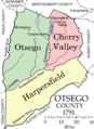
Map of Otsego County when it was first formed in 1791.
-
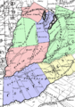
An early map of Otsego County from around 1792-1793.
-
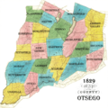
A map of Otsego County from 1829.
-
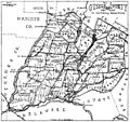
A map of Otsego County from Bacon's History, 1902.


See also
 In Spanish: Condado de Otsego (Nueva York) para niños
