Roseboom, New York facts for kids
Quick facts for kids
Roseboom, New York
|
|
|---|---|

Roseboom, Otsego County, New York
|
|
| Country | United States |
| State | New York |
| County | Otsego |
| Area | |
| • Total | 33.51 sq mi (86.79 km2) |
| • Land | 33.41 sq mi (86.52 km2) |
| • Water | 0.10 sq mi (0.27 km2) |
| Elevation | 1,453 ft (443 m) |
| Population
(2010)
|
|
| • Total | 711 |
| • Estimate
(2016)
|
679 |
| • Density | 20.33/sq mi (7.85/km2) |
| Time zone | UTC-5 (Eastern (EST)) |
| • Summer (DST) | UTC-4 (EDT) |
| ZIP code |
13450
|
| Area code(s) | 607 |
| FIPS code | 36-63638 |
| GNIS feature ID | 0979434 |
Roseboom is a small town in Otsego County, New York, United States. In 2020, about 690 people lived there. This was a slight decrease from 711 people in 2010. The town got its name from early settlers, Abram and John Roseboom.
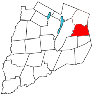
The Town of Roseboom is located on the eastern side of Otsego County.
History of Roseboom
The area that is now Roseboom was not settled until after the American Revolutionary War. This war ended in 1783.
The town of Roseboom was officially created in 1854. It was formed from a part of the nearby Town of Cherry Valley.
Geography of Roseboom
Roseboom covers a total area of about 33.1 square miles (85.7 square kilometers). Most of this area is land, with only a small part being water.
Two important roads, New York State Route 165 and New York State Route 166, meet near the western edge of the town. This meeting point is close to Roseboom village.
The Cherry Valley Creek flows south near the western border of the town. Smaller streams like Pleasant Brook and Snyder Creek flow into it.
People of Roseboom
| Historical population | |||
|---|---|---|---|
| Census | Pop. | %± | |
| 1860 | 1,870 | — | |
| 1870 | 1,589 | −15.0% | |
| 1880 | 1,515 | −4.7% | |
| 1890 | 1,190 | −21.5% | |
| 1900 | 1,031 | −13.4% | |
| 1910 | 885 | −14.2% | |
| 1920 | 773 | −12.7% | |
| 1930 | 633 | −18.1% | |
| 1940 | 534 | −15.6% | |
| 1950 | 570 | 6.7% | |
| 1960 | 518 | −9.1% | |
| 1970 | 483 | −6.8% | |
| 1980 | 630 | 30.4% | |
| 1990 | 668 | 6.0% | |
| 2000 | 684 | 2.4% | |
| 2010 | 711 | 3.9% | |
| 2016 (est.) | 679 | −4.5% | |
| U.S. Decennial Census | |||
In 2000, there were 684 people living in Roseboom. These people made up 267 households and 191 families. The town had about 20.7 people per square mile (8.0 people per square kilometer).
Most of the people living in Roseboom were White (98.39%). A small number were Asian (0.88%), African American (0.15%), or from other backgrounds. About 0.73% of the population identified as Hispanic or Latino.
About one-third of the households (33.3%) had children under 18 living with them. More than half (55.1%) were married couples. The average household had 2.56 people, and the average family had 2.98 people.
The population's age was spread out. About 24.4% were under 18 years old. About 12.7% were 65 years or older. The average age in the town was 39 years.
The average income for a household in Roseboom was $37,841. For families, the average income was $43,438. About 10.6% of all people and 7.4% of families lived below the poverty line. This included 19.4% of those under 18.
Places in Roseboom
Roseboom has several small communities and interesting spots:
- Belvedere Lake – A small lake located to the east of Roseboom village.
- Butlers Corners – A place southwest of South Valley. It is where County Roads 34 and 39 meet.
- Center Valley – A small hamlet in the northeastern part of Roseboom. It is on County Route 50.
- Honey Hill – An elevated area located north of South Valley.
- Pleasant Brook – A stream that flows west past the hamlet of Pleasant Brook.
- Pleasant Brook (hamlet) – A hamlet in the eastern part of Roseboom. It is located on NY-165.
- Roseboom (hamlet) (also known as "Lodi" in the past) – A hamlet near the western town line. It is where NY-165 and NY-166 meet, close to Cherry Valley Creek. The Roseboom Historic District is here. It was added to the National Register of Historic Places in 1998.
- South Valley – A hamlet in the southern part of Roseboom, located on NY-165. The Women's Community Club of South Valley was added to the National Register of Historic Places in 1999.
- Weaver Hill – An elevated area located east of South Valley.
- Weber Corners – A location on the eastern town line, found on NY-165.
- Winnie Hollow – A valley located in the northern part of the town.
See also

- In Spanish: Roseboom para niños
 | Kyle Baker |
 | Joseph Yoakum |
 | Laura Wheeler Waring |
 | Henry Ossawa Tanner |

