
Richfield Springs, New York facts for kids
Quick facts for kids
Richfield Springs, New York
|
|
|---|---|
|
Village
|
|
 |
|
| Nickname(s):
Richfield
|
|

Richfield Springs, New York
Location in New York
|
|
| Country | United States |
| State | New York |
| Region | Central New York; Leatherstocking Region |
| County | Otsego |
| Township | Richfield |
| Area | |
| • Total | 1.01 sq mi (2.61 km2) |
| • Land | 1.01 sq mi (2.61 km2) |
| • Water | 0.00 sq mi (0.00 km2) |
| Elevation | 1,312 ft (400 m) |
| Population
(2020)
|
|
| • Total | 1,050 |
| • Density | 1,042.70/sq mi (402.78/km2) |
| Time zone | UTC-5 (Eastern (EST)) |
| • Summer (DST) | UTC-4 (EDT) |
| ZIP code |
13439
|
| Area code(s) | 315 |
| FIPS code | 36-61489 |
| GNIS feature ID | 0962471 |
| Website | Village of Richfield Springs |
Richfield Springs is a small village in New York, United States. It is located in the Town of Richfield, which is in Otsego County, New York. In 2020, about 1,050 people lived there. The village gets its name from special local sulfur springs that have a unique smell.
Contents
Where is Richfield Springs Located?
Richfield Springs is found at the northern end of Canadarago Lake. It is also right on the border of Herkimer County. The village covers an area of about 1.0 square mile (2.6 square kilometers), and all of it is land.
Several important roads meet in Richfield Springs. These include U.S. Highway 20, New York State Route 28, and New York State Route 167. US 20 and NY 28 briefly share the same path inside the village. NY 167 starts its journey here, connecting with US 20 in the village center.
A Look at Richfield Springs' History
The area where Richfield Springs is now was once known by the Oneida Indians as Ga-no-wan-ges. This name meant "stinking water," likely because of the sulfur springs.
In the past, the village had an electric trolley line called the Southern New York Railroad. This trolley ran from Oneonta to Mohawk. It started serving Richfield Springs in the summer of 1902, making travel easier for people.
Important Buildings and Places
Richfield Springs is home to several places that are important for their history and architecture. These are called historic districts and individual properties.
Historic Districts to Explore
The village has three main historic districts:
- Church Street Historic District
- East Main Street Historic District
- West Main Street-West James Street Historic District
Notable Buildings and Estates
There are also some interesting individual buildings:
- Baker Octagon Barn: This is a unique barn built in an eight-sided shape.
- Richfield Springs Post Office: This building was added to the National Register of Historic Places in 1989 because of its historical importance.
- Clayton Lodge: A famous architect firm designed this large "cottage" for industrialist Cyrus McCormick in 1882. It was a summer home with stables and other buildings. Even the famous landscape designer Frederick Law Olmsted helped plan its gardens. The main house was taken down in 1957, but the stable, though changed, is still there today.
- Sunset Hill: Near Clayton Lodge was the home of Eugene D. Stocker. His estate, called "Sunset Hill," was designed in 1923 and is still standing. It was added to the National Register of Historic Places in 2007.
Who Lives in Richfield Springs?
| Historical population | |||
|---|---|---|---|
| Census | Pop. | %± | |
| 1870 | 696 | — | |
| 1880 | 1,307 | 87.8% | |
| 1890 | 1,623 | 24.2% | |
| 1900 | 1,537 | −5.3% | |
| 1910 | 1,503 | −2.2% | |
| 1920 | 1,388 | −7.7% | |
| 1930 | 1,333 | −4.0% | |
| 1940 | 1,209 | −9.3% | |
| 1950 | 1,534 | 26.9% | |
| 1960 | 1,630 | 6.3% | |
| 1970 | 1,540 | −5.5% | |
| 1980 | 1,561 | 1.4% | |
| 1990 | 1,565 | 0.3% | |
| 2000 | 1,255 | −19.8% | |
| 2010 | 1,264 | 0.7% | |
| 2020 | 1,050 | −16.9% | |
| U.S. Decennial Census | |||
In 2000, there were 1,255 people living in Richfield Springs. About 536 households and 324 families called the village home. The population density was about 1,259 people per square mile.
About 20.7% of the people were under 18 years old. The median age was 45 years. This means half the people were younger than 45 and half were older.
The average income for a household in the village was about $30,170. For families, the average income was around $40,956. About 12.2% of the population lived below the poverty line. This included 16.1% of those under 18.
Famous People from Richfield Springs
Some notable people have connections to Richfield Springs:
- Gaylord Graves: He was a former politician who served in the Wisconsin State Assembly.
- Martha D. Lincoln: She was a writer and journalist.
- Benjamin Pringle: He was a former member of the U.S. Congress.
Images for kids
-
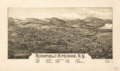
A map of Richfield Springs from 1885, showing different landmarks.
-
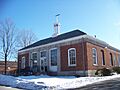
The historic Richfield Springs Post Office building.

See also
 In Spanish: Richfield Springs para niños
