
Canadarago Lake facts for kids
Quick facts for kids Canadarago Lake |
|
|---|---|

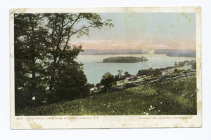
View of Lake from Elm Street Ext, looking south
|
|

Canadarago Lake
Location in New York Adirondack Park

Canadarago Lake
Location in the United States
|
|
| Location | Otsego County, New York |
| Coordinates | 42°48′55″N 75°00′22″W / 42.8152°N 75.0062°W |
| Type | Lake |
| Primary inflows | Ocquionis Creek, Mink Creek, Hyder Creek, Herkimer Creek |
| Primary outflows | Oaks Creek |
| Catchment area | 67.34 sq mi (174.4 km2) |
| Basin countries | United States |
| Max. length | 4.04 mi (6.50 km) |
| Max. width | 1.38 mi (2.22 km) |
| Surface area | 1,917 acres (7.76 km2) |
| Average depth | 24.75 ft (7.54 m) |
| Max. depth | 44 feet (13 m) |
| Water volume | 15,600,000,000 US gal (59,000,000 m3) |
| Shore length1 | 10 miles (16 km) |
| Surface elevation | 1,280 feet (390 m) |
| Islands | 2 Deowongo Island, Loon Island (sunken) |
| Settlements | Richfield Springs, Schuyler Lake |
| 1 Shore length is not a well-defined measure. | |
Canadarago Lake is a beautiful lake in Otsego County, New York. It covers about 1,917-acre (7.76 km2) of water. This lake is where Oaks Creek begins its journey. The town of Richfield Springs sits at the northern end of the lake. Canadarago Lake is the second largest lake in Otsego County. It lies next to the even bigger Otsego Lake. You might also see its name spelled "Candajarago Lake" or "Caniadaraga Lake".
The lake has two islands. One is called Deowongo Island. Its name means "Place of Hearing" in the Oneida Iroquois language. This name came from a cool echo you could hear there. The island became a protected area in 2012 and is now open for everyone to visit. The other island is Loon Island, which is now underwater. It disappeared a long time ago in the early 1800s.
Contents
Exploring Canadarago Lake

Canadarago Lake is a little over four miles (6.4 km) long. Its surface covers 1,917 acres (7.76 km2). The lake is usually about 24.75 feet (7.54 m) deep. At its deepest point, it reaches 44 feet (13 m). The northern part of the lake is in the Town of Richfield. The southern part is in the Town of Otsego. The Town of Exeter borders it on the west.
The lake stretches from the Village of Richfield Springs in the north. It goes all the way to the community of Schuyler Lake in the south. People sometimes called the lake "Schuyler Lake" in the past. The community still uses that name today.
Lake Islands

There is a small island called Deowongo Island near the eastern shore. It's a great spot to visit. There is also a sunken island on Canadarago Lake called Loon Island. This island was less than an acre in size. It was located near the northwest side of the lake, close to Baker's Beach.
Nearby Mountains
You can find some mountains close to the lake. Nine Hill is on the northwest side. King Hill is on the east side. South of King Hill, you'll find Panther Mountain.
Canadarago Lake's Past
In 1778, an event called the Andrustown Massacre happened near Canadarago Lake. This was during the American Revolutionary War. A special marker reminds us of this event. It is located south of Hendersonville on the road to the lake. This road is known as the “Leatherstocking Trail”.
Until the early 1800s, there was a second island on the lake. It was called Loon Island. This island was smaller than Deowongo Island, only about half an acre. Its southern side was marshy. But the northern end, closer to Richfield Springs, had trees and plants. In 1816, a very cold year, the lake's ice broke up early. Strong winds pushed the ice around. This movement scraped away the island's soil and knocked down its trees. Loon Island has been underwater ever since.
In 1872, a small steamboat started sailing on the lake. It was used for fun trips.
The island that remains, Deowongo Island, got its name from the Oneida Indians. They called it "De-O-Won-Go," meaning "Place of Hearing." This was because of a clear echo heard from the island. Daniel Wormer bought the island in 1850. Later, in 2012, the Schoenlein family gave the island to the Otsego Land Trust. This made it open for everyone to enjoy.
In 1902, an electric train line, the Southern New York Railroad, opened. It had two stops along the lake: Canadarago Park and The Lake House. Canadarago Park was on the east shore, about a mile south of The Lake House.
In June 2006, the lake had massive flooding after a lot of rain.
How the Lake Was Formed
Canadarago Lake is similar to the Finger Lakes in New York. Both were carved out by huge sheets of ice called glaciers long ago. However, Canadarago Lake is not considered one of the Finger Lakes. One reason is its higher elevation, about 1,280 feet (390 m). The Finger Lakes are much lower, around 400 feet (120 m). Also, the Finger Lakes flow into Lake Ontario. Canadarago Lake is part of the Susquehanna River watershed.
Canadarago Lake is a "dimictic" lake. This means its waters mix completely twice a year, usually in spring and fall. It is also a "eutrophic" lake, meaning it has many nutrients.
Lake's Water System

Several creeks flow into Canadarago Lake. Ocquionis Creek and Mink Creek enter from the north. Hyder Creek flows in from the west. Herkimer Creek also joins the lake near where Oaks Creek flows out. Oaks Creek then travels south through a marshy area. It flows for about 9 miles (14 km) before joining the Susquehanna River.
The area that drains into Canadarago Lake is called its watershed. This watershed covers about 67 square miles (170 km2). It includes parts of several towns in Otsego County and Herkimer County. Canadarago Lake is at the very beginning of the huge Susquehanna River watershed. This watershed covers 27,510-square-mile (71,300 km2) and reaches all the way to the Chesapeake Bay in Maryland.
Protecting the Lake
Unwanted Guests: Invasive Species
Zebra mussels are tiny creatures that first arrived in the Great Lakes in the 1980s. They came from ships traveling from Europe and Asia. These mussels started living in Canadarago Lake around the year 2000. They can harm native clams by competing for food and space. They also change the lake's food web and can damage docks and swimming areas. Zebra mussels are a big concern in Canadarago Lake because there are many places for them to live.
Keeping the Water Clean
In the past, sewage from Richfield Springs sometimes flowed into Oquionis Creek and then into the lake. This caused too much algae to grow. But in 1973, new cleaning methods were put in place. These methods removed phosphorus from the water. The lake started to get much cleaner within a few years.
Fun at Canadarago Lake
Fishing Adventures
Fishing is one of the most popular activities at Canadarago Lake. Many different kinds of fish live here. Some popular ones include tiger muskie, smallmouth bass, largemouth bass, yellow perch, walleye, and brown trout. You can find many other species too, like alewife, chain pickerel, and common carp.
The lake has a public boat launch on the west side, off State Route 28. This makes it easy for people to get their boats into the water. The New York State Department of Environmental Conservation helps the walleye population. They add about 40,000 young walleyes to the lake each year.
During the summer, there are many bass fishing tournaments. People compete to catch the biggest bass. When winter comes, you can also go ice fishing on the frozen lake.
There are rules for fishing, like how many fish you can catch and when. For Black Bass, the season runs from December 1 to the third Saturday in June. You can catch up to 5 fish per day. The walleye season is from the first Saturday in May to March 15. Since 2017, you must catch walleye that are at least 18 inches (46 cm) long. You can keep up to 3 walleye per day. For Yellow Perch, you can fish all year. The limit is 25 perch per day.
Places to Swim
Baker's Beach is a public picnic area where you can swim. It is open from July 4 through August 30, from 11 AM to 7 PM. Swimming is allowed when a lifeguard is on duty. You can find Baker's Beach on the northwest side of the lake, also accessed by State Route 28.
