Delaware County, New York facts for kids
Quick facts for kids
Delaware County
|
|||
|---|---|---|---|

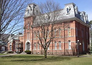
Delaware County Courthouse
|
|||
|
|||

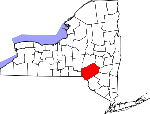
Location within the U.S. state of New York
|
|||
 New York's location within the U.S. |
|||
| Country | |||
| State | |||
| Founded | 1797 | ||
| Named for | Delaware River | ||
| Seat | Delhi | ||
| Largest village | Sidney | ||
| Area | |||
| • Total | 1,467 sq mi (3,800 km2) | ||
| • Land | 1,442 sq mi (3,730 km2) | ||
| • Water | 25 sq mi (60 km2) 1.7% | ||
| Population
(2020)
|
|||
| • Total | 44,308 | ||
| • Density | 30.7/sq mi (11.9/km2) | ||
| Time zone | UTC−5 (Eastern) | ||
| • Summer (DST) | UTC−4 (EDT) | ||
| Congressional district | 19th | ||
Delaware County is a county in the state of New York. In 2020, about 44,308 people lived here. The main town, or county seat, is Delhi. The county gets its name from the Delaware River. This river was named after Thomas West, 3rd Baron De La Warr. He was a governor of Virginia back in 1609. Delaware County is part of the Southern Tier region of New York.
Contents
History of Delaware County
When New York State first created counties in 1683, the land that is now Delaware County was split. It was part of both Albany and Ulster Counties.
Albany County was very large. It covered much of northern New York. It even included land that is now Vermont. Over time, Albany County became smaller. In 1772, it was divided into three parts. One new part was called Tryon County. This county covered the western areas. It was named after William Tryon, who was a British governor.
After the American Revolutionary War ended in 1784, the name Tryon County was changed. It became Montgomery County. This was to honor General Richard Montgomery. He was a hero who fought in the war.
In the late 1780s, New York's governor, De Witt Clinton, gave land to soldiers. Many veterans of the Revolutionary War settled in this area.
Over the years, Montgomery County also became smaller. In 1789, Ontario County was created from it. Then, in 1791, Otsego County was also formed from Montgomery County.
Ulster County was one of New York's first counties. It was very large when Delaware County was created.
Finally, in 1797, Delaware County was officially formed. It was made from parts of Otsego and Ulster counties.
Geography of Delaware County
Delaware County covers about 1,467 square miles (3,799 km²). Most of this is land, with about 25 square miles (65 km²) of water. It is the fifth-largest county in New York by land area.
The county is in the southern part of New York. The Delaware River separates it from Pennsylvania. It is east of Binghamton and southwest of Albany. Part of the beautiful Catskill Mountains are in Delaware County. This area is known as the Southern Tier of New York State.
The highest point is Bearpen Mountain. It is about 3,520 feet (1,073 meters) tall. The lowest point is along the Delaware River. The county has many hills. The soil in the valleys is very rich and good for farming. The Delaware and Susquehanna rivers can be used by boats here.
Neighboring Counties
- Otsego County – to the north
- Schoharie County – to the northeast
- Greene County – to the east
- Ulster County – to the southeast
- Sullivan County – to the south
- Wayne County, Pennsylvania – to the southwest
- Broome County – to the west
- Chenango County – to the northwest
Protected Natural Areas
- Upper Delaware Scenic and Recreational River (part of it is in the county)
People of Delaware County
| Historical population | |||
|---|---|---|---|
| Census | Pop. | %± | |
| 1800 | 10,228 | — | |
| 1810 | 20,303 | 98.5% | |
| 1820 | 26,587 | 31.0% | |
| 1830 | 33,024 | 24.2% | |
| 1840 | 35,396 | 7.2% | |
| 1850 | 39,834 | 12.5% | |
| 1860 | 42,465 | 6.6% | |
| 1870 | 42,972 | 1.2% | |
| 1880 | 42,721 | −0.6% | |
| 1890 | 45,496 | 6.5% | |
| 1900 | 46,413 | 2.0% | |
| 1910 | 45,575 | −1.8% | |
| 1920 | 42,774 | −6.1% | |
| 1930 | 41,163 | −3.8% | |
| 1940 | 40,989 | −0.4% | |
| 1950 | 44,420 | 8.4% | |
| 1960 | 43,540 | −2.0% | |
| 1970 | 44,718 | 2.7% | |
| 1980 | 46,824 | 4.7% | |
| 1990 | 47,225 | 0.9% | |
| 2000 | 48,055 | 1.8% | |
| 2010 | 47,980 | −0.2% | |
| 2020 | 44,308 | −7.7% | |
| U.S. Decennial Census 1790–1960 1900–1990 1990–2000 2010–2020 |
|||
2020 Census Information
In 2020, the census counted the different groups of people living in Delaware County.
| Race | Number of People | Percentage |
|---|---|---|
| White (not Hispanic) | 38,821 | 87.61% |
| Black or African American (not Hispanic) | 1,003 | 2.26% |
| Native American (not Hispanic) | 93 | 0.21% |
| Asian (not Hispanic) | 480 | 1.1% |
| Pacific Islander (not Hispanic) | 7 | 0.01% |
| Other/Mixed (not Hispanic) | 1,919 | 4.33% |
| Hispanic or Latino | 1,985 | 4.5% |
Education in Delaware County
Delaware County is home to the State University of New York at Delhi. This is a college where students can get a higher education.
The DCMO BOCES (Delaware-Chenango-Madison-Otsego; Board of Cooperative Educational Services) also has a campus here. It's called the Robert W. Harrold Campus and is in Sidney Center. BOCES helps provide special programs and services to local schools.
Transportation in Delaware County
Some transportation in Delaware County is provided by Coach USA.
Main Roads

 Future Interstate 86/New York State Route 17 (also known as the Quickway)
 Interstate 88 (also called the Senator Warren M. Anderson Expressway or Susquehanna Expressway)
 New York State Route 8
 New York State Route 10
 New York State Route 23
 New York State Route 28
 New York State Route 30
 New York State Route 97
 New York State Route 206
Communities in Delaware County
Largest Towns and Villages
| # | Location | Population | Type | Area |
|---|---|---|---|---|
| 1 | Sidney | 3,900 | Village | Northwest |
| 2 | Walton | 3,088 | Village | Southwest |
| 3 | †Delhi | 3,087 | Village | Northeast |
| 4 | ‡Deposit | 1,663 | Village | Southwest |
| 5 | Stamford | 1,119 | Village | Northeast |
| 6 | Hancock | 1,031 | Village | Southwest |
| 7 | Downsville | 617 | CDP | Southwest |
| 8 | Margaretville | 596 | Village | Southeast |
| 9 | Hobart | 441 | Village | Northeast |
| 10 | Franklin | 374 | Village | Northwest |
| 11 | Fleischmanns | 351 | Village | Southeast |
| 12 | Davenport Center | 349 | CDP | Northeast |
| 13 | ††Andes | 252 | CDP | Southeast |
| 14 | Bloomville | 213 | CDP | Southwest |
† – This is the County Seat †† – This used to be a Village ‡ – Not completely in this County
Towns in Delaware County
Other Small Communities
- Agloe
- Arkville
- Bedell
- Delancey
- Fraser
- Grand Gorge
- Hawleys
- Halcottsville
- Islamberg
- Roxbury
- South Kortright
See also
 In Spanish: Condado de Delaware (Nueva York) para niños
 | William L. Dawson |
 | W. E. B. Du Bois |
 | Harry Belafonte |


