
Wayne County, Pennsylvania facts for kids
Quick facts for kids
Wayne County
|
|
|---|---|

The Wayne County Courthouse in Honesdale
|
|

Location within the U.S. state of Pennsylvania
|
|
 Pennsylvania's location within the U.S. |
|
| Country | |
| State | |
| Founded | March 21, 1798 |
| Named for | Anthony Wayne |
| Seat | Honesdale |
| Largest borough | Honesdale |
| Area | |
| • Total | 751 sq mi (1,950 km2) |
| • Land | 726 sq mi (1,880 km2) |
| • Water | 25 sq mi (60 km2) 3.3%% |
| Population
(2020)
|
|
| • Total | 51,155 |
| • Density | 70/sq mi (30/km2) |
| Time zone | UTC−5 (Eastern) |
| • Summer (DST) | UTC−4 (EDT) |
| Congressional district | 8th |
Wayne County is a special area called a county in Pennsylvania. It's like a big neighborhood with its own government. In 2020, about 51,155 people lived here. The main town, or county seat, is Honesdale.
Wayne County was created on March 21, 1798. It was named after a brave general from the American Revolutionary War, Anthony Wayne. This county is part of the beautiful Northeast Pennsylvania and Pocono Mountains areas.
The Lehigh River starts in the southern part of Wayne County. This river is about 109 miles (175 km) long. It eventually flows into the Delaware River.
Contents
Exploring Wayne County's Geography
Wayne County covers a total area of 751 square miles (1,945 km²). Most of this, 726 square miles (1,880 km²), is land. The rest, 25 square miles (65 km²), is water.
The land in Wayne County changes a lot. In the wider northern part, the land is rough and hilly near the border with New York State. The southern part has more swampy areas. You'll find higher hills and mountains on the western side of the county. Lower hills are more common in the east, closer to the Delaware River. The middle of Wayne County is a wide, flat area.
The highest point in the county is Mount Ararat. It stands tall at 2,659 feet (810 m). Two other peaks nearby are also very high. The lowest point is about 680 feet (207 m) above sea level. This spot is along the Delaware River, near the border with Pike County, Pennsylvania.
Most of Wayne County's water flows into the Delaware River. This river forms the border between Pennsylvania and New York. However, some small areas in the west drain into the Starrucca Creek or the Lackawanna River. These rivers eventually flow into the Susquehanna River.
Wayne County has a warm-summer humid continental climate. This means it has warm summers and cold winters. In Honesdale, the average temperature is about 22.8°F (-5.1°C) in January. In July, it warms up to about 67.9°F (19.9°C).
Neighboring Counties Around Wayne County
Wayne County shares its borders with several other counties:
- Broome County, New York (to the north)
- Delaware County, New York (to the northeast)
- Sullivan County, New York (to the east)
- Pike County (to the southeast)
- Monroe County (to the south)
- Lackawanna County (to the west)
- Susquehanna County (to the west)
Main Roads in Wayne County
Many important roads help people travel through Wayne County:
 I-84
I-84 I-380
I-380 US 6
US 6 PA 170
 PA 191
 PA 196
 PA 247
 PA 296
 PA 348
 PA 370
 PA 371
 PA 423
 PA 435
 PA 447
 PA 507
 PA 590
 PA 652
 PA 670
 PA 690
People and Population in Wayne County
| Historical population | |||
|---|---|---|---|
| Census | Pop. | %± | |
| 1800 | 2,562 | — | |
| 1810 | 4,125 | 61.0% | |
| 1820 | 4,127 | 0.0% | |
| 1830 | 7,663 | 85.7% | |
| 1840 | 11,848 | 54.6% | |
| 1850 | 21,890 | 84.8% | |
| 1860 | 32,239 | 47.3% | |
| 1870 | 33,188 | 2.9% | |
| 1880 | 33,513 | 1.0% | |
| 1890 | 31,010 | −7.5% | |
| 1900 | 30,171 | −2.7% | |
| 1910 | 29,236 | −3.1% | |
| 1920 | 27,435 | −6.2% | |
| 1930 | 28,420 | 3.6% | |
| 1940 | 29,934 | 5.3% | |
| 1950 | 28,478 | −4.9% | |
| 1960 | 28,237 | −0.8% | |
| 1970 | 29,581 | 4.8% | |
| 1980 | 35,237 | 19.1% | |
| 1990 | 39,944 | 13.4% | |
| 2000 | 47,722 | 19.5% | |
| 2010 | 52,822 | 10.7% | |
| 2020 | 51,155 | −3.2% | |
| U.S. Decennial Census 1790–1960 1900–1990 1990–2000 2010–2017 2010-2020 |
|||
In 2010, there were 52,822 people living in Wayne County. There were 20,625 households, which are groups of people living together. The county had about 72.8 people per square mile (28.1/km²).
Most people in Wayne County were White (94.2%). About 3.1% were African American, and 0.2% were Native American. People of Hispanic or Latino background made up 3.4% of the population.
Many households (67.6%) were families. About 26.6% of households had children under 18 years old. The average household had 2.38 people. The average family had 2.87 people.
The median age of people in Wayne County was 45.9 years. About 21.1% of the population was under 18. About 19.0% was 65 years or older.
In 2013, the average income for a household was $49,313. For families, it was $58,934. About 12.2% of people in the county lived below the poverty line. This included 18.5% of those under 18.
Many people in Wayne County have German (30.3%), Irish (22.1%), or Italian (13.9%) backgrounds.
2020 Census Information
The 2020 census showed these groups in Wayne County:
| Race | Number | Percent |
|---|---|---|
| White (not Hispanic) | 44,821 | 87.62% |
| Black or African American (not Hispanic) | 1,647 | 3.22% |
| Native American (not Hispanic) | 73 | 0.14% |
| Asian (not Hispanic) | 418 | 0.82% |
| Pacific Islander (not Hispanic) | 0 | 0% |
| Other/Mixed (not Hispanic) | 1,849 | 3.61% |
| Hispanic or Latino | 2,347 | 4.6% |
Learning in Wayne County: Schools and Libraries

Wayne County has several options for education.
Public School Districts
Here are the public school districts that serve students in Wayne County:
- Forest City Regional (also in Lackawanna and Susquehanna counties)
- North Pocono (also in Lackawanna County)
- Susquehanna Community (also in Susquehanna County)
- Wallenpaupack Area (also in Pike County)
- Wayne Highlands
- Western Wayne
Private Schools
There are also a few private schools in Wayne County:
- Canaan Christian Academy in Varden
- Saint Dominic's Academy in Honesdale
Libraries for Everyone
The Wayne Library Alliance runs seven public libraries across the county. These libraries are great places to read, learn, and explore!
- The Bethany Public Library in Bethany
- Hamlin Community Library in Hamlin
- The Hawley Public Library in Hawley
- The Newfoundland Area Public Library in Newfoundland
- The Northern Wayne Community Library in Lakewood
- The Pleasant Mount Public Library in Pleasant Mount
- The Wayne County Public Library in Honesdale
Seminaries
There is one seminary in Wayne County, which is a school for religious studies:
- St. Tikhon's Orthodox Theological Seminary in South Canaan.
Communities of Wayne County

In Pennsylvania, there are different types of towns and areas. Wayne County has two main types: boroughs and townships. Townships are classified by the state based on how many people live there. All townships in Wayne County are "second-class" townships.
Here is a list of the main communities in Wayne County:
Boroughs
These are smaller, self-governing towns:
- Bethany
- Hawley
- Honesdale (This is the county seat, the main town for the county government)
- Prompton
- Starrucca (It used to be called Wayne Borough!)
- Waymart
Townships
These are larger areas that include smaller communities:
Census-Designated Places (CDPs)
These are areas that the government counts for population, but they don't have their own local government like boroughs or townships.
- Big Bass Lake (mostly in Lackawanna County)
- Gouldsboro (partially in Monroe County)
- Pocono Springs
- The Hideout
- Wallenpaupack Lake Estates
- White Mills
Other Unincorporated Communities
These are smaller places within townships that don't have their own official boundaries or governments.
Population Ranking of Communities (2010 Census)
This table shows which communities had the most people in 2010:
† county seat
| Rank | City/Town/etc. | Type | Population (2010 Census) |
|---|---|---|---|
| 1 | † Honesdale | Borough | 4,480 |
| 2 | The Hideout | CDP | 3,013 |
| 3 | Waymart | Borough | 1,341 |
| 4 | Wallenpaupack Lake Estates | CDP | 1,279 |
| 5 | Big Bass Lake (mostly in Lackawanna County) | CDP | 1,270 |
| 6 | Hawley | Borough | 1,211 |
| 7 | Pocono Springs | CDP | 926 |
| 8 | Gouldsboro (partially in Monroe County) | CDP | 890 |
| 9 | White Mills | CDP | 659 |
| 10 | Prompton | Borough | 250 |
| 11 | Bethany | Borough | 246 |
| 12 | Starrucca | Borough | 173 |
Images for kids
-
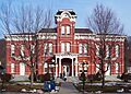
The Wayne County Courthouse in Honesdale
-
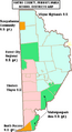
Map of Wayne County's school districts.
-
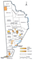
Map of Wayne County with municipalities and CDPs labeled.
See also
 In Spanish: Condado de Wayne (Pensilvania) para niños
