Tanners Falls, Pennsylvania facts for kids
Quick facts for kids
Tanners Falls, Pennsylvania
|
|
|---|---|
| Village of Tanners Falls | |

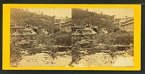
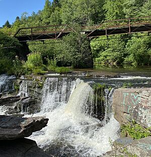
The Tanners' Falls near the confluence of the East and West Branches of the Dyberry Creek, in Tanners Falls.
|
|
| Nickname(s):
Dyberry Falls (historical), Tanner's Falls
|
|
| Country | United States |
| State | Pennsylvania |
| U.S. Congressional District | PA-8 |
| School District | Wayne Highlands Region II |
| County | Wayne |
| Magisterial District | 22-3-04 |
| Township | Dyberry |
| Settled | c. 1830 |
| Founded by | Jason Torrey |
| Named for | Tanners' Falls (water feature) |
| Elevation | 1,043 ft (318 m) |
| Time zone | UTC-5 (Eastern (EST)) |
| • Summer (DST) | UTC-4 (Eastern Daylight (EDT)) |
| ZIP codes | |
| Area code(s) | 570 |
| GNIS feature ID | 1204801 |
| FIPS code | 42-127-20576-76058 |
| Major Roads | |
| Waterways | Camp Cayuga Lake, Dyberry Creek (East and West Branches and union), Lake Cayuga, Long Pond |
Tanners Falls is a small village in Dyberry Township, Wayne County, Pennsylvania, United States. It is located in the Pocono Mountains, a beautiful area known for its lakes and natural scenery.
The village is about six miles from Honesdale, Pennsylvania.
Contents
History of Tanners Falls
Tanners Falls was started around 1830. In the 1850s and 1860s, it was a mostly rural village. It had a post office branch from Honesdale.
Early Industries and Growth
In the early 1850s, a new tannery was built in Tanners Falls by Lewis B. Richtmyer. A tannery is a place where animal hides are turned into leather. This tannery started making leather in 1853. It grew quickly and could process 52,000 hides each year.
Lewis's older brother, Henry Richtmyer, became the first Postmaster when the village opened its own post office in 1856.
During the 1860s, making shoe leather was a major industry in Wayne County. Many tanneries and shoemakers were in the area. Thomas Conroy, who came from Ireland, ran a shoe repair business in Tanners Falls during the 1860s and 1870s.
In 1863, Coe F. Young bought the tannery. He was from New York and had worked with canals and railways before.
The Hilltop Catholic church was built in 1865 for the people of Tanners Falls.
In May 1870, officials in Wayne County started plans to rebuild the bridge in Tanners Falls.
In September 1876, Tanners Falls was one of many towns in danger from wildfires spreading across northwestern Pennsylvania.
Changes in the Late 1800s
Lumber and tannery businesses were active in Tanners Falls during the 1870s and 1880s. However, Coe F. Young's tannery closed in the spring of 1887. This happened because there were no more trees to supply the bark needed for tanning.
Mary W. Alberty became the Postmaster of Tanners Falls in January 1889. The Tanners Falls bridge was repaired later that year.
People also tried to find oil and coal in the area starting in the 1880s. These efforts continued off and on into the early 1900s.
In 1891, Joseph Taylor teamed up with John Reifler & Sons to create a large acid factory in Tanners Falls. Reifler, who came from Germany, had also worked in the tanning industry.
More work was done on the Tanners Falls bridge in 1893.
Telephone service first came to Tanners Falls in the summer of 1896.
More stone work was completed on the Tanners Falls bridge in 1898.
Tanners Falls in the 1900s
On April 27, 1900, the Spring Brook Creamery in Tanners Falls received a new operating permit. In December 1900, a company was hired to build the middle part of the county's iron bridge in Tanners Falls.
In May 1911, the Reifler Acid Company's factory in Tanners Falls was destroyed by a fire. By mid-October, a new factory for making wood alcohol was almost finished.
By the 1920s, the acid company was very important to Tanners Falls. It owned most of the buildings in the village, including many houses. These houses were rented to the company's workers and to people who ran shops and services for them.
However, this changed when the acid company closed permanently on April 8, 1931. After its owners sent their last shipment and let go of their workers, the factory was sold. This sale also included 8,250 acres of forest land and 35 houses that the company owned.
People were worried about how the factory's closing would affect Wayne County. Leaders decided on a plan for the Pennsylvania State Game Commission to buy 7,000 acres of the land. This land included two lakes that were great for fishing. The lakes had smallmouth bass, pickerel, and panfish.
These lands were later opened to the public for fishing and other fun activities. On June 7, 1939, the land officially became "State game lands No. 159." It was one of the largest areas of game land bought for the state's outdoor lovers. Much of the land was heavily wooded and home to deer, rabbits, and ruffed grouse, which is Pennsylvania's state bird. It also had about twelve miles of good trout streams, ponds, and a marsh. The money for this land came from 75 cents of every annual hunting license sold.
The village slowly faded away after the acid factory closed. By the early 1940s, it became a ghost town. To try and save the town, Robert C. Perkins bought the entire village in 1941. Seven years later, Perkins sold the village in an auction. Newspapers described it as a small hamlet that included a "factory, store, houses and stable."
In 1952, Edwin Patrick Kilroe, who was born in Tanners Falls, gave his family's old home and land to a group of priests. They used it to start a seminary. The Kilroe Seminary was dedicated on June 18, 1955, as part of the Roman Catholic Diocese of Scranton.
Roads and Travel
Tanners Falls is centered around the crossing of Upper Woods Road (Pennsylvania Route 4007) and Tanners Falls Road (part of PA-4017).
Several other state routes also go through the village:
- Hancock Highway (part of PA-191)
- Bethany Turnpike (part of PA-670)
- Beech Grove Road (PA-4005)
- Niles Pond Road (PA-4019)
- Egypt Drive
- Egypt Road
All of these main roads are paved.
There are also eight local township roads in Tanners Falls. Six of them are completely within the village:
- Lupyak Road (Township Road 451)
- Bryant Road (T461)
- Pleasant Valley Road (T463)
- Alden Road (T544)
- Haines School Road (T546)
- Kilroe Road (T554)
The other two township roads, Town Hill Road (T437) and Rosehill Road (T467), have parts in other villages. Many of these township roads are unpaved.
Finally, there are fourteen private roads in the community. Most of these are completely within Tanners Falls. All of these private roads are unpaved.
 | Claudette Colvin |
 | Myrlie Evers-Williams |
 | Alberta Odell Jones |


