
Lehigh River facts for kids
Quick facts for kids Lehigh River |
|
|---|---|

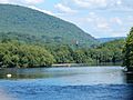
Lehigh River near Jim Thorpe, Pennsylvania
|
|

Lehigh River watershed
|
|
| Country | United States |
| State | Pennsylvania |
| Counties | On the river: Wayne, Lackawanna, Monroe, Luzerne, Carbon, Lehigh, Northampton, Watershed: Wayne, Lackawanna, Monroe, Luzerne, Carbon, Lehigh, Northampton, Schuylkill, Berks, Bucks |
| Cities | Lehighton, Allentown, Bethlehem, Easton |
| Physical characteristics | |
| Main source | Pocono Peak Lake Lehigh Township, Wayne County, Pennsylvania, USA 2,056 ft (627 m) 41°16′42″N 75°24′22″W / 41.27833°N 75.40611°W |
| River mouth | Delaware River Easton, Northampton County, Pennsylvania, USA 160 ft (49 m) 40°41′20″N 75°12′17″W / 40.68889°N 75.20472°W |
| Length | 109 mi (175 km) |
| Discharge (location 2) |
|
| Basin features | |
| Basin size | 1,345 sq mi (3,480 km2) |
| Tributaries |
|
The Lehigh River is a 109-mile long river in eastern Pennsylvania, United States. It flows into the Delaware River. Some parts of the Lehigh River are special. They are called a Pennsylvania Scenic River. This means they are protected for their natural beauty.
The name 'Lehigh' comes from the Lenape people. Their word Lechewuekink means "where there are forks." This describes how the river branches out.
Contents
The Lehigh River's Journey
The Lehigh River winds its way through the Appalachian Mountains. It flows through many valleys between tall ridges.
Where the River Starts
The river begins in the Pocono Mountains of northeastern Pennsylvania. It starts from several ponds in Lehigh Township, Wayne County. This is about 15 miles southeast of Scranton. The main source is Pocono Peak Lake.
How the River Flows
The river first flows southwest through Lackawanna County. It passes through the Francis E. Walter Reservoir. Near White Haven, the river turns south. It then goes through Lehigh Gorge State Park. This part has many exciting whitewater sections.
.jpg)
The river continues to Jim Thorpe. After that, it flows southeast past Lehighton. It then cuts through Blue Mountain at a narrow spot called the Lehigh Gap.
From the Lehigh Gap, the river flows southeast to Allentown. Here, it meets the Little Lehigh Creek. Then it goes northeast past Bethlehem. Finally, the Lehigh River joins the Delaware River in Easton. This spot is right on Pennsylvania's border with New Jersey.
Fish in the Lehigh River
The Lehigh River is home to many different kinds of fish. You can find trout, smallmouth bass, largemouth bass, pickerel, panfish, carp, catfish, Eel, and muskellunge (muskie).
Trout and Bass
Trout, like rainbow and brown trout, often grow to be 18-20 inches long. Some have even been caught in the mid to upper 20-inch range! Smallmouth bass are common but usually smaller, about 8-14 inches. Occasionally, a larger one, 18-21 inches, is caught.
Muskie in the River
More and more muskie are being found in the river. These fish can be very big, from 30 to 52 inches long. Both pure muskie and tiger muskie live here. Tiger muskie are a mix of true muskellunge and northern pike.
Helping Fish Thrive
Since 2005, groups like the Lehigh Coldwater Fishery Alliance have worked with the Army Corps of Engineers. They help manage water releases from the Francis E. Walter Dam. This helps keep the water cold in spring and summer. Colder water helps fish like brown trout grow and reproduce naturally. This is especially true below the dam, all the way to Northampton, PA.
Who Stocks the River
As of November 2019, several groups add trout to the river.
- The Five Mile Club is a private group that stocks trout. They stock from Bear Creek to Glen Onoko.
White Water Fun
The Lehigh River is a great place for white water activities. It has Class I, II, and III rapids. This means some parts are calm, and some are exciting!
Popular Boating Spots
The most popular section for white water rafting, kayaking, and canoeing is in Lehigh Gorge State Park. This park starts at the Francis E. Walter Dam and ends in Jim Thorpe, PA.
Rafting Adventures
Several companies offer guided white water rafting trips. Whitewater Challengers was the first rafting company on the Lehigh River, starting in 1975. Water released from the Francis E. Walter Dam makes sure there's enough water for boating.
Popular Trips
Here are three popular boating trips on the Lehigh River:
- White Haven to Rockport – This trip is 8.7 miles long.
- Rockport to Glen Onoko – This trip is 12.2 miles long.
- White Haven to Glen Onoko – This is the longest trip at 20.9 miles.
Images for kids
-
Lehigh River at Walnutport, August 2015
-

Water tubers in the Lehigh River, June 2020


