
Nesquehoning Creek facts for kids
Quick facts for kids Nesquehoning Creek |
|
|---|---|

Twin sources of Nesquehoning Creek as Nesquehoning Mountain and Broad Mountain merge in the saddle above Tamaqua, Pennsylvania and below the drainage divide from the Little Schuylkill River below and west. (Image is rotated so east is at bottom)
|
|
| Physical characteristics | |
| Main source | Highest of two: on south face Broad Mountain above Hometown 1,360 feet (415 m) 40°51′00″N 75°58′30″W / 40.85°N 75.975°W |
| River mouth | Lehigh River between Jim Thorpe and Nesquehoning, Pennsylvania. 40°52′32″N 75°45′41″W / 40.8755°N 75.7615°W |
| Length | 14.9 mi (24.0 km) |

• Part of the middle Lehigh Valley, Nesquehoning Creek ends near Nesquehoning, flowing from its source between Broad Mountain and Nesquehoning Mountain.
Nesquehoning Creek is a stream in northeastern Pennsylvania, United States. It flows east for about 14.9 miles (24 km) and is a tributary of the Lehigh River.
The creek joins the Lehigh River about 2 miles (3.2 km) upstream from Jim Thorpe, a town in Carbon County.
Contents
What Does "Nesquehoning" Mean?
The name Nesquehoning comes from a Native American language. It is thought to mean "at the black lick," which might refer to a place where animals licked salt.
Where Does Nesquehoning Creek Flow?
Nesquehoning Creek starts on the slopes of Nesquehoning Mountain and Broad Mountain. As it flows, it passes through two man-made lakes. The creek travels through a steep, V-shaped valley. For most of its journey, the stream stays close to Broad Mountain, which adds water to it and makes the valley deeper.
The Nesquehoning Creek area covers about 34 square miles (88 km2). This area is located between Broad Mountain to the northwest and Nesquehoning Mountain to the south. The creek begins where these two mountain ridges meet, in a low area called a saddle near Hometown, Pennsylvania. It ends in the Lehigh River about two miles below the town of Nesquehoning, Pennsylvania, near Mount Pisgah.
From Springs to Lakes
Nesquehoning Creek actually starts from two forested areas, one on the slopes of Broad Mountain and the other on Nesquehoning Ridge. After these two parts join, the creek flows south for about 2 miles (3.2 km). Then, it turns northeast and flows into and through Greenwood Lake, which is almost a mile long.
About 600 feet (183 m) downstream from Greenwood Lake, the creek flows into Lake Hauto. Both Greenwood Lake and Lake Hauto are man-made lakes.
The Journey to the Lehigh River
After Lake Hauto, the creek continues northeast through a narrow valley. This is the steepest part of its journey. Then, the land flattens out, and the creek slows down as it passes through the town of Nesquehoning.
Finally, the stream goes down a narrow section with rapids, where its elevation drops a lot. It then meets the Lehigh River. This meeting point is across from and downstream from the Lehigh River Gorge, which is near Jim Thorpe, Pennsylvania.
Six smaller streams join Nesquehoning Creek from the left side, coming from State Game Lands No. 141. The largest of these are named 'Broad Run' and 'Deep Run'.
How Mountains Shaped the Area
The land around Nesquehoning Creek has steep, heavily forested slopes on Broad and Nesquehoning Mountains. You might also see piles of culm, which are waste materials from coal mining.
Because of the mountains, travel in this area is mostly limited to certain paths. Roads that go north-south are rare and often need to cross through a saddle pass, like where the creek begins. Hometown, a small town high up in the mountains, sits in one of these passes. It's where Pennsylvania Route 54 and Pennsylvania Route 309 meet, and it also has railroad connections.
Transportation and Industry
The Nesquehoning Creek valley has some homes and businesses, including a power plant. However, it has mostly been used as a way for transportation. The Hauto Dam was built near the entrance of the Hauto Railway Tunnel, which was a mile long. This dam helped protect a switching yard for coal trains. These trains served the mines in Lansford and Coaldale, which are on the other side of Nesquehoning Mountain.
Further downstream, within the town of Nesquehoning, there is a small railyard called Nesquehoning Junction. Most of the town of Nesquehoning is on the right bank of the creek, while New Columbus is on the left bank.
Mining's Impact on the Land
Large parts of the valley have been greatly changed by coal mining. Much of the water that runs off from strip mines (where coal is dug from the surface) stays in old mining pits. This means less surface water flows into Nesquehoning Creek. Some smaller streams even join in one of these old mining ponds on Broad Mountain, just above Nesquehoning.
The valley of Nesquehoning Creek has been an important transportation route. Old railroad lines, like those of the Lehigh Valley Railroad and the Central Railroad of New Jersey, and Pennsylvania Route 54 all used this valley. Today, these tracks are used by the Reading Blue Mountain and Northern Railroad and Norfolk Southern. The creek's watershed (the area that drains into it) includes four different towns.
U.S. Route 209 climbs up the steep valley from downtown Nesquehoning. It goes over the ridge to the area where Panther Creek begins. This road crosses the drainage divide on Nesquehoning Mountain.
Part of the creek's water is held in Lake Hauto, which is above the Hauto Dam in the small community of Hauto. This area was important because the Hauto Tunnel helped connect many coal breakers in towns like Lansford, Coaldale, and Summit Hill.
Towns Along the Creek
The Nesquehoning Creek flows through these towns and areas from its start to where it meets the Lehigh River:
- Rush Township, Schuylkill County (starting at 1,129 feet or 344 meters elevation)
- Lehigh Township, Carbon County
- Packer Township, Carbon County
- Nesquehoning borough, Carbon County (the town is about 830 feet or 253 meters above the stream level, and the creek's mouth is two miles further east)
Images for kids
-
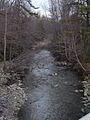
Nesquehoning Creek at the bridge on Industrial Road, Green Acres Industrial Park
-
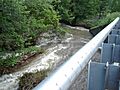
Nesquehoning Creek during the flood of June 27, 2006


