Blue Mountain (Pennsylvania) facts for kids
Quick facts for kids Blue Mountain |
|
|---|---|
Kittatinny Mountain (and nine others:
|
|

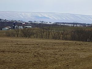
The "Great Wall" of the Blue Mountain in Pennsylvania in February 2008
|
|
| Highest point | |
| Peak | Clarks Knob in Franklin County, Pennsylvania 2,320 feet (710 m) |
| Elevation | 1,129 ft (344 m) |
| Dimensions | |
| Length | 150 mi (240 km) northeast-southwest to SSW 150 miles (240 km) (direct aerial) 255 miles (410 km) trace of ridgeline, including loops back width = varies along chain's length |
| Geography | |
| Country | United States |
| Geology | |
| Orogeny | Appalachian Mountains |
| Age of rock | Silurian |
| Type of rock | Tuscarora Formation and Shawangunk Formation; sedimentary |
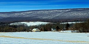
Blue Mountain is a long, narrow mountain ridge in eastern Pennsylvania. It is also known as Blue Mountain Ridge or the Blue Mountains of Pennsylvania. This ridge is part of the larger Appalachian Mountains range.
Blue Mountain forms the southern and eastern edge of the Ridge-and-Valley Appalachians in Pennsylvania. It stretches about 150 miles (240 km) across the state. The mountain starts at the Delaware Water Gap on the New Jersey border in the east. It ends at Big Gap in Franklin County in south-central Pennsylvania.
When you look across most eastern and central Pennsylvania counties, you can often see Blue Mountain. It forms a clear line on the northern or western horizon. Many roads and transportation routes cross this mountain. They usually pass through large natural openings called water gaps. These gaps were carved by rivers like the Susquehanna, Schuylkill, Lehigh, and Delaware River. There are also "wind gaps," which are low spots in the ridge made by ancient rivers.
Blue Mountain acts like a natural border between different parts of Pennsylvania. South of the Susquehanna River, you'll find the Cumberland Valley. This area is part of the Great Appalachian Valley. To the northwest are the southern parts of the Susquehanna Valley. These valleys have streams that lead into the central and western mountains. They also connect to the Coal Region and the Poconos.
South of Blue Mountain, you can find cities like Harrisburg. There is also rich farmland in the Lebanon Valley and the Pennsylvania Dutch Country. The lower parts of the Lehigh Valley and Delaware Valley are also here.
The Blue Mountain School District is named after this mountain range. It is located near Schuylkill Haven, Pennsylvania.
Contents
Mountain Features

Blue Mountain runs for about 150 miles (240 km) through Pennsylvania. Its highest point reaches about 2,270 feet (692 meters) above sea level. This high spot is just north of the Pennsylvania Turnpike, near Newburg. However, most of the mountain ridge is between 1,400 and 1,700 feet (427 to 518 meters) high. The mountain's width changes, usually from 1 to 3 miles (1.6 to 4.8 km) wide.
The southwestern end of the mountain is at Big Gap, west of Shippensburg. From there, the mountain ridge continues southwest into Maryland. The northeastern end of Blue Mountain is at the Delaware Water Gap. This gap is right on the border with New Jersey. A peak called Mount Minsi, which is 1,461 feet (445 meters) high, overlooks the Delaware River here. The ridge then continues northeast into New Jersey as Kittatinny Mountain.
Blue Mountain forms a natural border. It separates the Great Appalachian Valley from the main Ridge-and-Valley Appalachians.
River Gaps Through Blue Mountain
Four of Pennsylvania's biggest rivers have carved paths through Blue Mountain. These paths are called water gaps.
- The Delaware River forms Pennsylvania's eastern border with New Jersey. It cuts through the ridge near Stroudsburg at the Delaware Water Gap.
- The Lehigh River flows into the Delaware River at Easton. It passes through the Lehigh Gap near Palmerton.
- The Schuylkill River flows into the Delaware River at Philadelphia. It goes through the ridge just north of Hamburg.
- The Susquehanna River flows into the Chesapeake Bay. It cuts through the ridge just north of Harrisburg, which is Pennsylvania's capital city.
Pennsylvania Turnpike Tunnels

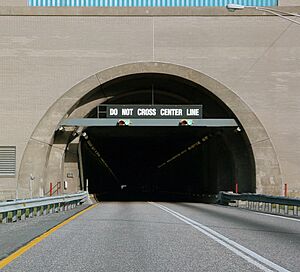
The Pennsylvania Turnpike is a major highway system. It passes through Blue Mountain at two different places using tunnels.
- The Blue Mountain Tunnel carries the main east-west part of the turnpike (Interstate 76). It goes through the ridge in northern Franklin County. Right next to it, the Kittatinny Mountain Tunnel goes through a parallel part of the same mountain. These two tunnel entrances are only about 0.2 miles (0.3 km) apart.
- The Lehigh Tunnel carries the turnpike's north-south Northeast Extension (Interstate 476). It goes through the ridge between Lehigh and Carbon Counties. Both of these tunnels have two tubes, allowing two lanes of traffic to go in each direction.
Fun Places at Blue Mountain
There are several interesting places and attractions located around Blue Mountain in Pennsylvania:
- The Appalachian Trail follows the very top of the ridge. You can hike on it from New Jersey all the way to northern Lebanon County, Pennsylvania.
- Blue Mountain Resort is a ski resort. It is found on the north side of the ridge in southeastern Carbon County, Pennsylvania.
- Boyd Big Tree Preserve Conservation Area is a natural area. It is located in Dauphin County, Pennsylvania.
- Delaware Water Gap National Recreation Area is a large park. It covers parts of Northampton, Monroe, and Pike counties, and also extends into New Jersey.
- Hawk Mountain Ranger School is a training center. It teaches members of the Civil Air Patrol how to do ground search and rescue. It is located just south of the Sanctuary.
- Hawk Mountain Sanctuary is a special place for birds of prey. It is located at the northern edge of Berks County, Pennsylvania.
 | John T. Biggers |
 | Thomas Blackshear |
 | Mark Bradford |
 | Beverly Buchanan |

