
Delaware Water Gap National Recreation Area facts for kids
Quick facts for kids Delaware Water Gap National Recreation Area |
|
|---|---|

Silver Thread Falls, the smaller waterfall at the Dingman's Falls site is located near Dingman's Ferry, Pennsylvania.
|
|

Delaware Water Gap National Recreation Area
Location in New Jersey

Delaware Water Gap National Recreation Area
Location in the United States
|
|
| Location | New Jersey & Pennsylvania, United States |
| Nearest city | Stroudsburg, Pennsylvania, Port Jervis, New York |
| Area | 66,741 acres (270.09 km2) |
| Established | September 1, 1965 |
| Visitors | 4,986,700 (in 2011) |
| Governing body | National Park Service |
| Website | Delaware Water Gap National Recreation Area |
The Delaware Water Gap National Recreation Area is a huge natural park covering about 70,000 acres (28,000 hectares). It stretches along the middle part of the Delaware River in New Jersey and Pennsylvania. This beautiful area goes from the famous Delaware Water Gap all the way north towards Port Jervis, New York, and near Milford, Pennsylvania.
A 40-mile (64 km) part of the Delaware River within this park is super special. It's called the Middle Delaware National Scenic River. This means it's protected for its natural beauty and is also managed by the National Park Service. This river section is at the heart of a historic area once known as the Minisink region.
Contents
What Can You Do Here?
This recreation area covers parts of Sussex and Warren counties in New Jersey. It also includes parts of Monroe, Northampton, and Pike counties in Pennsylvania. The famous Appalachian Trail runs along the eastern side of the park. It's a great place for hiking!
The park is full of interesting places to explore. You can find ancient Native American sites and old buildings from early Dutch settlers. It's like stepping back in time! Even though it feels far away, it's only about an hour's drive from New York City.
There are tons of fun outdoor activities to try. You can go canoeing on the river, hike on many trails, or camp under the stars. Swimming, cycling, and even cross-country skiing in winter are popular. Horseback riding and picnicking are also great options. If you like fishing or hunting, you can do that too, but you'll need a valid state license.
A Look Back in Time
The Minisink Region

The Minisink is an old name for a part of the Upper Delaware River valley. It includes areas in northwestern New Jersey, northeastern Pennsylvania, and even parts of New York.
The name "Minisink" comes from the Munsee people. They were a branch of the Lenape (or Delaware) Native Americans who lived here long ago. The first European settlers arrived in the late 1600s and early 1700s. They were mostly Dutch and French families from New York's Hudson Valley.
Today, we don't use the name "Minisink" as much. But it's important because it reminds us of the early days when Europeans first met Native Americans in this area. Much of this historic Minisink region is now part of the Delaware Water Gap National Recreation Area. This happened after a big plan to build a dam here was stopped.
The Tocks Island Dam Project
The Delaware River sometimes floods, especially after heavy rains or when snow melts. In August 1955, there were huge floods after two hurricanes hit the area. The river rose very high, causing a lot of damage and even some deaths.
Before these floods, there was already a plan to build a dam on the river near a place called Tocks Island. After the 1955 floods, the idea of building a dam became even more serious. The U.S. Army Corps of Engineers suggested building a large dam. This dam would create a huge lake, about 37 miles (60 km) long and up to 140 feet (43 meters) deep.
The area around this new lake was planned to become the Tocks Island National Recreation Area. It would offer activities like hunting, hiking, fishing, and boating. Besides controlling floods, the dam would also create electricity and provide clean water for big cities like New York City and Philadelphia.
Starting in 1960, the government began buying land for this dam project. Many people who lived along the Delaware River had to move from their homes. About 15,000 people were affected. Thousands of homes and other buildings were torn down to prepare for the dam and the lake it would create. This meant losing many old and important historical sites from Native American and colonial times.
Creating the Park
The Delaware Water Gap National Recreation Area was officially approved by Congress in 1965. At first, it was planned to be a smaller area around the proposed dam's reservoir.
However, the dam project faced a lot of problems. Many environmental groups and the people who had to move were strongly against it. Also, the government didn't have enough money for the dam. Scientists also found that the dam would be built near active fault lines, which could be dangerous.
Because of all these issues, the government decided to stop the dam project in 1978. The land that had been bought for the dam was then given to the National Park Service. This land was added to the Delaware Water Gap National Recreation Area, creating the large, beautiful park we have today.
Gallery
-
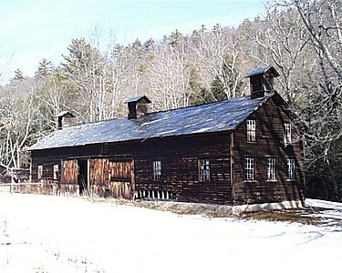
The Hog Barn at the Pennsylvania farm of artist Marie Zimmermann
-
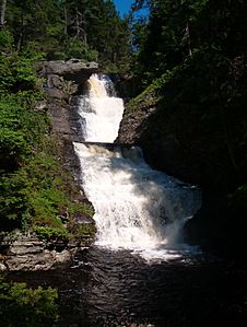
Raymondskill Falls
-
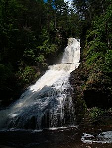
Dingman's Falls
-
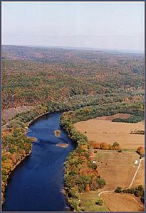
Middle Delaware River above Walpack Bend
-
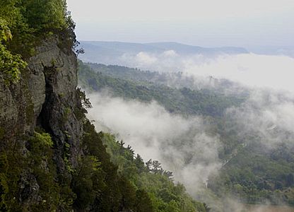
Cliffs above the Delaware River
-
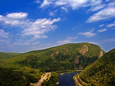
View of Mount Tammany from Delaware Water Gap


Places to See in the Park
- Brau Kettle
- Brodhead Farm
- Callahan House
- Calno School (Old Mine Road-Historical landmark in Hardwick Township, New Jersey)
- Cold Spring Farm Springhouse
- Dingman's Ferry Dutch Reformed Church
- Metz Ice Plant
- John Michael Farm
- Military Trail
- Nyce Farm
- New York - New Jersey Trail Conference
- Schoonover Mountain House
- Capt. Jacob Shoemaker House
- John Turn Farm
- Marie Zimmermann Farm
- Van Campen's Inn
- Raymondskill Falls
- Zion Lutheran Church
- List of waterfalls of the Delaware Water Gap
