
Port Jervis, New York facts for kids
Quick facts for kids
Port Jervis
|
||
|---|---|---|

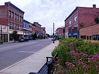
View of Port Jervis, taken from Elks-Brox Park
|
||
|
||
| Motto(s):
Gateway to the Upper Delaware River
|
||
 |
||
| Country | ||
| State | New York | |
| County | Orange | |
| Settled | 1690 | |
| Incorporated (village) | 1853 | |
| Incorporated (city) | 1907 | |
| Named for | John B. Jervis | |
| Government | ||
| • Type | Mayor–council | |
| Area | ||
| • Total | 2.70 sq mi (7.00 km2) | |
| • Land | 2.53 sq mi (6.55 km2) | |
| • Water | 0.17 sq mi (0.44 km2) 6.64% | |
| Elevation | 400 ft (122 m) | |
| Population
(2020)
|
||
| • Total | 8,775 | |
| • Density | 3,468.38/sq mi (1,339.24/km2) | |
| Time zone | UTC−5 (EST) | |
| • Summer (DST) | UTC−4 (EDT) | |
| ZIP Code |
12771
|
|
| Area code | 845 | |
| FIPS code | 36-59388 | |
| GNIS feature ID | 0960971 | |

Port Jervis is a city in Orange County, New York. It is located where the Neversink and Delaware rivers meet. In 2020, about 8,775 people lived there.
Port Jervis is close to other towns like Deerpark and Matamoras, Pennsylvania. Matamoras is just across the river, connected by a bridge. The city is also near the point where three states meet: New York, New Jersey, and Pennsylvania. This spot is called the Tri-States Monument.
Long ago, Port Jervis was important for moving coal. This was done first by canals and then by trains. Today, many people visit Port Jervis for outdoor fun. They enjoy rafting, kayaking, and canoeing in the nearby Delaware Water Gap National Recreation Area.
In 2008, Budget Travel magazine called Port Jervis one of the "Ten Coolest Small Towns."
Contents
History of Port Jervis
Early Settlement and Growth
The first European settlers came to this area around 1690. They were Dutch and English colonists. In 1697, they officially received a land grant for about 1,200 acres. The settlement was first called Mahackamack. This name came from the Lenape people, who lived there before.
During the American Revolutionary War in 1779, British and Mohawk forces attacked Mahackamack. They burned the settlement before the Battle of Minisink. But the people rebuilt their homes over the next 20 years. They also built more roads to connect Mahackamack with other parts of Orange County.
In 1828, the Delaware and Hudson Canal opened. This canal helped transport coal from Pennsylvania to New York. This trade brought money and new growth to the area. On May 11, 1853, the settlement became a village. It was renamed Port Jervis after John B. Jervis, who was the chief engineer of the canal. Port Jervis kept growing and became a city on July 26, 1907.
The Arrival of Railroads
The first train line, the New York & Erie Railroad, came through Port Jervis in 1851. The first passenger train, with President Millard Fillmore on board, arrived on May 14. This railroad later became the Erie Railroad in 1897.
Another railroad, the Port Jervis and Monticello Railroad, opened in 1868. It connected Port Jervis to other cities like Kingston, New York. Just like the canal, the railroads brought new wealth to Port Jervis. They made trade easier and faster.
The railroads eventually replaced the canal, which closed in 1898. Port Jervis became a major hub for the Erie Railroad. By 1922, 20 passenger trains passed through the city every day. More than 2,500 Erie Railroad workers lived there.
After the Great Depression in the 1930s, railroads started to decline. More people began using cars and trucks, especially after World War II. Many railroads struggled financially. In 1957, the New York, Ontario and Western Railway closed down. The Erie Railroad merged with another company in 1960. Later, in 1976, it became part of Conrail, a large railroad company.
Today, Norfolk Southern controls the train tracks around Port Jervis. The decline of the railroads was tough for the city's economy. Port Jervis has been working to find new ways to grow its economy.
Flooding and River History
Port Jervis is located where two rivers meet. This means it can sometimes flood during heavy rains. In 1955, Hurricane Diane caused a big flood. This event even led to a study about how rumors spread during disasters.
Sometimes, ice on the Delaware River can block the water flow. This also causes flooding. In 1875, ice destroyed a bridge to Matamoras, Pennsylvania. In 1981, a large ice jam caused the highest water level ever recorded in the area.
Geography of Port Jervis
Port Jervis is on the north side of the Delaware River. The Neversink River, which is the Delaware's biggest branch, flows into it here. The Mid-Delaware Bridge connects Port Jervis to Matamoras, Pennsylvania, across the Delaware River.
From Port Jervis, the Delaware River flows southwest. It passes by Kittatinny Mountain and the Delaware Water Gap. Then it turns southeast towards Philadelphia and the Delaware Bay.
Port Jervis is also home to the "tri-point." This is the exact spot where the states of New York, Pennsylvania, and New Jersey meet.
The city covers about 2.7 square miles (7.0 square kilometers). Most of this area is land, with a small part being water.
Climate in Port Jervis
Port Jervis has a climate with warm summers and cold winters. It gets about 47 inches (1,198 mm) of rain each year. Most of this rain falls in late spring and early summer. Temperatures have ranged from a very cold -26°F (-32°C) in January 1912 to a very hot 105°F (40.5°C) in July 1936.
| Climate data for Port Jervis, New York 1991–2022 normals, extremes 1893–present | |||||||||||||
|---|---|---|---|---|---|---|---|---|---|---|---|---|---|
| Month | Jan | Feb | Mar | Apr | May | Jun | Jul | Aug | Sep | Oct | Nov | Dec | Year |
| Record high °F (°C) | 71 (22) |
75 (24) |
88 (31) |
96 (36) |
98 (37) |
102 (39) |
105 (41) |
103 (39) |
103 (39) |
93 (34) |
85 (29) |
73 (23) |
105 (41) |
| Mean daily maximum °F (°C) | 33.9 (1.1) |
37.3 (2.9) |
46.2 (7.9) |
60.1 (15.6) |
71.3 (21.8) |
78.8 (26.0) |
83.6 (28.7) |
81.4 (27.4) |
73.8 (23.2) |
61.8 (16.6) |
49.4 (9.7) |
38.5 (3.6) |
59.7 (15.4) |
| Daily mean °F (°C) | 24.9 (−3.9) |
27.1 (−2.7) |
35.4 (1.9) |
47.4 (8.6) |
58.4 (14.7) |
66.9 (19.4) |
71.8 (22.1) |
69.8 (21.0) |
62.4 (16.9) |
50.7 (10.4) |
39.7 (4.3) |
30.4 (−0.9) |
48.7 (9.3) |
| Mean daily minimum °F (°C) | 16.0 (−8.9) |
17.0 (−8.3) |
24.5 (−4.2) |
34.7 (1.5) |
45.6 (7.6) |
55.0 (12.8) |
60.0 (15.6) |
58.3 (14.6) |
51.0 (10.6) |
39.6 (4.2) |
30.1 (−1.1) |
22.8 (−5.1) |
37.8 (3.2) |
| Record low °F (°C) | −26 (−32) |
−20 (−29) |
−9 (−23) |
8 (−13) |
21 (−6) |
34 (1) |
39 (4) |
33 (1) |
21 (−6) |
15 (−9) |
1 (−17) |
−20 (−29) |
−26 (−32) |
| Average precipitation inches (mm) | 3.07 (78) |
2.63 (67) |
3.66 (93) |
3.78 (96) |
3.58 (91) |
4.72 (120) |
4.72 (120) |
4.64 (118) |
4.54 (115) |
4.67 (119) |
3.27 (83) |
3.90 (99) |
47.18 (1,198) |
| Average precipitation days (≥ 0.01 in) | 8.6 | 8.6 | 11.9 | 16.1 | 16.7 | 15.1 | 15.7 | 13.7 | 11.5 | 11.7 | 9.4 | 11.5 | 150.5 |
| Source: NOAA
Weather Atlas |
|||||||||||||
Population and People
| Historical population | |||
|---|---|---|---|
| Census | Pop. | %± | |
| 1870 | 6,377 | — | |
| 1880 | 8,678 | 36.1% | |
| 1890 | 9,327 | 7.5% | |
| 1900 | 9,385 | 0.6% | |
| 1910 | 9,564 | 1.9% | |
| 1920 | 10,171 | 6.3% | |
| 1930 | 10,243 | 0.7% | |
| 1940 | 9,749 | −4.8% | |
| 1950 | 9,372 | −3.9% | |
| 1960 | 9,268 | −1.1% | |
| 1970 | 8,852 | −4.5% | |
| 1980 | 8,699 | −1.7% | |
| 1990 | 9,060 | 4.1% | |
| 2000 | 8,860 | −2.2% | |
| 2010 | 8,828 | −0.4% | |
| 2020 | 8,775 | −0.6% | |
| U.S. Decennial Census | |||
In 2000, there were 8,860 people living in Port Jervis. About 3,533 households were in the city. Many households had children under 18 living with them. The average age of people in the city was 36 years old.
Interesting Places to Visit
State Line Monuments
Port Jervis is very close to where New York, New Jersey, and Pennsylvania meet. You can find two special monuments near Laurel Grove Cemetery. These monuments mark the borders between the three states.
The larger monument is called the "Witness Monument." It's a tall stone pillar. It points to where the New York and Pennsylvania border is in the Delaware River. It also points to the smaller monument.
The smaller monument is called the Tri-States Monument, or Tri-State Rock. This small granite block shows where the borders of all three states come together. Both monuments were put in place in 1882.
Getting Around Port Jervis
Several main roads go through Port Jervis, including US 6 and US 209. Interstate 84 passes just south of the city.
Port Jervis is the last stop on the Port Jervis Line. This is a train service that takes people to and from Hoboken, New Jersey and New York City. The train tracks continue further west, but passenger service stopped in 1966.
You can also take a bus from Port Jervis to places like Honesdale, Pennsylvania and the Port Authority Bus Terminal in New York City.
Schools in Port Jervis
The Port Jervis City School District runs the public schools here.
- Anna S. Kuhl Elementary School is for younger students.
- Port Jervis Middle School is in the city.
- Port Jervis High School is also nearby.
The elementary and high schools are on the same property.
Fun and Recreation
The Port Jervis Recreation department takes care of 13 parks and squares.
- Elks-Brox Park and Riverside Park are the biggest.
- Elks-Brox Park has Skyline Drive and the Elks-Brox Campground. It connects to the Port Jervis Watershed Park, which has over 60 miles of hiking and biking trails.
- Riverside Park has a disc golf course, a pump track for bikes, trails, and playgrounds. It also hosts summer concerts and outdoor movies.
- Farnum Park also has summer concerts, a playground, and a basketball court.
- Basketball courts are at Church Street Park and West End Beach.
- West End Beach is a park along the Delaware River. It has a swimming beach in summer, a boat launch, and places for volleyball and basketball. In winter, it's a popular sledding hill.
- Other parks with playgrounds include Barkley Street Park and John Glenn Park.
The Youth Community Center on Pike Street offers after-school activities all year. They also have summer programs.
The Dog Yard is a free dog park near the Erie Turntable. You need to apply to use it.
The Lynx at River Bend Golf Club is just outside the city.
Local Media
Port Jervis has a radio station, WDLC, which started broadcasting on July 4, 1953. You can also listen to other radio stations like WSPK-FM K104.7 and WRRV on 92.7.
Famous People from Port Jervis
Many notable people have lived in or are from Port Jervis:
- Ed and Lou Banach: Gold medal winners in wrestling at the 1984 Summer Olympics. They went to Port Jervis Senior High School.
- William Stiles Bennet: A U.S. representative for New York.
- Daniel Cohen: A writer of children's books.
- Stephen Crane: A famous author who wrote The Red Badge of Courage. He lived and wrote in Port Jervis for many years.
- Stefanie Dolson: A basketball player for the New York Liberty. She was born in Port Jervis.
- Samuel Fowler: A U.S. representative for New Jersey.
- E. Arthur Gray: The longest-serving mayor of Port Jervis. He later became a New York State Senator.
- Benjamin Hafner: A famous locomotive engineer known as "The Flying Dutchman."
- Albert Hammond Jr.: A musician and producer, best known as a guitarist for The Strokes.
- Bucky Harris: A Baseball Hall of Famer who was born in Port Jervis.
- The Kalin Twins: Hal and Herbie, who had a hit song called "When" in 1958.
- Francis Marvin: A U.S. representative for New York.
- William C. Norris: A major general in the United States Air Force.
- Amar'e Stoudemire: A former professional basketball player for the New York Knicks. He lived in Port Jervis during his school years.
- Hudson Van Etten: A recipient of the Medal of Honor, born in Port Jervis.
Sister City
Port Jervis has a special connection with Lapio, Italy. They are considered "sister cities."
Images for kids
-
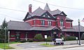
The Erie Depot, built in 1892, was the largest station on the Erie Railroad's Delaware Division. It has been restored and now has shops.
-
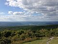
View of Port Jervis from High Point, New Jersey
-
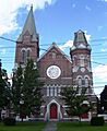
The Deerpark Reformed Church, built in 1838, is the oldest church group in the area.
-
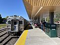
Port Jervis station, where the Metro-North Railroad's Port Jervis Line ends.


Gallery
-
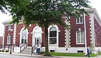
The E. Arthur Gray Post Office, on the NRHP
-
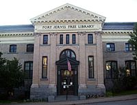
The Free Library, a Carnegie library built in 1903
-
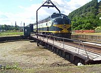
The largest working rail turntable in the U.S. is in Port Jervis
-
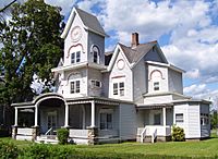
One of the many Victorian style houses in the city
-
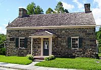
Fort Decker (1793), the oldest building in the city
-
A view of many small businesses on Front St


See also
 In Spanish: Port Jervis para niños
