
Delaware Bay facts for kids
Quick facts for kids Delaware Bay |
|
|---|---|

Delaware Bay in Winter
|
|

Delaware Bay
|
|

Delaware Bay
Location in New Jersey
|
|
| Coordinates | 39°04′N 75°10′W / 39.067°N 75.167°W |
| Type | Bay |
| Surface area | 782 square miles (2,030 km2) |
| Surface elevation | 0 feet (0 m) |
| Official name: Delaware Bay Estuary | |
| Designated: | 20 May 1992 |
| Reference #: | 559 |
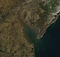
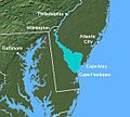
The Delaware Bay is a large body of water where the Delaware River meets the Atlantic Ocean. It's located on the northeast coast of the United States. This bay is about 782 square miles (2,030 km2) in size. Here, fresh water from the river mixes with salty ocean water.
The bay forms the border between the states of New Jersey and Delaware. At the ocean entrance, you'll find the Delaware Capes: Cape Henlopen in Delaware and Cape May in New Jersey. Six counties touch the bay: Sussex, Kent, and New Castle in Delaware, and Cape May, Cumberland, and Salem in New Jersey. You can even cross the bay on the Cape May–Lewes Ferry, which connects Cape May, New Jersey, to Lewes, Delaware.
The edges of the bay are mostly salt marshes and mudflats. These areas are important homes for many animals. Many smaller rivers and streams flow into the bay. These include the Christina River, Smyrna River, and St. Jones River on the Delaware side. On the New Jersey side, rivers like the Salem River and Maurice River add their waters. Many of these river areas are protected because their wetlands are vital breeding grounds for sea creatures. The bay is also famous for its oysters.
The Delaware Bay is a very special place for nature. It was named a Ramsar Wetland of International Importance in 1992. This means it's recognized globally for its important wetlands. It was also the first site chosen for the Western Hemisphere Shorebird Reserve Network. This network helps protect places where shorebirds rest and feed during their long migrations.
Exploring Delaware Bay's Past
When Europeans first arrived in the early 1600s, the Lenape Native American people lived around the bay. They called the Delaware River "Lenape Wihittuck," meaning "the rapid stream of the Lenape." They called the Delaware Bay "Poutaxat," which meant "near the falls."
One of the first Europeans to explore this area was Lucas Vázquez de Ayllón in the 1520s. His captain, Pedro de Quejo, explored the coastline as far north as the Delaware Bay. In 1525, they named it Saint Christopher's Bay.

In the 1600s, the bay was sometimes called "Niew Port May" after Cornelius Jacobsen May. Later, in 1609, Henry Hudson claimed the area for the Dutch East India Company. The Dutch called the bay "Godyns Bay." They even started some settlements, like Zwaanendael Colony, along its shores.

However, in 1638, Peter Minuit helped the Swedish people start their own colony called New Sweden nearby. This led to conflicts with the Dutch. In 1655, Peter Stuyvesant led Dutch forces to take control. But then, in 1667, the English took over the entire New Netherland colony. They renamed the river Delaware after Thomas West, 3rd Baron De La Warr, who was the first Governor of Virginia. The Native American tribe living there also became known as the Delaware. The U.S. state of Delaware also got its name from the bay and river.
The land around the bay was quickly settled. Philadelphia, located upriver, became a very important city in the 1700s. Access to the Delaware Bay was so important that William Penn fought a long legal battle to make sure Pennsylvania had it. During the American Revolutionary War in 1782, a naval battle took place in the bay. Continental Navy Lieutenant Joshua Barney and his small fleet defeated a British squadron.
The Marquis de Lafayette, a French hero of the American Revolution, saw how important the bay was for defense. He suggested building a fort on Pea Patch Island to protect Philadelphia and New Castle, Delaware. This fort, called Fort Delaware, was later built. During the American Civil War, it was used as a prison camp.
Over time, the United States government worked to make the Delaware Bay channel deeper and wider. This helped large ships travel easily from Philadelphia to the ocean.
Delaware Bay Today
Today, the Delaware Bay is one of the busiest waterways in the United States. It's second only to the Mississippi River in terms of ship traffic. The lower part of the bay is also part of the Intracoastal Waterway, a network of canals and channels that allows boats to travel along the coast.
To make travel easier, there are canals that connect the bay to the ocean and other waterways. The Cape May Canal and the Lewes and Rehoboth Canal help boats avoid going around the capes. The upper bay is also connected to the Chesapeake Bay by the Chesapeake and Delaware Canal.

Navigating the bay can be tricky for sailors. The currents can be strong, and the water is often shallow outside the main shipping channel. There are also not many places to find shelter from storms.
The Delaware Bay is incredibly important for wildlife. It's a key resting spot for over 30 types of migrating shorebirds. These birds stop here in May to refuel on horseshoe crab eggs after their long journey north. The Delaware Bay has the largest population of horseshoe crabs in the world, making it a vital ecosystem for these amazing creatures and the birds that depend on them.
Images for kids
-
Delaware Bay in Winter
-
Delaware Bay
See also
 In Spanish: Bahía de Delaware para niños
