Salem River facts for kids
Quick facts for kids Salem River |
|
|---|---|

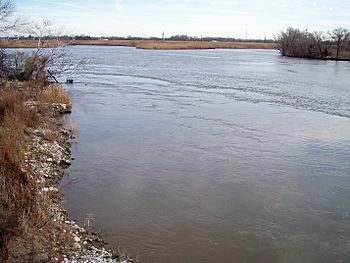
The Salem River in Salem in 2006
|
|
| Country | United States |
| State | New Jersey |
| City | Salem |
| Physical characteristics | |
| Main source | Upper Pittsgrove Township 39°35′59″N 75°13′45″W / 39.59972°N 75.22917°W |
| River mouth | Delaware River boundary of Pennsville and Elsinboro townships 0 ft (0 m) 39°34′23″N 75°30′44″W / 39.57306°N 75.51222°W |
| Length | 35 mi (56 km) |
| Basin features | |
| Basin size | 110 sq mi (280 km2)plus |
The Salem River is a river in southwestern New Jersey, United States. It is about 35 miles (56 km) long. The river flows into the Delaware River.
Contents
Where the Salem River Flows
The Salem River is completely within Salem County. It starts in Upper Pittsgrove Township. The river then flows west through Pilesgrove Township. It also passes through the town of Woodstown.
River's Journey
The river continues along the edges of Carneys Point and Mannington Townships. Near a place called Deepwater, the Salem River gets very close to the Delaware River. There's even a canal, the Salem (Deepwater) Canal, that connects the two rivers.
After this, the Salem River turns south. It flows along the border of Mannington and Pennsville Townships. Here, the river gets wider and forms a shallow, winding area called Kates Creek Meadow.
Reaching the Delaware River
The river then passes the city of Salem. This is as far as large boats can travel up the river. Finally, the Salem River flows into the Delaware River. This happens near the start of Delaware Bay. The meeting point is between Pennsville and Elsinboro townships. It's about 2 miles (3 km) west of Salem city.
How Boats Use the River
Both the Delaware River and the Salem River are affected by tides. This means their water levels go up and down with the ocean tides. The main shipping path in the Delaware River is kept very deep. This allows large ships to use it.
Salem River's Shipping Path
The shipping path in the Salem River is much shallower. This means only smaller boats can use the Port of Salem. Ships enter the Salem River through Salem Cove. This cove is about 50 miles (80 km) from the entrance of the Delaware Bay. The channel goes along the southeast side of the cove for 2 miles (3 km). It then continues another 3 miles (5 km) upstream past the first bridge.
River Improvements
The Salem River and its "Cut-Off" section were made deeper in 1925. This was done to help boats travel more easily.
History of the Salem River
The Salem River has had a few different names over time. It was once known as Firkins Creek, Varkens Kill, and Varkins Kill. The name "Varkens Kill" means "Hogg Creek." In 1940, the United States Board on Geographic Names officially decided on "Salem River."
Early Settlements
Long ago, the Lenape people lived near the river's mouth. In 1641, people from the New Haven Colony settled along the Varkens Kill. A Swedish settlement called Fort Elfsborg was built near the mouth of the Salem River. This happened in 1642–1643.
The fort was later left empty. This was because of many mosquitoes. Also, the Dutch built a new fort, Fort Casimir, across the river. In 1675, the village of Salem was started near the mouth of the Salem River. This was part of the Fenwick Colony.
 | James Van Der Zee |
 | Alma Thomas |
 | Ellis Wilson |
 | Margaret Taylor-Burroughs |

