Pilesgrove Township, New Jersey facts for kids
Quick facts for kids
Pilesgrove Township, New Jersey
|
||
|---|---|---|
|
Township
|
||
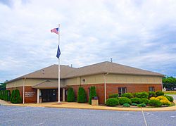
Municipal Building
|
||
|
||
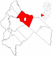
Pilesgrove Township highlighted in Salem County. Inset map: Salem County highlighted in the State of New Jersey.
|
||
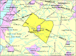
Census Bureau map of Pilesgrove Township, New Jersey
|
||
| Country | ||
| State | ||
| County | ||
| Earliest mention | April 15, 1701 | |
| Incorporated | February 21, 1798 | |
| Government | ||
| • Type | Township | |
| • Body | Township Committee | |
| Area | ||
| • Total | 35.17 sq mi (91.09 km2) | |
| • Land | 34.94 sq mi (90.48 km2) | |
| • Water | 0.23 sq mi (0.61 km2) 0.67% | |
| Area rank | 69th of 565 in state 5th of 15 in county |
|
| Elevation | 62 ft (19 m) | |
| Population
(2020)
|
||
| • Total | 4,183 | |
| • Estimate
(2023)
|
4,224 | |
| • Rank | 409th of 565 in state 6th of 15 in county |
|
| • Density | 119.7/sq mi (46.2/km2) | |
| • Density rank | 532nd of 565 in state 8th of 15 in county |
|
| Time zone | UTC−05:00 (Eastern (EST)) | |
| • Summer (DST) | UTC−04:00 (Eastern (EDT)) | |
| ZIP Code |
08098
|
|
| Area code(s) | 856 exchange: 769 | |
| FIPS code | 3403358530 | |
| GNIS feature ID | 0882132 | |
| Website | ||
Pilesgrove Township is a community located in Salem County, New Jersey. It is known for its rural areas and farming. In 2020, about 4,183 people lived here. This was a small increase from the 4,016 people counted in 2010.
Contents
History of Pilesgrove Township
Pilesgrove was first mentioned in a document on April 15, 1701. It became one of New Jersey's first 104 townships on February 21, 1798. This means it officially became a town with its own local government. The township was named after a person named Thomas Pyle. Over time, parts of Pilesgrove were used to create other towns. For example, Pittsgrove Township was formed in 1769. Later, Woodstown was created in 1882.
Protecting Farms: The Right-to-Farm Law
In 1979, Pilesgrove Township made history. It passed New Jersey's first "right-to-farm" law. This special law helps protect farms and farming activities. It says that farming is a "natural right" and is allowed everywhere in the township. This helps ensure that farming can continue to thrive in the area.
Geography and Landscape
Pilesgrove Township covers about 35.17 square miles (91.09 square kilometers). Most of this area is land. A small part, about 0.23 square miles (0.61 square kilometers), is water. The Salem River flows through the township.
Neighboring Towns and the "Doughnut" Effect
Pilesgrove Township shares borders with several other towns in Salem County. These include Alloway Township, Carneys Point Township, Mannington Township, Oldmans Township, and Upper Pittsgrove Township. It also borders Gloucester County.
Interestingly, the town of Woodstown is completely surrounded by Pilesgrove Township. This is like a "doughnut" shape, where one town is the hole in the middle of another. Woodstown is a busier area with more shops. Pilesgrove, on the other hand, is mostly farmland.
Local Communities and Solar Power
Within Pilesgrove Township, there are several smaller communities. These include Avis Mills, Friendship, Sharptown, and Yorktown. A place called Auburn is also partly in Pilesgrove.
Pilesgrove is home to a very large solar farm. The Pilesgrove Solar Farm covers 100 acres (about 40 hectares). It has 71,000 solar panels. These panels create 20 megawatts of electricity. This is enough power for more than 5,000 homes!
Population and People
| Historical population | |||
|---|---|---|---|
| Census | Pop. | %± | |
| 1810 | 1,756 | — | |
| 1820 | 2,012 | 14.6% | |
| 1830 | 2,150 | 6.9% | |
| 1840 | 2,477 | 15.2% | |
| 1850 | 2,962 | 19.6% | |
| 1860 | 3,359 | 13.4% | |
| 1870 | 3,385 | 0.8% | |
| 1880 | 3,007 | −11.2% | |
| 1890 | 1,796 | * | −40.3% |
| 1900 | 1,744 | −2.9% | |
| 1910 | 1,606 | −7.9% | |
| 1920 | 1,770 | 10.2% | |
| 1930 | 1,815 | 2.5% | |
| 1940 | 1,614 | −11.1% | |
| 1950 | 1,942 | 20.3% | |
| 1960 | 2,519 | 29.7% | |
| 1970 | 2,706 | 7.4% | |
| 1980 | 2,810 | 3.8% | |
| 1990 | 3,250 | 15.7% | |
| 2000 | 3,923 | 20.7% | |
| 2010 | 4,016 | 2.4% | |
| 2020 | 4,183 | 4.2% | |
| 2023 (est.) | 4,224 | 5.2% | |
| Population sources: 1810–2000 1810–1920 1840 1850–1870 1850 1870 1880–1890 1890–1910 1910–1930 1940–2000 2000 2010 2020 * = Lost territory in previous decade. |
|||
In 2010, Pilesgrove Township had 4,016 people living there. There were 1,488 households. Most households (63.9%) were married couples. About 27.5% of households had children under 18. The average household had 2.62 people.
The population was diverse. About 90.81% of residents were White. About 5.93% were Black or African American. Around 0.92% were Asian. People of Hispanic or Latino background made up 2.59% of the population.
The median age in Pilesgrove was 47.3 years old. About 20.4% of the people were under 18. About 21.0% were 65 years or older.
Culture and Fun Activities
Pilesgrove Township is home to a unique cultural spot: Cowtown Rodeo. This is the only professional weekly rodeo in New Jersey. It is also one of the oldest weekly professional rodeos in the entire United States. The rodeo season usually runs from late May to late September. It's a great place to see cowboys and cowgirls in action!
Education for Kids
Students in Pilesgrove Township go to public schools in the Woodstown-Pilesgrove Regional School District. This district serves students from pre-kindergarten all the way through twelfth grade. The district has four schools:
- William Roper Early Childhood Learning Center (PreK-K)
- Mary S. Shoemaker Elementary School (grades 1-5)
- Woodstown Middle School (grades 6-8)
- Woodstown High School (grades 9-12)
Some students from nearby towns also attend Woodstown High School. These towns include Alloway Township, Oldmans Township, and Upper Pittsgrove Township.
Getting Around: Transportation
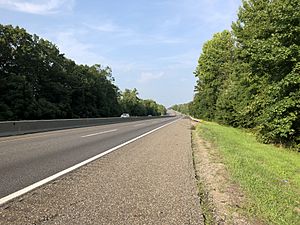
Pilesgrove Township has many roads for getting around. As of 2010, there were over 85 miles of roadways. Some roads are maintained by the township, some by Salem County, and some by the state of New Jersey.
Major Roads and Highways
The New Jersey Turnpike passes through the northwest part of Pilesgrove Township. This is a major highway for traveling across the state. U.S. Route 40 goes through the township from east to west. Route 45 crosses from south to north. These two main roads meet in Woodstown, the town surrounded by Pilesgrove.
Public Transport Options
NJ Transit offers bus service for residents. You can take the 401 bus route between Salem and Philadelphia. There is also a freight rail line, the Salem Branch, that runs through the township. This line is used to transport goods by train.
Local Wineries
Pilesgrove Township is home to a few wineries where grapes are grown and wine is made.
Notable People from Pilesgrove
Many interesting people have lived in or are connected to Pilesgrove Township.
- Jim Cook Jr. (born 1987), a former journalist.
- Nathan Dunn (1782–1844), a businessman and generous giver.
- Nathan T. Stratton (1813–1887), who served in the United States House of Representatives for New Jersey from 1851 to 1855.
See also
 In Spanish: Municipio de Pilesgrove para niños
 | Laphonza Butler |
 | Daisy Bates |
 | Elizabeth Piper Ensley |


