Auburn, New Jersey facts for kids
Quick facts for kids
Auburn, New Jersey
|
|
|---|---|
| Country | |
| State | |
| County | Salem |
| Townships | Oldmans Pilesgrove |
| Area | |
| • Total | 4.30 sq mi (11.13 km2) |
| • Land | 4.25 sq mi (11.01 km2) |
| • Water | 0.04 sq mi (0.12 km2) |
| Elevation | 77 ft (23 m) |
| Population
(2020)
|
1,057 |
| Time zone | UTC−05:00 (Eastern (EST)) |
| • Summer (DST) | UTC−04:00 (EDT) |
| ZIP Codes | |
| Area code(s) | 856 |
| FIPS code | 34-02170 |
| GNIS feature ID | 2806229 |
Auburn is a small community in Salem County, New Jersey. It is known as a census-designated place (CDP). This means the U.S. Census Bureau sets its borders to count people, even though it doesn't have its own local government like a city or town.
Auburn is part of two larger areas: Oldmans Township and Pilesgrove Township. It includes both quiet rural areas and some suburban parts.
Where is Auburn?
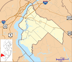
Auburn is located in the northern part of Salem County. To its northeast, you'll find Oldmans Creek. This creek forms a natural border, separating Auburn from Woolwich Township in Gloucester County.
The New Jersey Turnpike, a major highway, runs through the northern section of Auburn. If you need to get on the turnpike, the closest exits are about 7 miles southwest near the Delaware Memorial Bridge or 6 miles northeast near Swedesboro.
Population of Auburn
Auburn was first officially recognized as a CDP before the 2020 census. During the 2020 census, the population of Auburn was counted as 1,057 people.
 | Madam C. J. Walker |
 | Janet Emerson Bashen |
 | Annie Turnbo Malone |
 | Maggie L. Walker |


