
New Jersey Turnpike facts for kids
Quick facts for kids
|
||||||||||
|---|---|---|---|---|---|---|---|---|---|---|
| Lua error in Module:Infobox_road/map at line 15: attempt to index field 'wikibase' (a nil value). | ||||||||||
| Route information | ||||||||||
| Maintained by the New Jersey Turnpike Authority | ||||||||||
| Length | 122.40 mi (196.98 km)
11.03 mi (17.75 km) – Western Spur
6.55 mi (10.54 km) – Pennsylvania Extension 8.17 mi (13.1 km) – Newark Bay Extension |
|||||||||
| Existed | 1951–present | |||||||||
| Major junctions | ||||||||||
| South end | ||||||||||
| North end | ||||||||||
| Highway system | ||||||||||
| New Jersey State Highway Routes Interstate and US
|
||||||||||

The New Jersey Turnpike is a very important road in New Jersey. It's a special kind of road called a toll road, which means you pay a small fee to drive on it. This money helps keep the road in good condition. The Turnpike stretches from the southern part of New Jersey, near the Delaware Memorial Bridge, all the way up to the northern part, close to New York City and the George Washington Bridge.
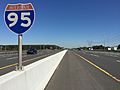
The northern section of the New Jersey Turnpike is also part of Interstate 95, a major highway that runs along the East Coast of the United States. The New Jersey Turnpike is one of the busiest toll roads in the entire country, with millions of cars using it every year. It helps people travel quickly across the state for work, school, or vacations.
Contents
What is the New Jersey Turnpike?
The New Jersey Turnpike is a long highway that runs for about 122 miles (196 kilometers) through New Jersey. It was built to make travel faster and easier across the state. Because it's a toll road, drivers pay a fee, usually when they enter or exit the highway. This system helps fund the road's upkeep and improvements.
Why is it a Toll Road?
Toll roads are special because they charge drivers a fee to use them. This money is then used to pay for building the road, keeping it in good shape, and making sure it's safe. The New Jersey Turnpike Authority is the group in charge of managing the Turnpike. They use the tolls to maintain the road, fix potholes, and even expand it when needed.
When was the Turnpike Built?
The New Jersey Turnpike first opened in 1951. It was a big project that helped connect different parts of the state and made it much easier to travel between major cities like Philadelphia and New York City. Over the years, parts of the Turnpike have been expanded and improved to handle more traffic.
Where Does the Turnpike Go?
The New Jersey Turnpike starts in the southern part of the state, near Pennsville Township, where it connects with other major roads like Interstate 295 and U.S. Route 40. It then travels northeast, passing through many different counties and towns.
Connecting Major Areas
As it goes north, the Turnpike connects to many other important highways. These connections allow drivers to easily reach places like Trenton, Newark, and Jersey City. It also links up with roads that lead to the Jersey Shore and other popular destinations.
The Turnpike has several different sections, including:
- The Western Spur: This is a section that splits off and then rejoins the main Turnpike.
- The Pennsylvania Extension: This part connects to the Pennsylvania Turnpike, making it easy to travel between New Jersey and Pennsylvania.
- The Newark Bay Extension: This section provides a route to areas around Newark Bay, including Newark Liberty International Airport.
The Turnpike ends in the northern part of New Jersey, in Fort Lee, very close to the George Washington Bridge, which crosses into New York City.
Traveling on the Turnpike
Driving on the New Jersey Turnpike is usually a smooth experience because it's a well-maintained highway. There are many lanes, especially in the busier northern sections, to help traffic flow.
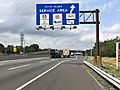
Service Areas
Along the Turnpike, there are special places called service areas. These are like rest stops where drivers can pull off the road to get gas, food, and use restrooms. Some service areas are named after famous New Jersey people or historical figures, like the Molly Pitcher Service Area or the Joyce Kilmer Service Area. They are very helpful for long trips!
Toll Collection
When you enter the Turnpike, you might get a ticket that shows where you got on. When you exit, you give the ticket to a toll collector, and they tell you how much you owe based on how far you traveled. Many drivers also use electronic toll collection systems, like E-ZPass, which let them pay tolls automatically without stopping.
Images for kids
-
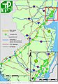
Detailed map of the New Jersey Turnpike including interchange locations and other surface highways in New Jersey
-
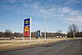
Signage at the southern end of the turnpike on I-295/US 40 in Pennsville Township
-
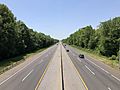
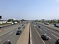
View south along the New Jersey Turnpike in East Greenwich Township
-
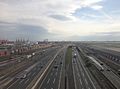
View south along the turnpike from a plane landing at Newark Liberty International Airport
-
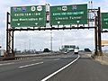
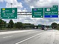
New Jersey Turnpike (I-95) northbound approaching split into Western Spur and Eastern Spur in Newark
-
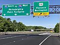
View south along the Pearl Harbor Memorial Turnpike Extension (I-95) at US 130 in Florence
-
I-95 southbound at the north end of New Jersey Turnpike Authority jurisdiction in Fort Lee
-
Molly Pitcher Service Area
-
John Fenwick Service Area
-
Signage for the Joyce Kilmer Service Area
-
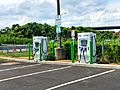
Electric Vehicle charging machines at Vince Lombardi Service Area
-
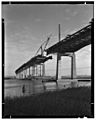
Hackensack Run bridge under construction in 1951
-
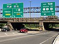
New Jersey Turnpike (I-95) northbound in Linden
-
New Jersey Turnpike (I-95) southbound at the Route 33/Route 133 interchange in East Windsor Township
-
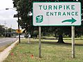
Typical sign at non-freeway entrances to the turnpike; this one is located at exit 3
-
View north along the New Jersey Turnpike in Hamilton Township, Mercer County. This was one of the southernmost I-95 signs on the mainline turnpike before the completion of I-95 in September 2018.
-
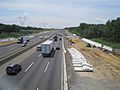
Construction of the new lanes as seen in Robbinsville Township in July 2012
-
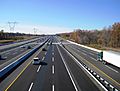
Completed 12-lane roadway from same point as above in November 2014
-
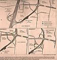
Three proposals for new exit 8 in East Windsor. Alternative 1 was chosen (with a few changes)
-
An older variable-message sign displaying a warning. These signs have since been replaced.
-
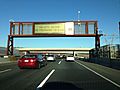
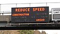
A newer variable-message sign displaying a warning about congestion ahead
-
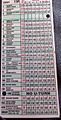
A toll ticket received at exit 15W in 2008
-
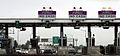
A New Jersey Turnpike tollgate for exit 8A in Monroe Township

_in_Pennsville_Township,_Salem_County,_New_Jersey.jpg)
_from_the_overpass_for_Gloucester_County_Route_673_(Cedar_Road)_in_East_Greenwich_Township,_Gloucester_County,_New_Jersey.jpg)

_the_split_between_the_New_Jersey_Turnpike_Eastern_Spur_and_New_Jersey_Turnpike_Western_Spur_in_Newark,_Essex_County,_New_Jersey.jpg)
_at_the_exit_for_U.S._Route_130_(Florence,_Burlington)_in_Florence_Township,_Burlington_County,_New_Jersey.jpg)
_at_Exit_72B_(U.S._Route_1_and_U.S._Route_9_SOUTH_TO_U.S._Route_46,_Palisades_Park)_in_Fort_Lee,_New_Jersey.jpg)


_at_the_Joyce_Kilmer_Service_Area_in_East_Brunswick_Township,_Middlesex_County,_New_Jersey.jpg)


_from_the_overpass_for_Union_County_Route_617_(Tremley_Point_Road)_in_Linden,_Union_County,_New_Jersey.jpg)
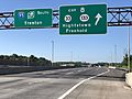
_at_Exit_8_(New_Jersey_State_Route_33,_New_Jersey_State_Route_133,_Hightstown,_Freehold)_in_East_Windsor_Township,_Mercer_County,_New_Jersey.jpg)
_at_the_exit_for_the_New_Jersey_Turnpike_in_Bellmawr,_Camden_County,_New_Jersey.jpg)
_just_south_of_Exit_7A_(Interstate_195,_Trenton,_Shore_Points)_in_Hamilton_Township,_Mercer_County,_New_Jersey.jpg)


_IC_8_options.jpg)

_just_north_of_Exit_7A_(Interstate_195,_Trenton,_Shore_Points)_in_Robbinsville_Township,_Mercer_County,_New_Jersey.jpg)


See also
 In Spanish: New Jersey Turnpike para niños
