Newark Bay facts for kids
Quick facts for kids Newark Bay |
|
|---|---|
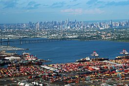
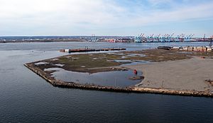
Port Newark is seen in the foreground looking northeast across the bay to Jersey City and the Manhattan borough of New York City.
|
|
| Location | New Jersey |
| Coordinates | 40°40′47″N 74°07′53″W / 40.679597°N 74.131451°W |
| Type | Bay |
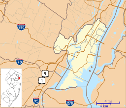
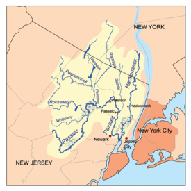
Newark Bay is a large bay in northeastern New Jersey. It's where the Passaic River and Hackensack River meet. This bay is a very busy place! It's home to the Port Newark-Elizabeth Marine Terminal. This port is the biggest place for container shipping in the Port of New York and New Jersey. It's also the second busiest in the entire United States.
Newark Bay is an estuary, which means it's where fresh river water mixes with salty ocean water. To keep it deep enough for large ships, parts of the bay are often dug out (this is called dredging).
Contents
Geography of Newark Bay
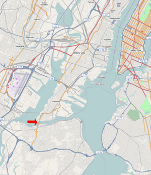
Newark Bay has a rectangular shape. It is about 5.5 miles (8.8 km) long. Its width changes from 0.6 to 1.2 miles (1 to 1.9 km). On its western side are the cities of Newark and Elizabeth. On the eastern side, you'll find Jersey City and Bayonne.
To the south is Staten Island, New York. To the north, Kearny Point and Droyer's Point mark where the Hackensack River flows in. There's also a small island called Shooters Island. It's a special place for birds and sits where Staten Island, Bayonne, and Elizabeth meet.
The Atlantic Ocean is about 11 miles (18 km) away. Ships reach the ocean through deep channels that are kept open by dredging. Newark Bay connects to Upper New York Bay through a channel called the Kill Van Kull. It also connects to Raritan Bay through the Arthur Kill. These names come from the time when the Dutch explored and settled this area. "Kill" means "stream" or "channel" in Dutch.
Bridges Crossing the Bay
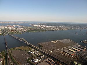
Several bridges cross Newark Bay. The Vincent R. Casciano Memorial Bridge carries a part of the New Jersey Turnpike. This road is called Interstate 78.
North of the Casciano Bridge is the Upper Bay Bridge. This bridge can be lifted to let tall ships pass underneath. It is used by CSX Transportation to carry freight, like the famous "Juice Train." There was once another bridge, the CRRNJ Newark Bay Bridge, built in 1864. It was taken down in the 1980s because it was a danger to ships.
Along the Shoreline
Elizabethport to the Ironbound
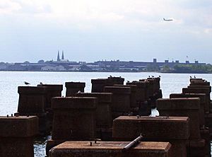
Elizabeth was one of the first English settlements in New Jersey. Its port was very important a long time ago. Today, you can find Jersey Gardens, a large shopping mall, near the bay in Elizabeth.
The western side of Newark Bay used to be mostly shallow wetlands. In the 1910s, the city of Newark started digging a shipping channel. This channel became the start of Port Newark. During World War I, the port grew quickly. Many troops were stationed at the Newark Bay Shipyard.
After the war, the port continued to expand. The Port Authority of New York and New Jersey was created in 1921. They took over the port and the Newark Liberty International Airport in 1948. They made both facilities bigger and more modern. In 1958, they created the Elizabeth Marine Terminal. This was a new type of port designed for container shipping.
The Ironbound is an industrial area along the bay. Farther inland, it becomes a residential area near Downtown Newark.
Kearny Point's History
Kearny Point is a peninsula where the Central Railroad of New Jersey built a railway in 1869. This area was once home to large shipyards, like the Federal Shipbuilding and Drydock Company. These shipyards were very important during World War I and World War II, building many ships for the military. Today, Kearny Point is a big center for distribution.
Eastern Shore: Bergen Point to Droyer's Point
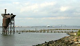
Most of the eastern shore of Newark Bay has homes and parks. The Hackensack RiverWalk is a path being built along the shore. It will connect parks from the Bayonne Bridge all the way to the Hackensack Meadowlands. In Bayonne, much of the bay still has its natural shoreline. The city's biggest parks are found along these shores. At Droyer's Point, there are new homes and a walking path along the water.
Howland Hook on Staten Island
The Howland Hook Marine Terminal is a large container port on the northwestern side of Staten Island. Nearby is Port Ivory, named after an old soap factory. To the east is Mariners Harbor, a neighborhood overlooking the bay. In the past, Bethlehem Steel had a plant here that built military ships. Today, you can find tugboat companies and smaller ship repair yards along this shore.
Pollution and Marine Life
Newark Bay has faced serious pollution problems. It is now a Superfund site, which means it's a place with a lot of pollution that needs to be cleaned up. Chemicals like PCBs, dioxin, mercury, and copper have been found in the bay.
These chemicals can be harmful to marine life. For example, chemicals found in the bay can be harmful to marine life and people if consumed. Because of the chemicals in the sediment (the mud at the bottom), catching crabs is not allowed, and there are limits on fishing.
Scientists study small fish called Mummichog in Newark Bay. These fish help them understand how pollution affects animals. The chemicals in the bay can change how these fish grow and reproduce. These fish have even adapted to live in the polluted environment.
2008 Ship Accident
In January 2008, a large ship called the Orange Sun hit a dredge boat in Newark Bay. A dredge boat is used for digging out the bottom of the bay. The bay had to be closed for five hours by the U.S. Coast Guard. The dredge boat started to take on water, and divers had to fix it. A report later said the Orange Sun was at fault. Its captain had not told the crew that the ship sometimes went off course.
 | Sharif Bey |
 | Hale Woodruff |
 | Richmond Barthé |
 | Purvis Young |


